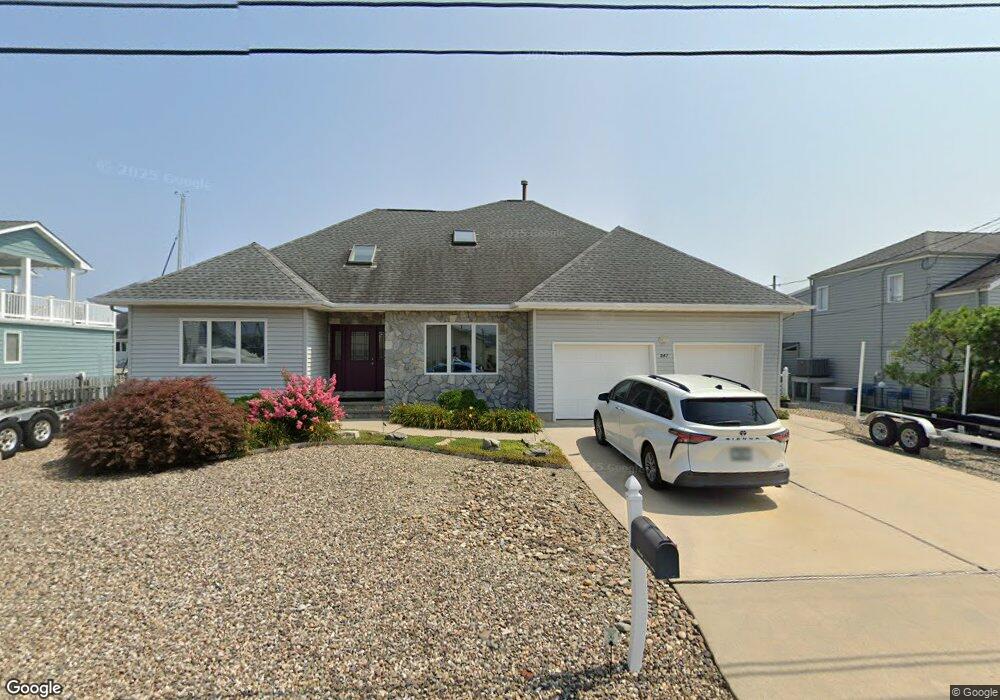
847 Spar Dr Forked River, NJ 08731
Estimated Value: $961,000 - $1,146,000
3
Beds
2
Baths
1,923
Sq Ft
$543/Sq Ft
Est. Value
About This Home
This home is located at 847 Spar Dr, Forked River, NJ 08731 and is currently estimated at $1,045,057, approximately $543 per square foot. 847 Spar Dr is a home located in Ocean County with nearby schools including Lacey Township High School.
Ownership History
Date
Name
Owned For
Owner Type
Purchase Details
Closed on
Dec 21, 2013
Sold by
Toussaint Properties Llc
Bought by
Toussaint Taylor N and Toussaint Linda M
Current Estimated Value
Purchase Details
Closed on
Mar 24, 2008
Sold by
Capital Construction Exchange Co Iii Llc
Bought by
Toussaint Properties Llc
Purchase Details
Closed on
Sep 27, 2007
Sold by
Sand & Rust Lp
Bought by
Capital Construction Exchange Co Iii Llc
Purchase Details
Closed on
Feb 8, 2005
Sold by
Russell Charles F and Russell Sandra M
Bought by
Sand & Rust Lp
Purchase Details
Closed on
Apr 19, 2001
Sold by
Cabarle Kenneth
Bought by
Russell Charles and Russell Sandra
Purchase Details
Closed on
Feb 26, 1996
Sold by
Wagner E O Alvin
Bought by
Cabarle Elizabeth and Cabarle Kenneth
Create a Home Valuation Report for This Property
The Home Valuation Report is an in-depth analysis detailing your home's value as well as a comparison with similar homes in the area
Home Values in the Area
Average Home Value in this Area
Purchase History
| Date | Buyer | Sale Price | Title Company |
|---|---|---|---|
| Toussaint Taylor N | -- | None Available | |
| Toussaint Properties Llc | -- | None Available | |
| Capital Construction Exchange Co Iii Llc | $710,000 | New Jersey Land Title | |
| Sand & Rust Lp | -- | -- | |
| Russell Charles | $480,000 | -- | |
| Russell Charles | $480,000 | -- | |
| Cabarle Elizabeth | $90,000 | -- |
Source: Public Records
Mortgage History
| Date | Status | Borrower | Loan Amount |
|---|---|---|---|
| Closed | Russell Charles | $0 |
Source: Public Records
Tax History
| Year | Tax Paid | Tax Assessment Tax Assessment Total Assessment is a certain percentage of the fair market value that is determined by local assessors to be the total taxable value of land and additions on the property. | Land | Improvement |
|---|---|---|---|---|
| 2025 | $15,207 | $556,000 | $287,500 | $268,500 |
| 2024 | $13,172 | $556,000 | $287,500 | $268,500 |
| 2023 | $12,582 | $556,000 | $287,500 | $268,500 |
| 2022 | $12,582 | $556,000 | $287,500 | $268,500 |
| 2021 | $12,365 | $556,000 | $287,500 | $268,500 |
| 2020 | $11,976 | $556,000 | $287,500 | $268,500 |
| 2019 | $11,765 | $556,000 | $287,500 | $268,500 |
| 2018 | $11,626 | $556,000 | $287,500 | $268,500 |
| 2017 | $11,359 | $556,000 | $287,500 | $268,500 |
| 2016 | $11,315 | $556,000 | $287,500 | $268,500 |
| 2015 | $10,809 | $556,000 | $287,500 | $268,500 |
| 2014 | $9,907 | $576,000 | $307,500 | $268,500 |
Source: Public Records
Map
Nearby Homes
- 814 Ensign Dr
- 816 Bowline Dr
- 0 Windward Dr Unit NJOC2039288
- 0 Windward Dr Unit 22601526
- 1025 Capstan Dr
- 1207 Capstan Dr
- 915 Shenandoah Dr
- 908 Shenandoah Dr
- 715 Richmond Dr
- 709 Richmond Dr
- 510 Conifer Dr
- 101 Foxwood Ln
- 1609 Tamiami Rd
- 108 Fernwood Ln
- 330 Riviera Dr
- 1215 Niihau Dr
- 1205 Niihau Dr
- 1201 Niihau Dr
- 231 Birch Ln
- 127 Driftwood Ln
Your Personal Tour Guide
Ask me questions while you tour the home.