Estimated Value: $256,139 - $279,000
3
Beds
2
Baths
1,200
Sq Ft
$222/Sq Ft
Est. Value
About This Home
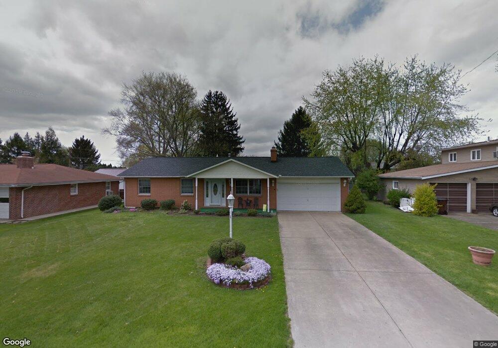
This home is located at 863 Wayne Dr, Heath, OH 43056 and is currently estimated at $266,535, approximately $222 per square foot. 863 Wayne Dr is a home located in Licking County with nearby schools including Garfield Elementary School, Stevenson Elementary School, and Heath Middle School.
Ownership History
Date
Name
Owned For
Owner Type
Purchase Details
Closed on
Feb 29, 2012
Sold by
Blizzard Robert P and Blizzard Gail A
Bought by
Careins Natalie L and Careins Brian D
Current Estimated Value
Home Financials for this Owner
Home Financials are based on the most recent Mortgage that was taken out on this home.
Original Mortgage
$85,000
Outstanding Balance
$56,953
Interest Rate
3.89%
Mortgage Type
New Conventional
Estimated Equity
$209,582
Purchase Details
Closed on
Aug 5, 2009
Sold by
Blackford Lloyd N and Blackford Ethel M
Bought by
Blackford Lloyd N and Blackford Ethel M
Create a Home Valuation Report for This Property
The Home Valuation Report is an in-depth analysis detailing your home's value as well as a comparison with similar homes in the area
Home Values in the Area
Average Home Value in this Area
Purchase History
| Date | Buyer | Sale Price | Title Company |
|---|---|---|---|
| Careins Natalie L | $115,000 | None Available | |
| Blackford Lloyd N | -- | Park Title |
Source: Public Records
Mortgage History
| Date | Status | Borrower | Loan Amount |
|---|---|---|---|
| Open | Careins Natalie L | $85,000 |
Source: Public Records
Tax History
| Year | Tax Paid | Tax Assessment Tax Assessment Total Assessment is a certain percentage of the fair market value that is determined by local assessors to be the total taxable value of land and additions on the property. | Land | Improvement |
|---|---|---|---|---|
| 2024 | $3,239 | $75,290 | $15,470 | $59,820 |
| 2023 | $3,585 | $75,290 | $15,470 | $59,820 |
| 2022 | $3,862 | $46,660 | $11,590 | $35,070 |
| 2021 | $2,581 | $46,660 | $11,590 | $35,070 |
| 2020 | $2,597 | $46,660 | $11,590 | $35,070 |
| 2019 | $2,448 | $44,770 | $12,880 | $31,890 |
| 2018 | $2,474 | $0 | $0 | $0 |
| 2017 | $2,108 | $0 | $0 | $0 |
| 2016 | $1,714 | $0 | $0 | $0 |
| 2015 | $1,743 | $0 | $0 | $0 |
| 2014 | $2,451 | $0 | $0 | $0 |
| 2013 | $1,611 | $0 | $0 | $0 |
Source: Public Records
Map
Nearby Homes
- 944 Fieldson Dr
- 164 Licking View Dr
- 780 Fieldson Dr
- 101 Fieldpoint Rd
- 18 Swainford Dr
- 231 Fieldpoint Rd
- 514 S 30th St
- 233 Wildwood Ct Unit 233C
- 105 Clark Ave
- 1285 Bluejack Ln
- 224 Walden Rd
- 1094 Aldine Dr
- 381 Laurel Oaks Ln
- 616 Huron Dr
- 92 Jonathan Dr
- 399 Laurel Oaks Ln Unit Lot 131
- 403 Laurel Oaks Ln Unit Lot 132
- 307 Nicholas Dr Unit 46
- 1265 Green Valley Dr
- 1223 W Main St
Your Personal Tour Guide
Ask me questions while you tour the home.