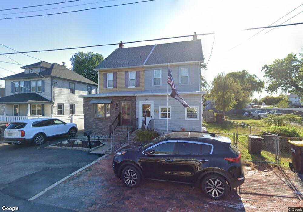
882 Simons Ave Bensalem, PA 19020
Estimated Value: $324,000 - $408,000
4
Beds
2
Baths
1,672
Sq Ft
$225/Sq Ft
Est. Value
About This Home
This home is located at 882 Simons Ave, Bensalem, PA 19020 and is currently estimated at $376,448, approximately $225 per square foot. 882 Simons Ave is a home located in Bucks County with nearby schools including Robert K. Shafer Middle School, School Lane Charter School, and St Charles Borromeo School.
Ownership History
Date
Name
Owned For
Owner Type
Purchase Details
Closed on
Jul 30, 2009
Sold by
Michalik Leonard M and Michalik Deborah A
Bought by
Higgins Ii Thomas
Current Estimated Value
Home Financials for this Owner
Home Financials are based on the most recent Mortgage that was taken out on this home.
Original Mortgage
$221,906
Outstanding Balance
$145,413
Interest Rate
5.47%
Mortgage Type
FHA
Estimated Equity
$231,035
Purchase Details
Closed on
May 2, 1990
Bought by
Michalik Leonard M and Michalik Deborah A
Create a Home Valuation Report for This Property
The Home Valuation Report is an in-depth analysis detailing your home's value as well as a comparison with similar homes in the area
Home Values in the Area
Average Home Value in this Area
Purchase History
| Date | Buyer | Sale Price | Title Company |
|---|---|---|---|
| Higgins Ii Thomas | $226,000 | None Available | |
| Michalik Leonard M | $95,000 | -- |
Source: Public Records
Mortgage History
| Date | Status | Borrower | Loan Amount |
|---|---|---|---|
| Open | Higgins Ii Thomas | $221,906 |
Source: Public Records
Tax History
| Year | Tax Paid | Tax Assessment Tax Assessment Total Assessment is a certain percentage of the fair market value that is determined by local assessors to be the total taxable value of land and additions on the property. | Land | Improvement |
|---|---|---|---|---|
| 2025 | $2,532 | $11,600 | $1,480 | $10,120 |
| 2024 | $2,532 | $11,600 | $1,480 | $10,120 |
| 2023 | $2,461 | $11,600 | $1,480 | $10,120 |
| 2022 | $2,446 | $11,600 | $1,480 | $10,120 |
| 2021 | $2,446 | $11,600 | $1,480 | $10,120 |
| 2020 | $2,422 | $11,600 | $1,480 | $10,120 |
| 2019 | $2,368 | $11,600 | $1,480 | $10,120 |
| 2018 | $2,313 | $11,600 | $1,480 | $10,120 |
| 2017 | $2,298 | $11,600 | $1,480 | $10,120 |
| 2016 | $2,298 | $11,600 | $1,480 | $10,120 |
| 2015 | -- | $11,600 | $1,480 | $10,120 |
| 2014 | -- | $11,600 | $1,480 | $10,120 |
Source: Public Records
Map
Nearby Homes
- 921 Simons Ave
- 876 Williams Ave
- 1341 Corry Ave
- 2025 State Rd
- 1232 Woodbine Ave
- 110 Konefal St
- 128 Federal St
- 135 Prince George St
- 140A Gaslight Aly
- 129 Prince George St
- 142A Annapolis St Unit A
- 128B Fleet Ct
- 124 Alexandria St
- 146A Park Place
- 117B Prince George St
- 109 Federal St
- 116B King St
- 112 B King St
- 114B King St
- 115A King St
- 884 Simons Ave
- 876 Simons Ave
- 910 Simons Ave
- 870 Simons Ave
- 2 Simons Dr
- 1 Simons Dr
- 01 Simons Ave
- 02 Simons Ave
- 864 Simons Ave
- 912 Simons Ave
- 917 Cornwells Ave
- 885 Simons Ave
- 858 Simons Ave
- 911 Cornwells Ave
- 923 Cornwells Ave
- 875 Simons Ave
- 924 Simons Ave
- 931 Cornwells Ave
- 903 Cornwells Ave
- 905 Simons Ave
Your Personal Tour Guide
Ask me questions while you tour the home.