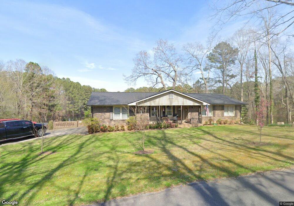
9 Hillside Dr Rockmart, GA 30153
Estimated Value: $269,457 - $309,000
3
Beds
2
Baths
1,744
Sq Ft
$165/Sq Ft
Est. Value
About This Home
This home is located at 9 Hillside Dr, Rockmart, GA 30153 and is currently estimated at $287,614, approximately $164 per square foot. 9 Hillside Dr is a home located in Polk County with nearby schools including Rockmart Middle School.
Ownership History
Date
Name
Owned For
Owner Type
Purchase Details
Closed on
Dec 1, 1995
Sold by
Fugate Millard Layton
Bought by
Swift Debbie As Executor Of Estate Of
Current Estimated Value
Purchase Details
Closed on
Nov 11, 1995
Sold by
Fugate Millard L Aka Millard Layton F
Bought by
Swift Debbie
Purchase Details
Closed on
Jun 20, 1986
Sold by
Fugate Millard L
Bought by
Fugate Millard L
Purchase Details
Closed on
Dec 18, 1975
Sold by
Phillips Carl S
Bought by
Fugate Millard L
Purchase Details
Closed on
Apr 21, 1975
Sold by
Battles Carl W
Bought by
Phillips Carl S
Purchase Details
Closed on
Jun 12, 1971
Sold by
Hayes Paul
Bought by
Battles Carl W
Purchase Details
Closed on
Jun 24, 1967
Sold by
Brumit Larry A
Bought by
Hayes Paul
Purchase Details
Closed on
Jan 1, 1901
Bought by
Brumit Larry A
Create a Home Valuation Report for This Property
The Home Valuation Report is an in-depth analysis detailing your home's value as well as a comparison with similar homes in the area
Home Values in the Area
Average Home Value in this Area
Purchase History
| Date | Buyer | Sale Price | Title Company |
|---|---|---|---|
| Swift Debbie As Executor Of Estate Of | -- | -- | |
| Swift Debbie | -- | -- | |
| Fugate Millard L | -- | -- | |
| Fugate Millard L | -- | -- | |
| Phillips Carl S | -- | -- | |
| Battles Carl W | -- | -- | |
| Hayes Paul | -- | -- | |
| Brumit Larry A | -- | -- |
Source: Public Records
Tax History
| Year | Tax Paid | Tax Assessment Tax Assessment Total Assessment is a certain percentage of the fair market value that is determined by local assessors to be the total taxable value of land and additions on the property. | Land | Improvement |
|---|---|---|---|---|
| 2025 | $2,240 | $101,556 | $8,000 | $93,556 |
| 2024 | $2,081 | $101,556 | $8,000 | $93,556 |
| 2023 | $1,610 | $69,825 | $8,000 | $61,825 |
| 2022 | $1,421 | $61,892 | $8,000 | $53,892 |
| 2021 | $1,440 | $61,892 | $8,000 | $53,892 |
| 2020 | $1,443 | $61,892 | $8,000 | $53,892 |
| 2019 | $1,130 | $44,070 | $5,100 | $38,970 |
| 2018 | $1,133 | $43,104 | $5,100 | $38,004 |
| 2017 | $1,119 | $43,104 | $5,100 | $38,004 |
| 2016 | $1,119 | $43,104 | $5,100 | $38,004 |
| 2015 | $1,129 | $43,360 | $5,100 | $38,260 |
| 2014 | $1,112 | $42,448 | $4,188 | $38,260 |
Source: Public Records
Map
Nearby Homes
- 214 Horseshoe Cir
- 865 Morgan Valley Rd
- 184 Morgan Ln
- 60 Lee St
- 479 Morgan Valley Rd
- 92 Autumn Path
- 0 Pine Mountain St Unit 10620510
- 0 Pine Mountain St Unit 10620492
- 1714 Cedartown Hwy
- 1 Pine Mountain Rd
- 831 Government Farm Rd
- 135 2nd St
- 816 Government Farm Rd
- 601 Calloway Dr
- 740 Calloway Dr
- 65 Wheeler Rd
- 702 Calloway Dr
- 202 Gordon St
- 713 Church St
- 271 Mccowan Cir
Your Personal Tour Guide
Ask me questions while you tour the home.