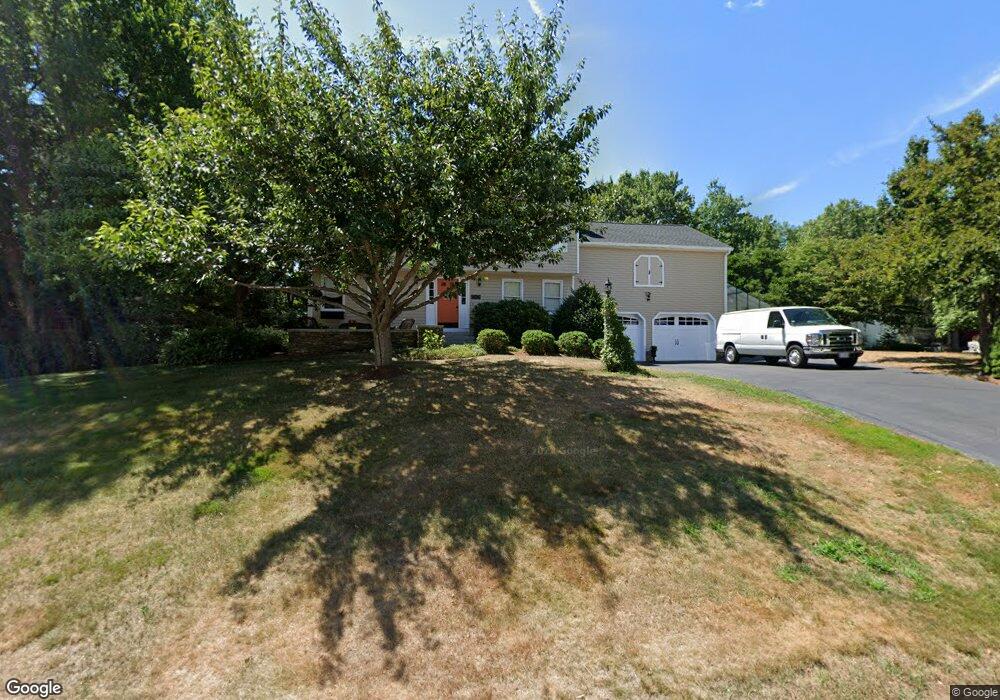
9 Pheasant Run Rd Medway, MA 02053
Estimated Value: $775,899 - $884,000
4
Beds
4
Baths
2,373
Sq Ft
$349/Sq Ft
Est. Value
About This Home
This home is located at 9 Pheasant Run Rd, Medway, MA 02053 and is currently estimated at $827,225, approximately $348 per square foot. 9 Pheasant Run Rd is a home located in Norfolk County with nearby schools including John D. McGovern Elementary School, Burke-Memorial Elementary, and Medway Middle School.
Ownership History
Date
Name
Owned For
Owner Type
Purchase Details
Closed on
Nov 15, 1994
Sold by
Al Miraj Inc
Bought by
Kennedy Alan W and Kennedy Kathleen
Current Estimated Value
Create a Home Valuation Report for This Property
The Home Valuation Report is an in-depth analysis detailing your home's value as well as a comparison with similar homes in the area
Home Values in the Area
Average Home Value in this Area
Purchase History
| Date | Buyer | Sale Price | Title Company |
|---|---|---|---|
| Kennedy Alan W | $180,050 | -- |
Source: Public Records
Mortgage History
| Date | Status | Borrower | Loan Amount |
|---|---|---|---|
| Open | Kennedy Alan W | $220,500 | |
| Closed | Kennedy Alan W | $50,000 | |
| Closed | Kennedy Alan W | $158,500 |
Source: Public Records
Tax History
| Year | Tax Paid | Tax Assessment Tax Assessment Total Assessment is a certain percentage of the fair market value that is determined by local assessors to be the total taxable value of land and additions on the property. | Land | Improvement |
|---|---|---|---|---|
| 2025 | $9,937 | $697,300 | $322,900 | $374,400 |
| 2024 | $10,041 | $697,300 | $322,900 | $374,400 |
| 2023 | $10,020 | $628,600 | $293,900 | $334,700 |
| 2022 | $9,030 | $533,400 | $217,400 | $316,000 |
| 2021 | $8,908 | $510,200 | $202,900 | $307,300 |
| 2020 | $8,729 | $498,800 | $202,900 | $295,900 |
| 2019 | $8,247 | $486,000 | $194,600 | $291,400 |
| 2018 | $8,316 | $470,900 | $186,300 | $284,600 |
| 2017 | $8,455 | $471,800 | $191,800 | $280,000 |
| 2016 | $8,267 | $456,500 | $176,500 | $280,000 |
| 2015 | $8,204 | $449,800 | $174,300 | $275,500 |
| 2014 | $7,973 | $423,200 | $174,300 | $248,900 |
Source: Public Records
Map
Nearby Homes
- 6 Freedom Trail
- 3 Harmony Way Unit 3
- 72 Fisher St
- 7 Holbrook St
- 176 Main St Unit 3
- 394 Village St
- 371 Village St
- 9 Franklin St
- 23 Tulip Way
- 21 Cottage St
- 1 Heritage Dr
- 26 Timber Crest Dr
- 40 Timber Crest Dr
- 6 Sycamore Way
- 23 Howe St
- 17 Hawthorne Village Unit A
- 34 Betten Ct
- 359 Hartford Ave
- LOT 8 Pond View
- 21 Maple St
- 11 Pheasant Run Rd
- 13 Pheasant Run Rd
- 12 Pheasant Run Rd
- 10 Pheasant Run Rd
- 14 Pheasant Run Rd
- 6 Pheasant Run Rd
- 4 Pheasant Run Rd
- 7 Azalea Dr
- 9 Azalea Dr
- 5 Pheasant Run Rd
- 5 Azalea Dr
- 5 Quail Dr
- 15 Pheasant Run Rd
- 28 Hooksett Cir
- 26 Hooksett Cir
- 7 Quail Dr
- 18 Dogwood Ln
- 16 Pheasant Run Rd
- 3 Azalea Dr
- 1 Quail Dr
Your Personal Tour Guide
Ask me questions while you tour the home.