Estimated Value: $725,951 - $1,131,000
3
Beds
2
Baths
984
Sq Ft
$906/Sq Ft
Est. Value
About This Home
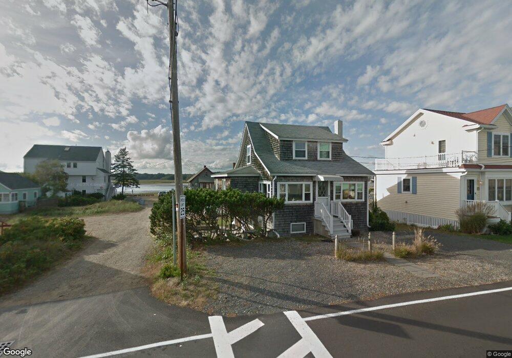
This home is located at 9 Pickett Ln, Wells, ME 04090 and is currently estimated at $891,488, approximately $905 per square foot. 9 Pickett Ln is a home located in York County with nearby schools including Wells Junior High School, Wells Elementary School, and Wells High School.
Ownership History
Date
Name
Owned For
Owner Type
Purchase Details
Closed on
Sep 16, 2021
Sold by
Mccann Mary H and Mccann Steven H
Bought by
Mccann Mary H and Mccann Steven H
Current Estimated Value
Purchase Details
Closed on
Mar 15, 2017
Sold by
Mccann Mary H
Bought by
Mccann Mary H and Mccann Steven H
Home Financials for this Owner
Home Financials are based on the most recent Mortgage that was taken out on this home.
Original Mortgage
$287,500
Interest Rate
4.19%
Mortgage Type
New Conventional
Purchase Details
Closed on
Jan 12, 2006
Sold by
Mccann Steven H
Bought by
Mccann M H
Create a Home Valuation Report for This Property
The Home Valuation Report is an in-depth analysis detailing your home's value as well as a comparison with similar homes in the area
Home Values in the Area
Average Home Value in this Area
Purchase History
| Date | Buyer | Sale Price | Title Company |
|---|---|---|---|
| Mccann Mary H | -- | None Available | |
| Mccann Mary H | -- | None Available | |
| Mccann Mary H | -- | None Available | |
| Mccann Mary H | -- | -- | |
| Mccann Mary H | -- | -- | |
| Mccann Mary H | -- | -- | |
| Mccann M H | -- | -- | |
| Mccann M H | -- | -- |
Source: Public Records
Mortgage History
| Date | Status | Borrower | Loan Amount |
|---|---|---|---|
| Previous Owner | Mccann Mary H | $287,500 |
Source: Public Records
Tax History
| Year | Tax Paid | Tax Assessment Tax Assessment Total Assessment is a certain percentage of the fair market value that is determined by local assessors to be the total taxable value of land and additions on the property. | Land | Improvement |
|---|---|---|---|---|
| 2025 | $4,539 | $702,620 | $521,400 | $181,220 |
| 2024 | $4,272 | $702,620 | $521,400 | $181,220 |
| 2023 | $4,188 | $702,620 | $521,400 | $181,220 |
| 2022 | $4,588 | $438,670 | $339,500 | $99,170 |
| 2021 | $4,601 | $437,340 | $339,500 | $97,840 |
| 2020 | $4,510 | $430,360 | $339,500 | $90,860 |
| 2019 | $4,484 | $430,360 | $339,500 | $90,860 |
| 2018 | $4,441 | $430,360 | $339,500 | $90,860 |
| 2017 | $4,372 | $430,360 | $339,500 | $90,860 |
| 2016 | $4,329 | $430,360 | $339,500 | $90,860 |
| 2015 | $4,278 | $429,960 | $339,500 | $90,460 |
| 2013 | $3,921 | $429,960 | $339,500 | $90,460 |
Source: Public Records
Map
Nearby Homes
- 9 Robert Ln
- 446 Atlantic Ave
- 0 Eastern Ave
- 465 Atlantic Ave
- 500 Atlantic Ave Unit 2
- 225 Atlantic Ave
- 99 Harbor Rd Unit Lot 52
- 99 Harbor Rd Unit Lot 54
- 4 Tidal Ct
- 1351 Post Rd Unit 49
- 1373 Post Rd Unit 12E
- 1373 Post Rd Unit 10A
- 1373 Post Rd Unit 2C
- 1373 Post Rd Unit 6B
- 1373 Post Rd Unit 1F
- 1801 Post Rd Unit 128
- 1801 Post Rd Unit 190
- 1413 Post Rd Unit 58
- 28 Coggeshall Ln
- 60 Mile Rd Unit 41
- 17 Pickett Ln
- 15 Pickett Ln
- 16 Pickett Ln
- 376 Atlantic Ave
- 380 Atlantic Ave
- 382 Atlantic Ave
- 10 Pickett Ln
- 0 Riverside Dr Unit 549095
- 0 Riverside Dr Unit 546953
- 0 Riverside Dr Unit 593693
- 0 Riverside Dr Unit 586257
- 0 Riverside Dr Unit 575333
- 0 Riverside Dr Unit 547353
- 0 Riverside Dr Unit 930466
- 0 Riverside Dr Unit 1022596
- 372 Atlantic Ave
- 388 Atlantic Ave
- 368 Atlantic Ave
- 377 Atlantic Ave
- 381 Atlantic Ave
Your Personal Tour Guide
Ask me questions while you tour the home.