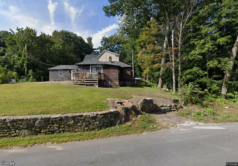
9 S Shore Rd Westminster, MA 01473
Estimated Value: $293,000 - $464,000
About This Home
This home is located at 9 S Shore Rd, Westminster, MA 01473 and is currently estimated at $382,595, approximately $306 per square foot. 9 S Shore Rd is a home located in Worcester County with nearby schools including Oakmont Regional High School.
Ownership History
We collect this data history from publicly available records. To have your information removed, we recommend requesting removal directly through your county’s website.
Purchase Details
Home Financials for this Owner
Home Financials are based on the most recent Mortgage that was taken out on this home.Home Values in the Area
Average Home Value in this Area
Purchase History
We collect this data history from publicly available records. To have your information removed, we recommend requesting removal directly through your county’s website.
| Date | Buyer | Sale Price | Title Company |
|---|---|---|---|
| $75,000 | -- |
Mortgage History
We collect this data history from publicly available records. To have your information removed, we recommend requesting removal directly through your county’s website.
| Date | Status | Borrower | Loan Amount |
|---|---|---|---|
| Open | $48,750 |
Tax History
We collect this data history from publicly available records. To have your information removed, we recommend requesting removal directly through your county’s website.
| Year | Tax Paid | Tax Assessment Tax Assessment Total Assessment is a certain percentage of the fair market value that is determined by local assessors to be the total taxable value of land and additions on the property. | Land | Improvement |
|---|---|---|---|---|
| 2025 | $3,528 | $286,800 | $111,800 | $175,000 |
| 2024 | $3,395 | $276,900 | $111,800 | $165,100 |
| 2023 | $3,453 | $264,400 | $104,500 | $159,900 |
| 2022 | $3,356 | $212,400 | $90,900 | $121,500 |
| 2021 | $3,310 | $197,500 | $75,200 | $122,300 |
| 2020 | $3,222 | $183,600 | $68,400 | $115,200 |
| 2019 | $3,134 | $171,700 | $56,500 | $115,200 |
| 2018 | $2,638 | $142,200 | $56,500 | $85,700 |
| 2017 | $2,550 | $140,200 | $56,500 | $83,700 |
| 2016 | $2,438 | $129,800 | $47,100 | $82,700 |
| 2015 | $2,405 | $126,900 | $47,100 | $79,800 |
| 2014 | $2,409 | $126,900 | $47,100 | $79,800 |
Map
- 10 East Rd
- Lot 0 Narrows Rd
- 3 Woods Rd
- 2 Tandem Dr Unit B
- 115 East Rd
- 1 Newcomb Rd
- 17 Leominster St
- 76 Saw Mill Pond Rd
- 51 Sawmill Pond Rd Unit 51
- 2 Roberts Way
- 7 Brooks Ave
- 39 N Common Rd
- 9 Knower Rd
- 6 Mason Ln
- 9 Syd Smith Rd
- 0 Syd Smith Rd Unit 73395578
- 0 Syd Smith Rd (Rear)
- 0 Syd Smith Rd Map 71 Lot 4-2
- 0
- 26-28 Eureka St
Ask me questions while you tour the home.