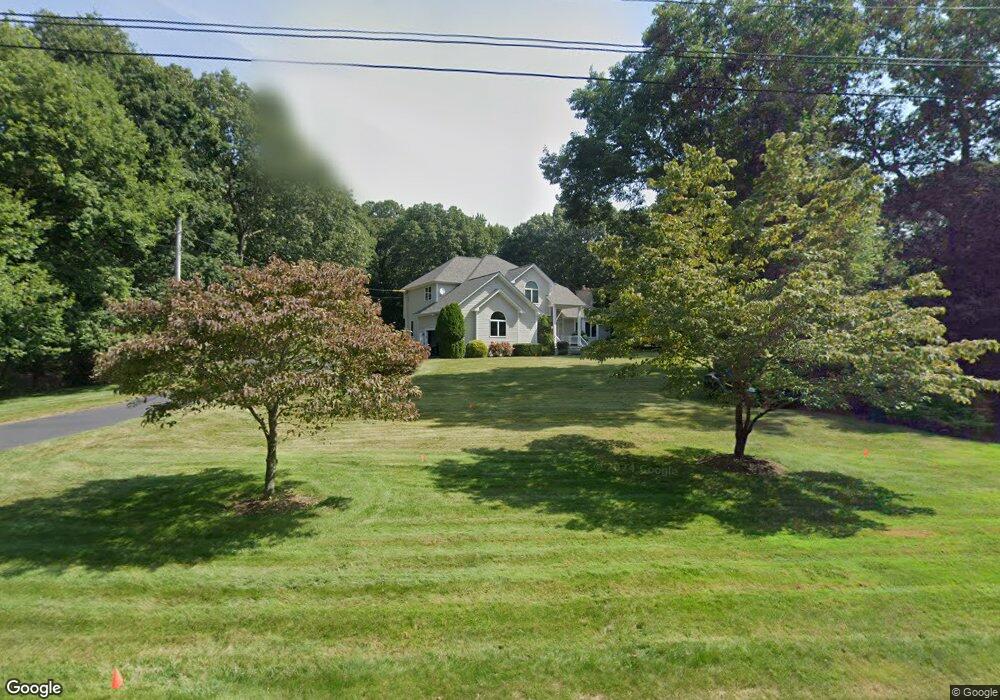
9 Sylvan Ct Saunderstown, RI 02874
Saunderstown NeighborhoodEstimated Value: $1,058,440 - $1,313,000
About This Home
This home is located at 9 Sylvan Ct, Saunderstown, RI 02874 and is currently estimated at $1,230,610, approximately $464 per square foot. 9 Sylvan Ct is a home located in Washington County with nearby schools including Stony Lane Elementary School, Wickford Middle School, and North Kingstown Sr. High School.
Ownership History
We collect this data history from publicly available records. To have your information removed, we recommend requesting removal directly through your county’s website.
Purchase Details
Home Values in the Area
Average Home Value in this Area
Purchase History
We collect this data history from publicly available records. To have your information removed, we recommend requesting removal directly through your county’s website.
| Date | Buyer | Sale Price | Title Company |
|---|---|---|---|
| $379,000 | -- |
Mortgage History
We collect this data history from publicly available records. To have your information removed, we recommend requesting removal directly through your county’s website.
| Date | Status | Borrower | Loan Amount |
|---|---|---|---|
| Open | $179,000 | ||
| Previous Owner | $100,000 | ||
| Previous Owner | $75,000 |
Tax History
We collect this data history from publicly available records. To have your information removed, we recommend requesting removal directly through your county’s website.
| Year | Tax Paid | Tax Assessment Tax Assessment Total Assessment is a certain percentage of the fair market value that is determined by local assessors to be the total taxable value of land and additions on the property. | Land | Improvement |
|---|---|---|---|---|
| 2025 | $9,915 | $898,100 | $312,100 | $586,000 |
| 2024 | $10,164 | $708,800 | $269,800 | $439,000 |
| 2023 | $10,164 | $708,800 | $269,800 | $439,000 |
| 2022 | $9,966 | $708,800 | $269,800 | $439,000 |
| 2021 | $9,389 | $536,500 | $175,500 | $361,000 |
| 2020 | $9,169 | $536,500 | $175,500 | $361,000 |
| 2019 | $9,169 | $536,500 | $175,500 | $361,000 |
| 2018 | $8,726 | $460,000 | $144,700 | $315,300 |
| 2017 | $8,551 | $460,000 | $144,700 | $315,300 |
| 2016 | $8,308 | $460,000 | $144,700 | $315,300 |
| 2015 | $8,349 | $432,600 | $144,700 | $287,900 |
| 2014 | $8,180 | $432,600 | $144,700 | $287,900 |
Map
- 91 Woodridge Dr
- 79 Explorer Dr
- 210 Explorer Dr
- 0 Explorer Dr
- 0 Explorer Dr
- 11 Prides Crossing Ln
- 19 Blacksburt Ct
- 470 Sylvan Ct
- 136 Holly Hills Ln
- 116 Holly Hills Ln
- 52 Haggarty Hill Rd
- 320 Railroad Ave
- 64 Fieldstone Ln
- 571 Stony Fort Rd
- 604 Stony Fort Rd
- 101 Cardinal Dr
- 394 Westmoreland Ln
- 5 Woodbine Ln
- 167 Liberty Rd
- 313 Westmoreland Ln
Ask me questions while you tour the home.