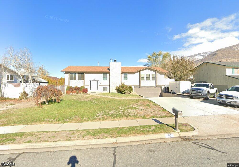
90 W 625 N Centerville, UT 84014
Estimated Value: $551,000 - $639,000
5
Beds
3
Baths
2,678
Sq Ft
$224/Sq Ft
Est. Value
About This Home
This home is located at 90 W 625 N, Centerville, UT 84014 and is currently estimated at $598,548, approximately $223 per square foot. 90 W 625 N is a home located in Davis County with nearby schools including Centerville Elementary, Centerville Jr High, and Viewmont High School.
Ownership History
Date
Name
Owned For
Owner Type
Purchase Details
Closed on
Jul 22, 2008
Sold by
Mylonakis Michael
Bought by
Call Cameron Bowen and Call Jenifer D
Current Estimated Value
Home Financials for this Owner
Home Financials are based on the most recent Mortgage that was taken out on this home.
Original Mortgage
$266,000
Outstanding Balance
$173,680
Interest Rate
6.31%
Mortgage Type
VA
Estimated Equity
$424,868
Purchase Details
Closed on
May 21, 2007
Sold by
Mylonakis Michael and Huston Karen
Bought by
Mylonakis Michael
Home Financials for this Owner
Home Financials are based on the most recent Mortgage that was taken out on this home.
Original Mortgage
$198,000
Interest Rate
6.18%
Mortgage Type
New Conventional
Purchase Details
Closed on
Nov 17, 2006
Sold by
Vomdorp Robert E and Vomdorp Janice G
Bought by
Mylonakis Michael and Huston Karen
Home Financials for this Owner
Home Financials are based on the most recent Mortgage that was taken out on this home.
Original Mortgage
$197,200
Interest Rate
6.28%
Mortgage Type
New Conventional
Purchase Details
Closed on
Sep 28, 2006
Sold by
Hemsley Jill S
Bought by
Vomdorp Robert E and Vomdorp Janice G
Home Financials for this Owner
Home Financials are based on the most recent Mortgage that was taken out on this home.
Original Mortgage
$197,200
Interest Rate
6.28%
Mortgage Type
New Conventional
Purchase Details
Closed on
May 24, 2006
Sold by
Hemsley Jill S
Bought by
Hemsley Jill S
Home Financials for this Owner
Home Financials are based on the most recent Mortgage that was taken out on this home.
Original Mortgage
$148,000
Interest Rate
6.52%
Mortgage Type
Fannie Mae Freddie Mac
Purchase Details
Closed on
Jan 2, 1997
Sold by
Hemsley Lane A
Bought by
Hemsley Jill S
Home Financials for this Owner
Home Financials are based on the most recent Mortgage that was taken out on this home.
Original Mortgage
$60,000
Interest Rate
7.07%
Create a Home Valuation Report for This Property
The Home Valuation Report is an in-depth analysis detailing your home's value as well as a comparison with similar homes in the area
Purchase History
| Date | Buyer | Sale Price | Title Company |
|---|---|---|---|
| Call Cameron Bowen | -- | Executive Title Ins Agency | |
| Mylonakis Michael | -- | Title One Inc | |
| Mylonakis Michael | -- | Equity Title Ins Agency Inc | |
| Vomdorp Robert E | -- | Backman Title Services | |
| Hemsley Jill S | -- | Accommodation | |
| Hemsley Jill S | -- | First American Title | |
| Hemsley Jill S | -- | Associated Title Company |
Source: Public Records
Mortgage History
| Date | Status | Borrower | Loan Amount |
|---|---|---|---|
| Open | Call Cameron Bowen | $266,000 | |
| Previous Owner | Mylonakis Michael | $198,000 | |
| Previous Owner | Mylonakis Michael | $197,200 | |
| Previous Owner | Vomdorp Robert E | $149,925 | |
| Previous Owner | Hemsley Jill S | $148,000 | |
| Previous Owner | Hemsley Jill S | $20,000 | |
| Previous Owner | Hemsley Jill S | $60,000 |
Source: Public Records
Tax History
| Year | Tax Paid | Tax Assessment Tax Assessment Total Assessment is a certain percentage of the fair market value that is determined by local assessors to be the total taxable value of land and additions on the property. | Land | Improvement |
|---|---|---|---|---|
| 2025 | -- | $310,750 | $169,313 | $141,437 |
| 2024 | -- | $301,950 | $153,446 | $148,504 |
| 2023 | $180 | $520,000 | $249,845 | $270,155 |
| 2022 | $180 | $301,400 | $126,535 | $174,865 |
| 2021 | $0 | $424,000 | $195,195 | $228,805 |
| 2020 | $2,139 | $366,000 | $189,627 | $176,373 |
| 2019 | $2,139 | $362,000 | $186,672 | $175,328 |
| 2018 | $0 | $331,000 | $172,459 | $158,541 |
| 2016 | $1,984 | $160,380 | $56,736 | $103,644 |
| 2015 | $1,926 | $146,850 | $56,736 | $90,114 |
| 2014 | $1,761 | $137,386 | $56,736 | $80,650 |
| 2013 | $1,763 | $126,673 | $48,624 | $78,049 |
Source: Public Records
Map
Nearby Homes
- 282 W 605 N Unit A
- 282 W 605 N Unit I
- 281 W 650 N Unit B
- 303 W 650 N Unit I
- 165 W Pheasantbrook Dr
- 775 Pheasantbrook Cir
- 66 Brookside Ln
- 781 Pheasantbrook Dr
- 563 N 220 E
- 56 W 200 N
- 493 W 620 N Unit 122
- 132 W 200 N
- 507 W 620 N
- 185 N 50 W
- 243 Balsam Dr
- 271 Brookfield Ln
- 380 E 400 N
- 147 N 360 W Unit 21
- 638 N 800 W
- 2 S 285 W
Your Personal Tour Guide
Ask me questions while you tour the home.