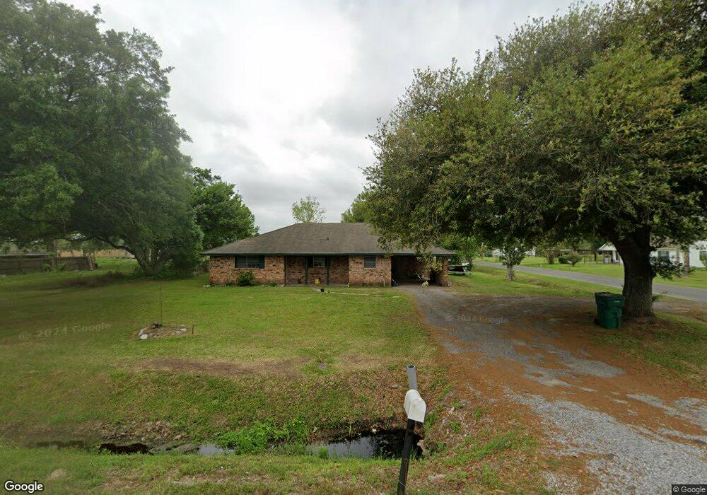
907 Parish Rd Vinton, LA 70668
Estimated Value: $94,000 - $501,000
3
Beds
1
Bath
1,375
Sq Ft
$157/Sq Ft
Est. Value
About This Home
This home is located at 907 Parish Rd, Vinton, LA 70668 and is currently estimated at $215,924, approximately $157 per square foot. 907 Parish Rd is a home located in Calcasieu Parish with nearby schools including Vinton Elementary School, Vinton Middle School, and Vinton High School.
Ownership History
Date
Name
Owned For
Owner Type
Purchase Details
Closed on
Jun 25, 2025
Sold by
Stanley Belinda
Bought by
Ashwood Investments and Union Bank
Current Estimated Value
Purchase Details
Closed on
Jan 31, 2022
Sold by
Pb & J Rentals
Bought by
Stanley Belinda
Purchase Details
Closed on
Oct 16, 2012
Sold by
Leblanc Samuel Adam and Leblanc Patricia Dawn
Bought by
Crain Genevieve Murphy and Murphy Shirley Ann
Purchase Details
Closed on
Jun 16, 2010
Sold by
Hsbc Bank Usa National Association
Bought by
Leblanc Samuel Adam and Leblanc Patricia Dawn
Purchase Details
Closed on
Aug 22, 2005
Sold by
Crain Genevieve Murphy and Guillory Gertrude Murphy
Bought by
Gragg Michael Aaron
Home Financials for this Owner
Home Financials are based on the most recent Mortgage that was taken out on this home.
Original Mortgage
$55,000
Interest Rate
6.85%
Mortgage Type
Adjustable Rate Mortgage/ARM
Create a Home Valuation Report for This Property
The Home Valuation Report is an in-depth analysis detailing your home's value as well as a comparison with similar homes in the area
Home Values in the Area
Average Home Value in this Area
Purchase History
| Date | Buyer | Sale Price | Title Company |
|---|---|---|---|
| Ashwood Investments | -- | -- | |
| Stanley Belinda | -- | None Listed On Document | |
| Crain Genevieve Murphy | -- | None Available | |
| Leblanc Samuel Adam | $38,000 | None Available | |
| Gragg Michael Aaron | -- | None Available |
Source: Public Records
Mortgage History
| Date | Status | Borrower | Loan Amount |
|---|---|---|---|
| Previous Owner | Gragg Michael Aaron | $55,000 |
Source: Public Records
Tax History
| Year | Tax Paid | Tax Assessment Tax Assessment Total Assessment is a certain percentage of the fair market value that is determined by local assessors to be the total taxable value of land and additions on the property. | Land | Improvement |
|---|---|---|---|---|
| 2025 | $822 | $7,030 | $400 | $6,630 |
| 2024 | $822 | $7,030 | $400 | $6,630 |
| 2023 | $840 | $7,030 | $400 | $6,630 |
| 2022 | $850 | $7,030 | $400 | $6,630 |
| 2021 | $915 | $7,030 | $400 | $6,630 |
| 2020 | $899 | $6,350 | $380 | $5,970 |
| 2019 | $891 | $7,030 | $400 | $6,630 |
| 2018 | $922 | $7,030 | $400 | $6,630 |
| 2017 | $929 | $7,030 | $400 | $6,630 |
| 2016 | $47 | $7,030 | $400 | $6,630 |
| 2015 | $47 | $7,010 | $380 | $6,630 |
Source: Public Records
Map
Nearby Homes
- 601 East St
- 1025.5 Horridge St
- 906 West St
- 1110 Nelson St
- 1706 Mill St
- 1102 Elsie St
- 1201 Highway 90
- 1121 Stevenson St
- 1201-1-7 Us 90
- 0 Vincent St Unit SWL22001378
- 1329 Horridge St
- 1306 Fancher St
- 1335 Horridge St
- 1310 Fancher St
- 821 Loree St
- 1412 East St
- 1409 Nelson St
- 1411 Horridge St
- 816 Goodwin St
- 1417 Eddy St
Your Personal Tour Guide
Ask me questions while you tour the home.