
Landlord's Agent in 2018
Jeremy Larkin
Keller Williams Realty The Woodlands
(832) 622-8100
574 Total Sales

Estimated Value: $460,000 - $491,000
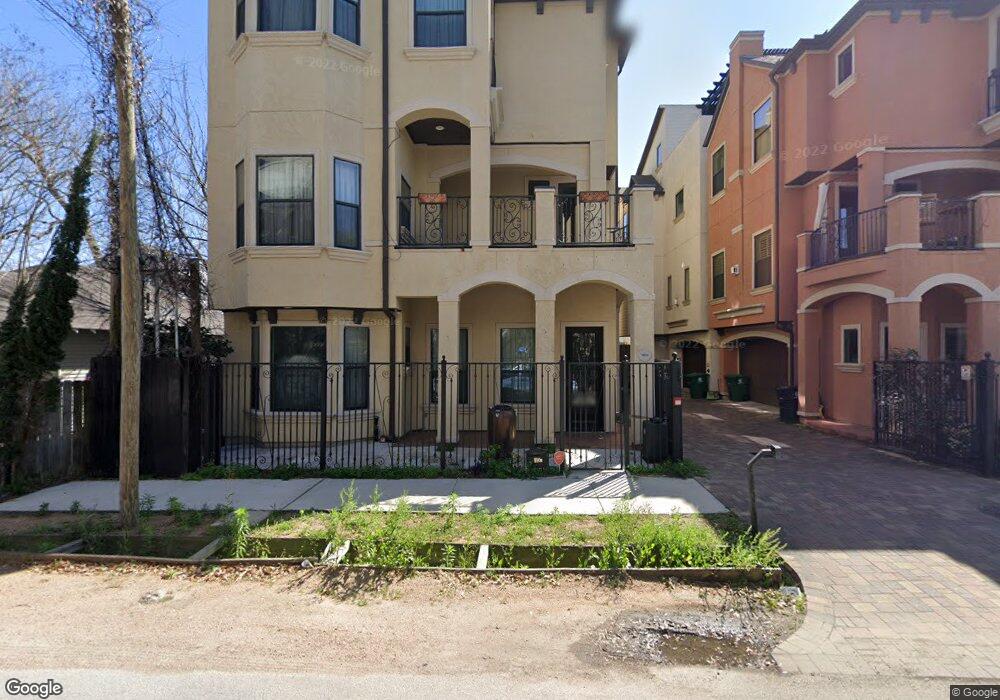
HIGHLY SOUGHT AFTER LOCATION overlooking Washington Ave! This 3 bed, 3.5 bath is full of LUXURY features -- RICH hardwoods & high ceilings throughout. Open family room w/ GORGEOUS fireplace. GOURMET GRANITE kitchen w/ SS appliances. A relaxing master retreat w/ sitting area, SPACIOUS walk-in closet & HUGE wrought iron terrace. Travertine dual vanities, whirlpool tub, & separate shower w/ tile back splash. Call today for a private showing!
Last Agent to Rent the Property
Keller Williams Realty The Woodlands License #0554530 Listed on: 06/19/2018
Last Renter's Agent
Nan & Company Properties - Corporate Office (Heights) License #0677424
| Date | Buyer | Sale Price | Title Company |
|---|---|---|---|
| Bachari Kafah | -- | None Available | |
| Bachari Kafah | -- | Commonwealth Title Of Housto |
| Date | Status | Borrower | Loan Amount |
|---|---|---|---|
| Previous Owner | Bachari Kafah | $342,980 | |
| Previous Owner | Bachari Kafah | $337,500 |
| Date | Event | Price | List to Sale | Price per Sq Ft |
|---|---|---|---|---|
| 12/30/2021 12/30/21 | Off Market | $3,300 | -- | -- |
| 11/15/2018 11/15/18 | Rented | $3,300 | 0.0% | -- |
| 10/16/2018 10/16/18 | Under Contract | -- | -- | -- |
| 06/25/2018 06/25/18 | For Rent | $3,300 | -- | -- |
| Year | Tax Paid | Tax Assessment Tax Assessment Total Assessment is a certain percentage of the fair market value that is determined by local assessors to be the total taxable value of land and additions on the property. | Land | Improvement |
|---|---|---|---|---|
| 2025 | $11,105 | $476,235 | $221,272 | $254,963 |
| 2024 | $11,105 | $530,717 | $197,980 | $332,737 |
| 2023 | $11,105 | $520,138 | $197,980 | $322,158 |
| 2022 | $10,635 | $483,000 | $197,980 | $285,020 |
| 2021 | $10,628 | $456,000 | $197,980 | $258,020 |
| 2020 | $10,655 | $440,000 | $197,980 | $242,020 |
| 2019 | $10,881 | $430,000 | $197,980 | $232,020 |
| 2018 | $10,172 | $402,000 | $139,751 | $262,249 |
| 2017 | $10,620 | $420,000 | $139,751 | $280,249 |
| 2016 | $11,556 | $457,000 | $139,751 | $317,249 |
| 2015 | $10,115 | $556,456 | $139,751 | $416,705 |
| 2014 | $10,115 | $393,472 | $139,751 | $253,721 |
Landlord's Agent in 2018
Jeremy Larkin
Keller Williams Realty The Woodlands
(832) 622-8100
574 Total Sales
Tenant's Agent in 2018
Ronnie Espling
Nan & Company Properties - Corporate Office (Heights)
(832) 696-2767
68 Total Sales
Source: Houston Association of REALTORS®
MLS Number: 86872283
APN: 1321450010001
Disclaimer: Certain information contained herein is derived from information provided by parties other than Homes.com. All information provided is deemed reliable, but is not guaranteed to be accurate and should be independently verified.
![]() Copyright 2026, Houston REALTORS® Information Service, Inc.
Copyright 2026, Houston REALTORS® Information Service, Inc.
The information provided is exclusively for consumers’ personal, non-commercial use, and may not be used for any purpose other than to identify prospective properties consumers may be interested in purchasing.
Information is deemed reliable but not guaranteed.
Ask me questions while you tour the home.