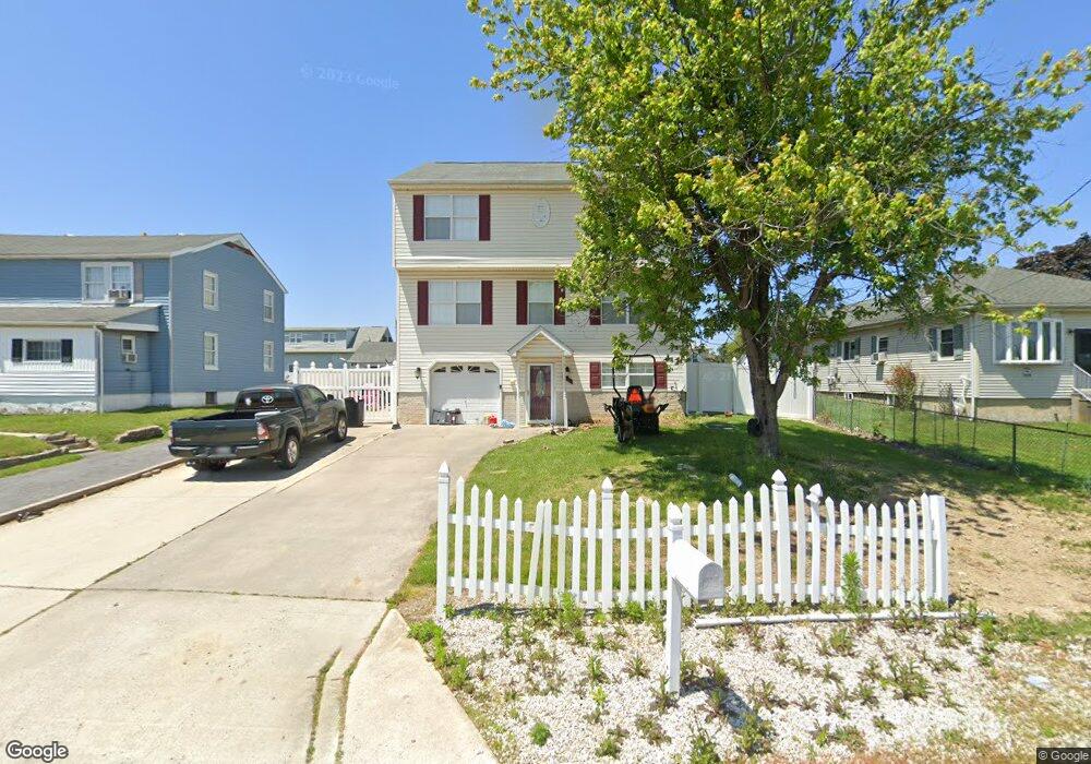
9118 Avenue C Sparrows Point, MD 21219
Estimated Value: $577,000 - $655,000
5
Beds
3
Baths
2,144
Sq Ft
$291/Sq Ft
Est. Value
About This Home
This home is located at 9118 Avenue C, Sparrows Point, MD 21219 and is currently estimated at $623,277, approximately $290 per square foot. 9118 Avenue C is a home located in Baltimore County with nearby schools including Chesapeake Terrace Elementary School, Sparrows Point Middle School, and Sparrows Point High School.
Ownership History
Date
Name
Owned For
Owner Type
Purchase Details
Closed on
Sep 4, 2018
Sold by
Vandgrifft Terry
Bought by
Bittner Richard G and Finch Ashley
Current Estimated Value
Home Financials for this Owner
Home Financials are based on the most recent Mortgage that was taken out on this home.
Original Mortgage
$384,899
Outstanding Balance
$334,014
Interest Rate
4.37%
Mortgage Type
FHA
Estimated Equity
$289,263
Purchase Details
Closed on
Dec 1, 2004
Sold by
Blue Water Properties Llc
Bought by
Vangrifft Terry
Purchase Details
Closed on
Jun 25, 2004
Sold by
Diven Ann F
Bought by
Blue Water Properties Llc
Create a Home Valuation Report for This Property
The Home Valuation Report is an in-depth analysis detailing your home's value as well as a comparison with similar homes in the area
Home Values in the Area
Average Home Value in this Area
Purchase History
We collect this data history from publicly available records. To have your information removed, we recommend requesting removal directly through your county’s website.
| Date | Buyer | Sale Price | Title Company |
|---|---|---|---|
| Bittner Richard G | $392,000 | Guaranteed Trust Title Llc | |
| Vangrifft Terry | $349,900 | -- | |
| Blue Water Properties Llc | $83,000 | -- | |
| Blue Water Properties Llc | $83,000 | -- |
Source: Public Records
Mortgage History
We collect this data history from publicly available records. To have your information removed, we recommend requesting removal directly through your county’s website.
| Date | Status | Borrower | Loan Amount |
|---|---|---|---|
| Open | Bittner Richard G | $384,899 |
Source: Public Records
Tax History
| Year | Tax Paid | Tax Assessment Tax Assessment Total Assessment is a certain percentage of the fair market value that is determined by local assessors to be the total taxable value of land and additions on the property. | Land | Improvement |
|---|---|---|---|---|
| 2025 | $6,427 | $488,167 | -- | -- |
| 2024 | $6,427 | $454,733 | $0 | $0 |
| 2023 | $2,980 | $421,300 | $142,000 | $279,300 |
| 2022 | $5,833 | $409,267 | $0 | $0 |
| 2021 | $5,602 | $397,233 | $0 | $0 |
| 2020 | $4,669 | $385,200 | $142,000 | $243,200 |
| 2019 | $4,336 | $357,733 | $0 | $0 |
| 2018 | $4,324 | $330,267 | $0 | $0 |
| 2017 | $3,907 | $302,800 | $0 | $0 |
| 2016 | $5,486 | $300,067 | $0 | $0 |
| 2015 | $5,486 | $297,333 | $0 | $0 |
| 2014 | $5,486 | $294,600 | $0 | $0 |
Source: Public Records
Map
Nearby Homes
- 9128 Todd Ave
- 9215 & 9217 Todd Ave
- 8820 Avenue B
- 7602 Bayside Ave
- 2100 Lodge Forest Dr
- 14 Thomas Ln
- 7428 Bay Front Rd
- 2215 Lodge Farm Rd
- 2219 Lodge Farm Rd
- 2408 Woodridge Rd
- 0 Lodge Farm Rd
- 7316A Hughes Ave
- 2513 Maple Rd
- 2434 Lodge Farm Rd
- 2412 Jarsey Ave
- 2636 Haddaway Rd
- 2634 Masseth Ave
- 2805 Willow Ave
- 2824 Shaws Rd
- 2524 Sycamore Ave
Your Personal Tour Guide
Ask me questions while you tour the home.