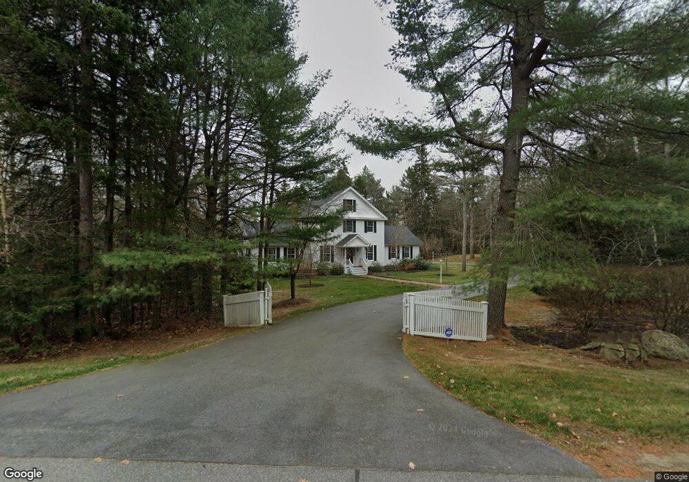
92 Kelsey Ridge Rd Freeport, ME 04032
Freeport AreaEstimated Value: $946,000 - $1,037,000
About This Home
This home is located at 92 Kelsey Ridge Rd, Freeport, ME 04032 and is currently estimated at $984,032, approximately $397 per square foot. 92 Kelsey Ridge Rd is a home located in Cumberland County with nearby schools including Morse Street School, Mast Landing School, and Freeport Middle School.
Ownership History
We collect this data history from publicly available records. To have your information removed, we recommend requesting removal directly through your county’s website.
Purchase Details
Purchase Details
Home Financials for this Owner
Home Financials are based on the most recent Mortgage that was taken out on this home.Home Values in the Area
Average Home Value in this Area
Purchase History
We collect this data history from publicly available records. To have your information removed, we recommend requesting removal directly through your county’s website.
| Date | Buyer | Sale Price | Title Company |
|---|---|---|---|
| -- | -- | ||
| -- | -- |
Mortgage History
We collect this data history from publicly available records. To have your information removed, we recommend requesting removal directly through your county’s website.
| Date | Status | Borrower | Loan Amount |
|---|---|---|---|
| Closed | $150,000 | ||
| Closed | $149,950 | ||
| Closed | $150,000 |
Tax History
We collect this data history from publicly available records. To have your information removed, we recommend requesting removal directly through your county’s website.
| Year | Tax Paid | Tax Assessment Tax Assessment Total Assessment is a certain percentage of the fair market value that is determined by local assessors to be the total taxable value of land and additions on the property. | Land | Improvement |
|---|---|---|---|---|
| 2025 | $10,313 | $744,600 | $245,100 | $499,500 |
| 2024 | $9,786 | $733,000 | $233,500 | $499,500 |
| 2023 | $8,865 | $644,700 | $212,100 | $432,600 |
| 2022 | $8,647 | $633,500 | $200,900 | $432,600 |
| 2021 | $8,457 | $633,500 | $200,900 | $432,600 |
| 2020 | $8,142 | $581,600 | $176,500 | $405,100 |
| 2019 | $7,832 | $547,700 | $166,500 | $381,200 |
| 2018 | $7,811 | $519,000 | $162,100 | $356,900 |
| 2017 | $7,457 | $498,800 | $158,400 | $340,400 |
| 2016 | $7,194 | $455,300 | $143,700 | $311,600 |
| 2015 | $7,172 | $426,900 | $131,300 | $295,600 |
| 2014 | $6,745 | $426,900 | $131,300 | $295,600 |
| 2013 | $6,589 | $415,700 | $127,600 | $288,100 |
Map
- 6 Newfield Rd
- 28 Cortland Rd
- 109 Pleasant Hill Rd
- 0 Prout Rd
- 0 Prout Rd
- 10 Radley Rd
- 4 Piebald Point Ridge
- 1260 Us Route 1
- 1294 U S 1
- 10 Cranberry Ridge Rd
- 10 Arrowhead Ridge Rd
- 19_8_1B Flying Point Rd
- 20 Acorn Ridge Rd
- 19_8_1A Flying Point Rd
- 38 Kings Timber Way
- 13 Chapel St
- 56 Bow St
- 88 Baker Rd
- 15 South St
- 43 Depot St Unit 206
- 84 Kelsey Ridge Rd
- 104 Kelsey Ridge Rd
- 63 Windsor Post Rd
- 91 Kelsey Ridge Rd
- 126 Kelsey Ridge Rd
- 127 Kelsey Ridge Rd
- 53 Windsor Post Rd
- 61 Kelsey Ridge Rd
- 130 Kelsey Ridge Rd
- 54 Kelsey Ridge Rd
- 129 Kelsey Ridge Rd
- 112 Kelsey Ridge Rd
- 34 Windsor Post Rd
- 34 Windsor Post Rd
- 37 Windsor Post Rd
- 20 Windsor Post Rd
- 140 Kelsey Ridge Rd
- 141 Kelsey Ridge Rd
- 34 Kelsey Ridge Rd
- 25 Windsor Post Rd
Ask me questions while you tour the home.