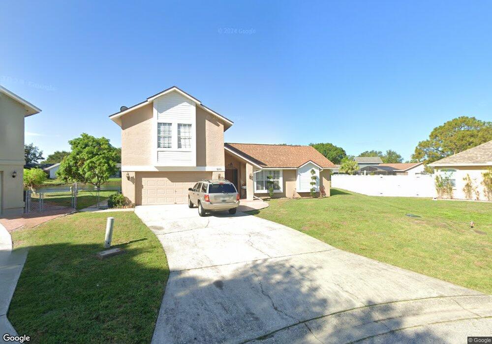
920 70th Dr E Sarasota, FL 34243
Estimated Value: $398,000 - $468,000
4
Beds
3
Baths
2,007
Sq Ft
$218/Sq Ft
Est. Value
About This Home
This home is located at 920 70th Dr E, Sarasota, FL 34243 and is currently estimated at $438,372, approximately $218 per square foot. 920 70th Dr E is a home located in Manatee County with nearby schools including Florine J. Abel Elementary School, Electa Lee Magnet Middle School, and Southeast High School.
Ownership History
Date
Name
Owned For
Owner Type
Purchase Details
Closed on
Jun 11, 2001
Sold by
Arnett Donald E and Arnett Rachel A
Bought by
Zeine Mayez G and Zeine Sabah I
Current Estimated Value
Home Financials for this Owner
Home Financials are based on the most recent Mortgage that was taken out on this home.
Original Mortgage
$125,000
Outstanding Balance
$47,406
Interest Rate
7.08%
Estimated Equity
$390,966
Purchase Details
Closed on
Mar 20, 1998
Sold by
King Ronald and King Joan Alicea
Bought by
Arnett Donald E and Arnett Rachel A
Home Financials for this Owner
Home Financials are based on the most recent Mortgage that was taken out on this home.
Original Mortgage
$82,500
Interest Rate
6.99%
Create a Home Valuation Report for This Property
The Home Valuation Report is an in-depth analysis detailing your home's value as well as a comparison with similar homes in the area
Home Values in the Area
Average Home Value in this Area
Purchase History
| Date | Buyer | Sale Price | Title Company |
|---|---|---|---|
| Zeine Mayez G | $160,000 | -- | |
| Arnett Donald E | $132,500 | -- |
Source: Public Records
Mortgage History
| Date | Status | Borrower | Loan Amount |
|---|---|---|---|
| Open | Zeine Mayez G | $125,000 | |
| Previous Owner | Arnett Donald E | $82,500 |
Source: Public Records
Tax History
| Year | Tax Paid | Tax Assessment Tax Assessment Total Assessment is a certain percentage of the fair market value that is determined by local assessors to be the total taxable value of land and additions on the property. | Land | Improvement |
|---|---|---|---|---|
| 2025 | $1,655 | $162,313 | -- | -- |
| 2023 | $1,624 | $153,145 | $0 | $0 |
| 2022 | $1,639 | $148,684 | $0 | $0 |
| 2021 | $1,568 | $144,353 | $0 | $0 |
| 2020 | $1,615 | $142,360 | $0 | $0 |
| 2019 | $1,585 | $139,159 | $0 | $0 |
| 2018 | $1,567 | $136,564 | $0 | $0 |
| 2017 | $1,442 | $133,755 | $0 | $0 |
| 2016 | $1,435 | $131,004 | $0 | $0 |
Source: Public Records
Map
Nearby Homes
- 6904 Pennsylvania Ave
- 813 Exmoor St
- 6860 Whitman Ct Unit 32B
- 927 Byron Ln Unit 13-B
- 965 Whitman Dr Unit 61
- 810 Mcarthur Ave
- 1219 70th Dr E
- 1147 Longfellow Rd Unit 157C
- 1143 Longfellow Rd
- 1190 Longfellow Way Unit 135-C
- 1125 Longfellow Way Unit 125B
- 705 Whitfield Ave
- 703 Whitfield Ave
- 844 Magellan Dr
- 1125 Danny Dr
- 836 Magellan Dr
- 7309 Meadowbrook Dr
- 1619 Suponic Ave
- 7320 Meadowbrook Dr
- 433 Whitfield Ave
- 923 70th Dr E
- 918 70th Dr E
- 916 70th Dr E
- 910 70th Dr E
- 917 70th Dr E
- 914 70th Dr E
- 908 70th Dr E
- 915 70th Dr E
- 912 70th Dr E
- 7115 Queen Palm Cir
- 7113 Queen Palm Cir
- 7117 Queen Palm Cir Unit Home
- 7111 Queen Palm Cir
- 913 70th Dr E
- 7109 Queen Palm Cir
- 906 70th Dr E
- 909 70th Dr E
- 911 70th Dr E
- 907 70th Dr E
- 7107 Queen Palm Cir
Your Personal Tour Guide
Ask me questions while you tour the home.