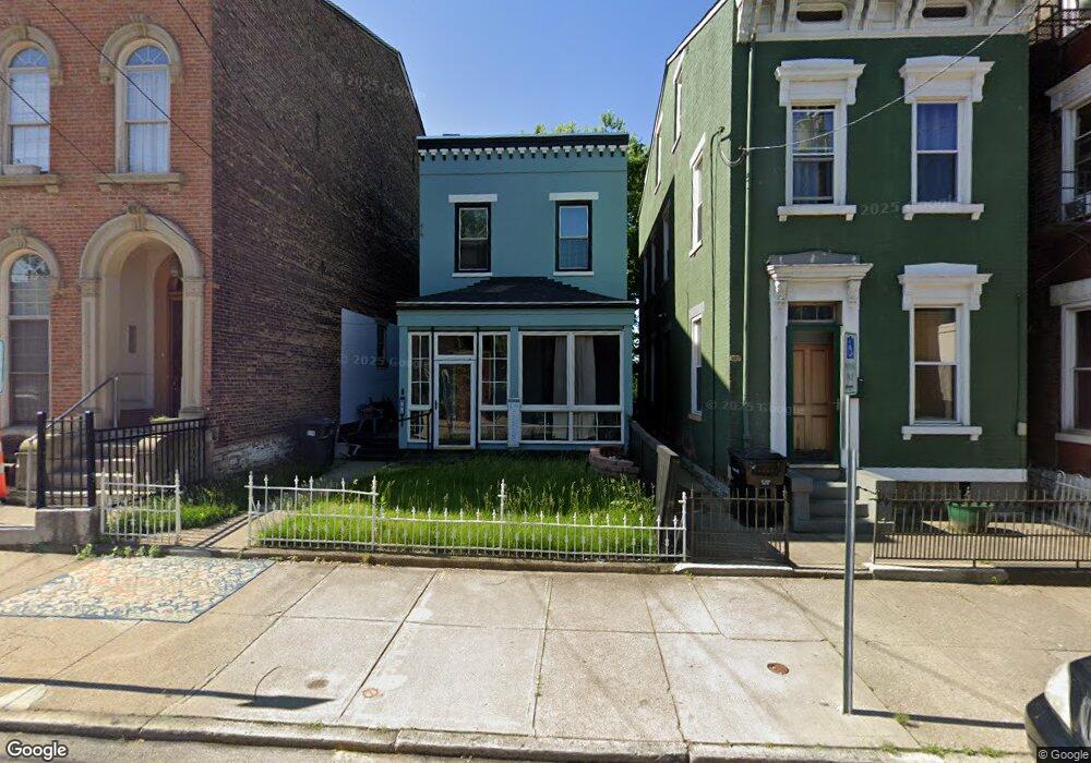
921 Findlay St Cincinnati, OH 45214
West End NeighborhoodEstimated Value: $176,499 - $242,000
3
Beds
1
Bath
1,560
Sq Ft
$131/Sq Ft
Est. Value
About This Home
This home is located at 921 Findlay St, Cincinnati, OH 45214 and is currently estimated at $203,875, approximately $130 per square foot. 921 Findlay St is a home located in Hamilton County with nearby schools including Hays-Porter School, Robert A. Taft Information Technology High School, and Gilbert A. Dater High School.
Ownership History
Date
Name
Owned For
Owner Type
Purchase Details
Closed on
Mar 7, 2002
Sold by
Tawwab Vonnie
Bought by
Tawwab Vonnie and Tawwab Saeed
Current Estimated Value
Home Financials for this Owner
Home Financials are based on the most recent Mortgage that was taken out on this home.
Original Mortgage
$32,750
Outstanding Balance
$16,260
Interest Rate
10.49%
Estimated Equity
$187,615
Purchase Details
Closed on
Jun 30, 2000
Sold by
Estate Of Rose Stockell
Bought by
Tawwab Vonnie
Create a Home Valuation Report for This Property
The Home Valuation Report is an in-depth analysis detailing your home's value as well as a comparison with similar homes in the area
Home Values in the Area
Average Home Value in this Area
Purchase History
| Date | Buyer | Sale Price | Title Company |
|---|---|---|---|
| Tawwab Vonnie | -- | -- | |
| Tawwab Vonnie | -- | -- |
Source: Public Records
Mortgage History
| Date | Status | Borrower | Loan Amount |
|---|---|---|---|
| Open | Tawwab Vonnie | $32,750 |
Source: Public Records
Tax History
| Year | Tax Paid | Tax Assessment Tax Assessment Total Assessment is a certain percentage of the fair market value that is determined by local assessors to be the total taxable value of land and additions on the property. | Land | Improvement |
|---|---|---|---|---|
| 2025 | $2,248 | $46,610 | $6,776 | $39,834 |
| 2024 | $2,183 | $46,610 | $6,776 | $39,834 |
| 2023 | $2,284 | $46,610 | $6,776 | $39,834 |
| 2022 | $496 | $15,985 | $3,728 | $12,257 |
| 2021 | $462 | $15,985 | $3,728 | $12,257 |
| 2020 | $491 | $15,985 | $3,728 | $12,257 |
| 2019 | $423 | $14,532 | $3,388 | $11,144 |
| 2018 | $425 | $14,532 | $3,388 | $11,144 |
| 2017 | $395 | $14,532 | $3,388 | $11,144 |
| 2016 | $324 | $13,553 | $3,364 | $10,189 |
| 2015 | $300 | $13,553 | $3,364 | $10,189 |
| 2014 | $303 | $13,553 | $3,364 | $10,189 |
| 2013 | $345 | $14,116 | $3,504 | $10,612 |
Source: Public Records
Map
Nearby Homes
- 912 Livingston St
- 923 Findlay St
- 924 Findlay St
- 1722 Freeman Ave
- 832 Livingston St
- 830 Livingston St
- 845 Charlotte St
- 1835 Baymiller St
- 818 Livingston St
- 815 Livingston St
- 830 York St
- 1142 Dayton St
- 1900 Colerain Ave
- 1916 Linn St
- 532 York St
- 1026 Dayton St
- 1114 York St
- 2008 Colerain Ave
- 1132 Dayton St
- 444 Dayton St
- 919 Findlay St
- 925 Findlay St
- 915 Findlay St
- 918 Livingston St
- 916 Livingston St
- 922 Findlay St
- 918 Findlay St
- 916 Findlay St
- 926 Findlay St
- 937 Findlay St
- 914 Findlay St
- 912 Findlay St
- 939 Findlay St
- 1721 Baymiller St
- 941 Findlay St
- 1805 Baymiller St
- 930 Findlay St
- 1803 Baymiller St
- 921 Charlotte St
- 915 Charlotte St
Your Personal Tour Guide
Ask me questions while you tour the home.