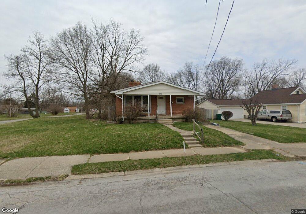
932 W Perrin Ave Springfield, OH 45506
Estimated Value: $80,000 - $97,000
About This Home
This home is located at 932 W Perrin Ave, Springfield, OH 45506 and is currently estimated at $89,153, approximately $72 per square foot. 932 W Perrin Ave is a home located in Clark County with nearby schools including Fulton Elementary School, Hayward Middle School, and Springfield High School.
Ownership History
We collect this data history from publicly available records. To have your information removed, we recommend requesting removal directly through your county’s website.
Purchase Details
Purchase Details
Home Financials for this Owner
Home Financials are based on the most recent Mortgage that was taken out on this home.Home Values in the Area
Average Home Value in this Area
Purchase History
We collect this data history from publicly available records. To have your information removed, we recommend requesting removal directly through your county’s website.
| Date | Buyer | Sale Price | Title Company |
|---|---|---|---|
| $15,000 | First American Title | ||
| $47,000 | -- |
Mortgage History
We collect this data history from publicly available records. To have your information removed, we recommend requesting removal directly through your county’s website.
| Date | Status | Borrower | Loan Amount |
|---|---|---|---|
| Previous Owner | $47,940 |
Tax History
We collect this data history from publicly available records. To have your information removed, we recommend requesting removal directly through your county’s website.
| Year | Tax Paid | Tax Assessment Tax Assessment Total Assessment is a certain percentage of the fair market value that is determined by local assessors to be the total taxable value of land and additions on the property. | Land | Improvement |
|---|---|---|---|---|
| 2025 | $795 | $23,920 | $2,600 | $21,320 |
| 2024 | $774 | $16,060 | $2,060 | $14,000 |
| 2023 | $774 | $16,060 | $2,060 | $14,000 |
| 2022 | $793 | $16,060 | $2,060 | $14,000 |
| 2021 | $774 | $14,470 | $1,860 | $12,610 |
| 2020 | $775 | $14,470 | $1,860 | $12,610 |
| 2019 | $777 | $14,470 | $1,860 | $12,610 |
| 2018 | $726 | $12,980 | $1,860 | $11,120 |
| 2017 | $725 | $12,979 | $1,859 | $11,120 |
| 2016 | $726 | $12,979 | $1,859 | $11,120 |
| 2015 | $741 | $12,979 | $1,859 | $11,120 |
| 2014 | $737 | $12,979 | $1,859 | $11,120 |
| 2013 | $730 | $12,979 | $1,859 | $11,120 |
Map
- 929 S Western Ave
- 1611 Springmont Ave
- 1002 S Yellow Springs St
- 1400 Innisfallen Ave
- 830 Dibert Ave
- 506 W Southern Ave
- 404 Rosewood Ave
- 1923 Portage Path
- 629 W Liberty St
- 410 W Liberty St
- 1014 Driscoll Ave
- 1217 Driscoll Ave
- 1024 W Pleasant St
- 525 W Clark St
- 337 Fair St Unit 339
- 1730 Damascus Ave
- 329 S Western Ave
- 709-711 W Mulberry St
- 204 W Johnny Lytle Ave
- 209 W Liberty St
- 1259 S Western Ave
- 1015 W Johnny Lytle Ave
- 1019 W Johnny Lytle Ave
- 1266 S Bell Ave
- 1010 W Perrin Ave
- 1002 W Perrin Ave
- 1014 W Perrin Ave
- 1020 W Perrin Ave
- 1025 W Johnny Lytle Ave
- 1018 W Perrin Ave
- 1217 S Western Ave
- 934 W Perrin Ave
- 1026 W Johnny Lytle Ave
- 1026 W Johnny Lytle Ave
- 1024 W Perrin Ave
- 1215 S Western Ave
- 919 W Johnny Lytle Ave
- 1210 S Bell Ave
- 1038 W Perrin Ave
- 1208 S Bell Ave
Ask me questions while you tour the home.