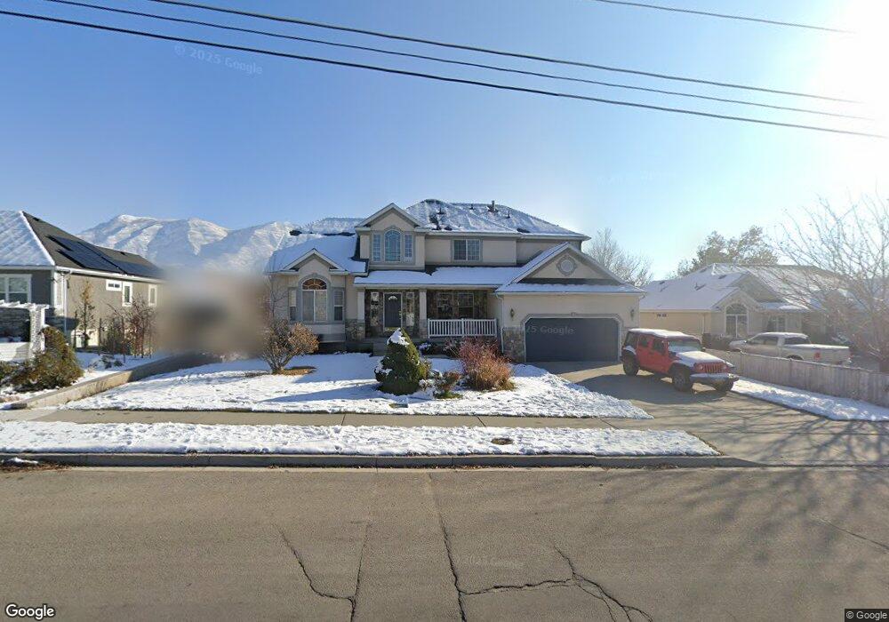
936 N 200 E American Fork, UT 84003
Estimated Value: $798,787 - $895,000
5
Beds
4
Baths
3,608
Sq Ft
$234/Sq Ft
Est. Value
About This Home
This home is located at 936 N 200 E, American Fork, UT 84003 and is currently estimated at $844,447, approximately $234 per square foot. 936 N 200 E is a home located in Utah County with nearby schools including Forbes Elementary School, American Fork Junior High School, and American Fork High School.
Ownership History
Date
Name
Owned For
Owner Type
Purchase Details
Closed on
Apr 27, 2020
Sold by
Smout Randall J and Smout Cori D
Bought by
Smout Randall and Smout Cori D
Current Estimated Value
Purchase Details
Closed on
May 19, 2009
Sold by
Miner Gordon
Bought by
Miner Gordon L and Miner Nancy J
Purchase Details
Closed on
Jan 28, 1999
Sold by
Ivory Homes
Bought by
Smout Randall J and Smout Cori D
Home Financials for this Owner
Home Financials are based on the most recent Mortgage that was taken out on this home.
Original Mortgage
$200,000
Outstanding Balance
$46,892
Interest Rate
6.63%
Estimated Equity
$797,555
Create a Home Valuation Report for This Property
The Home Valuation Report is an in-depth analysis detailing your home's value as well as a comparison with similar homes in the area
Home Values in the Area
Average Home Value in this Area
Purchase History
| Date | Buyer | Sale Price | Title Company |
|---|---|---|---|
| Smout Randall | -- | None Available | |
| Miner Gordon L | -- | Accommodation | |
| Smout Randall J | -- | Guardian Title Insurance |
Source: Public Records
Mortgage History
| Date | Status | Borrower | Loan Amount |
|---|---|---|---|
| Open | Smout Randall J | $200,000 |
Source: Public Records
Tax History
| Year | Tax Paid | Tax Assessment Tax Assessment Total Assessment is a certain percentage of the fair market value that is determined by local assessors to be the total taxable value of land and additions on the property. | Land | Improvement |
|---|---|---|---|---|
| 2025 | $3,638 | $436,590 | -- | -- |
| 2024 | $3,638 | $404,195 | $0 | $0 |
| 2023 | $3,501 | $412,390 | $0 | $0 |
| 2022 | $3,911 | $454,685 | $0 | $0 |
| 2021 | $3,387 | $615,000 | $152,300 | $462,700 |
| 2020 | $3,205 | $564,400 | $136,000 | $428,400 |
| 2019 | $3,063 | $557,900 | $132,300 | $425,600 |
| 2018 | $2,872 | $500,100 | $121,300 | $378,800 |
| 2017 | $2,551 | $239,800 | $0 | $0 |
| 2016 | $2,746 | $239,800 | $0 | $0 |
| 2015 | $2,653 | $219,835 | $0 | $0 |
| 2014 | $2,665 | $217,855 | $0 | $0 |
Source: Public Records
Map
Nearby Homes
- 822 N 150 E Unit 5
- 780 N 100 E
- 4650 W Magnolia Drive Dr Unit 8
- 10238 N 6530 W Unit 15
- 941 E S Ellens St Lot 3 St N Unit LOT 3
- 5277 N 11200 W Unit 4
- 5284 N 11200 W Unit 3
- 925 E Ellens St E Unit LOT 2
- 603 S 370 E
- 10211 N 6530 W Unit 3
- 234 W 1080 N
- 0 N Nob Hill Dr Unit 4
- 952 N 400 E
- 1082 N 350 E
- 183 E 760 St N
- 68 E 1250 N
- 1309 N 200 E
- 691 N 400 E Unit A & B Units
- 691 N 400 E Unit A & B
- 691 N 400 E
Your Personal Tour Guide
Ask me questions while you tour the home.