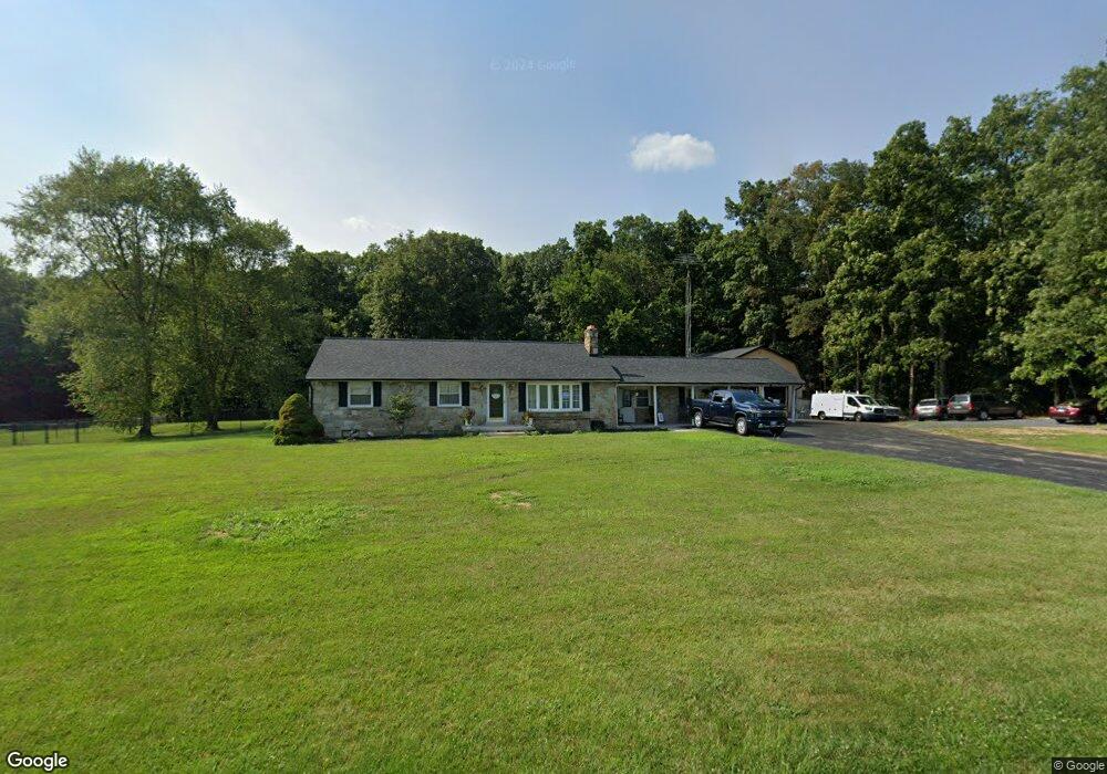
94 Plunkert Rd Littlestown, PA 17340
Estimated Value: $357,048 - $386,000
3
Beds
2
Baths
2,160
Sq Ft
$174/Sq Ft
Est. Value
About This Home
This home is located at 94 Plunkert Rd, Littlestown, PA 17340 and is currently estimated at $375,762, approximately $173 per square foot. 94 Plunkert Rd is a home located in Adams County with nearby schools including Rolling Acres El School, Maple Avenue Middle School, and Littlestown Senior High School.
Ownership History
Date
Name
Owned For
Owner Type
Purchase Details
Closed on
Oct 17, 2022
Sold by
Buckley Robert L
Bought by
Buckley David L and Buckley Steven A
Current Estimated Value
Home Financials for this Owner
Home Financials are based on the most recent Mortgage that was taken out on this home.
Original Mortgage
$175,000
Outstanding Balance
$168,378
Interest Rate
6.02%
Mortgage Type
New Conventional
Estimated Equity
$207,384
Purchase Details
Closed on
Jan 1, 1961
Bought by
Buckley Robert L and Buckley Mary M
Create a Home Valuation Report for This Property
The Home Valuation Report is an in-depth analysis detailing your home's value as well as a comparison with similar homes in the area
Purchase History
| Date | Buyer | Sale Price | Title Company |
|---|---|---|---|
| Buckley David L | $285,000 | -- | |
| Buckley Robert L | $1,400 | -- |
Source: Public Records
Mortgage History
| Date | Status | Borrower | Loan Amount |
|---|---|---|---|
| Open | Buckley David L | $175,000 |
Source: Public Records
Tax History
| Year | Tax Paid | Tax Assessment Tax Assessment Total Assessment is a certain percentage of the fair market value that is determined by local assessors to be the total taxable value of land and additions on the property. | Land | Improvement |
|---|---|---|---|---|
| 2025 | $3,852 | $233,300 | $50,000 | $183,300 |
| 2024 | $4,163 | $233,300 | $50,000 | $183,300 |
| 2023 | $4,079 | $233,300 | $50,000 | $183,300 |
| 2022 | $4,049 | $233,300 | $50,000 | $183,300 |
| 2021 | $3,938 | $233,300 | $50,000 | $183,300 |
| 2020 | $3,583 | $233,300 | $50,000 | $183,300 |
| 2019 | $2,338 | $233,300 | $50,000 | $183,300 |
| 2018 | $3,713 | $233,300 | $50,000 | $183,300 |
| 2017 | $3,597 | $233,300 | $50,000 | $183,300 |
| 2016 | -- | $233,300 | $50,000 | $183,300 |
| 2015 | -- | $233,300 | $50,000 | $183,300 |
| 2014 | -- | $233,300 | $50,000 | $183,300 |
Source: Public Records
Map
Nearby Homes
- 105 Saint Johns Rd W
- 464 Locust Ln
- 5160 Baltimore Pike Unit 3
- 620 Saint Johns Rd
- 0 Locust Dr Unit PAAD2015910
- 153 Stoners Cir
- 240 Amanda Dr Unit 18
- 0 Hershey Rd Unit PALA2058618
- 780 White Hall Rd
- 20 Stedtle Ave
- 1002 Frederick Pike Unit 4
- 19 Stayman Way Unit 64
- 1014 Frederick Pike Unit 5
- 2975 Baltimore Pike
- 64 N Gala Unit 400
- 2226 Harney Rd Unit 2
- 162 Newark St
- 2085 Harney Rd
- 102 N Queen St
- 45 James Ave
- 150 Plunkert Rd
- 156 Plunkert Rd
- 172 Plunkert Rd
- 4154 Baltimore Pike
- 4130 Baltimore Pike
- 4219 Baltimore Pike
- 30 Mud College Rd Unit 2
- 50 Mud College Rd Unit 3
- Lot #2 407 Baltimore Pike
- 4075 Baltimore Pike Unit 2
- 4075 Baltimore Pike Unit 1
- 4075 Baltimore Pike
- 59 Mud College Rd
- 136 Mud College Rd
- 4006 Baltimore Pike
- 4002 Baltimore Pike
- 4006 Baltimore Pike (Bowers Road)
- 324 Plunkert Rd Unit 8
- 325 Plunkert Rd
- 4003 Baltimore Pike
Your Personal Tour Guide
Ask me questions while you tour the home.