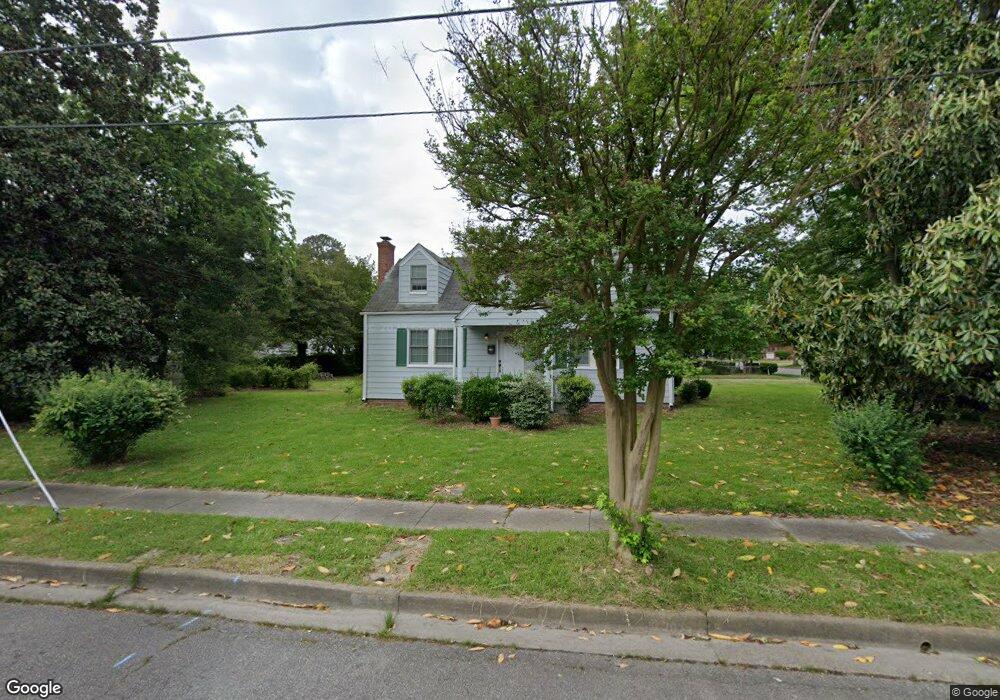
945 Albert Ave Norfolk, VA 23513
Coronado NeighborhoodEstimated Value: $264,000 - $329,000
4
Beds
2
Baths
1,454
Sq Ft
$210/Sq Ft
Est. Value
About This Home
This home is located at 945 Albert Ave, Norfolk, VA 23513 and is currently estimated at $305,838, approximately $210 per square foot. 945 Albert Ave is a home located in Norfolk City with nearby schools including Frances E. Willard Model Elementary School, Norview Middle School, and Norview High School.
Ownership History
Date
Name
Owned For
Owner Type
Purchase Details
Closed on
May 5, 2016
Sold by
Brown Laura Gray
Bought by
Handforth Justin A
Current Estimated Value
Home Financials for this Owner
Home Financials are based on the most recent Mortgage that was taken out on this home.
Original Mortgage
$166,822
Outstanding Balance
$131,533
Interest Rate
3.37%
Mortgage Type
FHA
Estimated Equity
$174,305
Create a Home Valuation Report for This Property
The Home Valuation Report is an in-depth analysis detailing your home's value as well as a comparison with similar homes in the area
Home Values in the Area
Average Home Value in this Area
Purchase History
We collect this data history from publicly available records. To have your information removed, we recommend requesting removal directly through your county’s website.
| Date | Buyer | Sale Price | Title Company |
|---|---|---|---|
| Handforth Justin A | $169,900 | Attorney |
Source: Public Records
Mortgage History
We collect this data history from publicly available records. To have your information removed, we recommend requesting removal directly through your county’s website.
| Date | Status | Borrower | Loan Amount |
|---|---|---|---|
| Open | Handforth Justin A | $166,822 |
Source: Public Records
Tax History
| Year | Tax Paid | Tax Assessment Tax Assessment Total Assessment is a certain percentage of the fair market value that is determined by local assessors to be the total taxable value of land and additions on the property. | Land | Improvement |
|---|---|---|---|---|
| 2025 | $3,423 | $278,300 | $94,500 | $183,800 |
| 2024 | $3,199 | $260,100 | $94,500 | $165,600 |
| 2023 | $3,066 | $245,300 | $94,500 | $150,800 |
| 2022 | $2,759 | $220,700 | $69,900 | $150,800 |
| 2021 | $2,570 | $205,600 | $66,600 | $139,000 |
| 2020 | $2,364 | $189,100 | $55,000 | $134,100 |
| 2019 | $2,225 | $178,000 | $50,000 | $128,000 |
| 2018 | $2,193 | $175,400 | $50,000 | $125,400 |
| 2017 | $2,008 | $174,600 | $50,000 | $124,600 |
| 2016 | $1,978 | $186,800 | $60,000 | $126,800 |
| 2015 | $2,148 | $186,800 | $60,000 | $126,800 |
| 2014 | $2,148 | $186,800 | $60,000 | $126,800 |
Source: Public Records
Map
Nearby Homes
- 964 Marietta Ave
- 974 Philpotts Rd
- 907 Albert Ave
- 920 Widgeon Rd
- 914 Widgeon Rd
- 6434 Partridge St
- 6618 Palem Rd
- 6634 Whitehorn Dr
- 6423 Dove St
- 6429 Clare Rd
- 852 Philpotts Rd
- 6369 Devonshire Rd
- 6372 Palem Rd
- 1077 Kittrell St
- 1082 Clements Ave
- 921 Hugo St
- 601 Thole St
- 1058 Ivaloo St
- 1236 Curie Ct
- 7431 Tyndale Ct
- 951 Albert Ave
- LOT D Pierce St
- 948 Marietta Ave
- 946 Marietta Ave
- 937 Albert Ave
- 6613 Pierce St
- 950 Marietta Ave
- 940 Marietta Ave
- 955 Albert Ave
- 944 Albert Ave
- 948 Albert Ave
- 954 Marietta Ave
- 935 Albert Ave
- 938 Marietta Ave
- 952 Albert Ave
- 936 Albert Ave
- 956 Marietta Ave
- 936 Marietta Ave
- 933 Albert Ave
- 956 Albert Ave
Your Personal Tour Guide
Ask me questions while you tour the home.