D
Seller's Agent in 2025
Donald Denault
Landmark, REALTORS®
(413) 426-3207
3 in this area
11 Total Sales
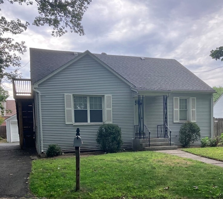


Price Improvement !!!!Outstanding home located in the Atwater Ter neighborhood!! Spacious, open floor plan offers Updated kitchen, gleaming hard wood floors and stainless steel appliances. Beautiful first floor updated bathroom even includes a soaking tub! Second floor offers an oversized bedroom and full bath with direct outside acess. Downcellar presents several different sized rooms and storage galore! Step out back on to a spacious deck and stoned in grill area . Make you appoinment today!
| Date | Type | Sale Price | Title Company |
|---|---|---|---|
| Quit Claim Deed | -- | -- | |
| Quit Claim Deed | $259,000 | -- | |
| Quit Claim Deed | -- | None Available | |
| Deed | -- | -- | |
| Deed | $97,500 | -- |
| Date | Status | Loan Amount | Loan Type |
|---|---|---|---|
| Previous Owner | $160,987 | New Conventional | |
| Previous Owner | $73,000 | No Value Available | |
| Previous Owner | $78,000 | Purchase Money Mortgage |
| Date | Event | Price | List to Sale | Price per Sq Ft |
|---|---|---|---|---|
| 11/25/2025 11/25/25 | Sold | $259,000 | 0.0% | $143 / Sq Ft |
| 11/03/2025 11/03/25 | Pending | -- | -- | -- |
| 10/31/2025 10/31/25 | Off Market | $259,000 | -- | -- |
| 10/18/2025 10/18/25 | Pending | -- | -- | -- |
| 10/15/2025 10/15/25 | Price Changed | $259,000 | 0.0% | $143 / Sq Ft |
| 10/15/2025 10/15/25 | For Sale | $259,000 | -7.5% | $143 / Sq Ft |
| 10/01/2025 10/01/25 | Pending | -- | -- | -- |
| 09/11/2025 09/11/25 | Price Changed | $279,900 | -3.1% | $154 / Sq Ft |
| 08/29/2025 08/29/25 | For Sale | $289,000 | -- | $159 / Sq Ft |
| Year | Tax Paid | Tax Assessment Tax Assessment Total Assessment is a certain percentage of the fair market value that is determined by local assessors to be the total taxable value of land and additions on the property. | Land | Improvement |
|---|---|---|---|---|
| 2025 | $4,176 | $266,300 | $50,800 | $215,500 |
| 2024 | $4,107 | $255,700 | $50,800 | $204,900 |
| 2023 | $4,261 | $249,900 | $48,300 | $201,600 |
| 2022 | $4,306 | $228,800 | $48,300 | $180,500 |
| 2021 | $3,895 | $206,100 | $43,900 | $162,200 |
| 2020 | $3,900 | $199,700 | $43,900 | $155,800 |
| 2019 | $4,062 | $206,400 | $43,900 | $162,500 |
| 2018 | $3,735 | $189,800 | $43,900 | $145,900 |
| 2017 | $3,366 | $171,200 | $41,500 | $129,700 |
| 2016 | $3,236 | $164,600 | $41,500 | $123,100 |
| 2015 | $3,285 | $167,000 | $41,500 | $125,500 |
D
Seller's Agent in 2025
Donald Denault
Landmark, REALTORS®
(413) 426-3207
3 in this area
11 Total Sales

Buyer's Agent in 2025
Amanda Rodriguez
Lock and Key Realty Inc.
(413) 221-3269
2 in this area
34 Total Sales
Source: MLS Property Information Network (MLS PIN)
MLS Number: 73423288
APN: SPRI-012075-000000-000061
Disclaimer: Certain information contained herein is derived from information provided by parties other than Homes.com. All information provided is deemed reliable, but is not guaranteed to be accurate and should be independently verified.
![]() The property listing data and information, or the Images, set forth herein were provided to MLS Property Information Network, Inc. from third party sources, including sellers, lessors and public records, and were compiled by MLS Property Information Network, Inc. The property listing data and information, and the Images, are for the personal, non-commercial use of consumers having a good faith interest in purchasing or leasing listed properties of the type displayed to them and may not be used for any purpose other than to identify prospective properties which such consumers may have a good faith interest in purchasing or leasing. MLS Property Information Network, Inc. and its subscribers disclaim any and all representations and warranties as to the accuracy of the property listing data and information, or as to the accuracy of any of the Images, set forth herein.
The property listing data and information, or the Images, set forth herein were provided to MLS Property Information Network, Inc. from third party sources, including sellers, lessors and public records, and were compiled by MLS Property Information Network, Inc. The property listing data and information, and the Images, are for the personal, non-commercial use of consumers having a good faith interest in purchasing or leasing listed properties of the type displayed to them and may not be used for any purpose other than to identify prospective properties which such consumers may have a good faith interest in purchasing or leasing. MLS Property Information Network, Inc. and its subscribers disclaim any and all representations and warranties as to the accuracy of the property listing data and information, or as to the accuracy of any of the Images, set forth herein.
Ask me questions while you tour the home.