NOT LISTED FOR SALE

9554 S North Hulbert Rd Hulbert, MI 49748

Estimated Value: $41,000 - $200,000

10 Acres
$10,711 Price per Acre
435,600 Sq Ft Lot

Last Sold January 21, 2025

Last sale price $38,500

Est. 178% increase in value since last sale

Current estimated payment $591/month

46 Days on Market

About This Lot

As of January 2025

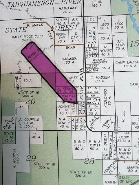
This 10 acres parcel offers it all for the outdoor enthusiast, from excellent deer hunting, to fishing and recreation with the East Branch and Tahquamenon River located down the road a couple miles accessed by boat launch at Kalio's Landing.S North Hulbert Road is paved to site and has electric. The snowmobile trail is located near this location and is close to Hulbert for nightly entertainment. The land has been cleared with a building site established. The parcel is a square 660' x 660' parcel and goes to the ridge back of property. The land is high & dry and slopes upward to ridge back of property. Come see this property today, it's worth the trip to view it.

Last Agent to Sell the Property

Janet Maki

COLDWELL BANKER SCHMIDT - CEDARVILLE Listed on: 11/02/2024

COLDWELL BANKER SCHMIDT - CEDARVILLE

Last Buyer's Agent

Rob Sullivan

Northern Michigan Land Brokers Marquette LLC

Property Details

Property Type

Land

Lot Details

0

Listing Details

  • Cleared Acreage: 6 - 10 Acres
  • Directions: From Newberry at intersection M-28 & M-123, turn left and go approximately 17 miles to South Hulbert Rd. Turn Left and go 1.3 miles and turn Left and go 4 miles just past Apple Lane. Parcel is located to the left at 9554 S North Hulbert Rd. Sign Posted
  • Financial Info Electric: Available
  • Land Info Mineral Rights: unknown
  • Listing Member Name: Janet K Maki
  • Prop. Type: C
  • Co Selling Member Short Id: 0295
  • Selling Office Short Id: 0103
  • Tax Year: 2024
  • Lot Description Waterfront: No
  • Master Plan Zoning: yes
  • Special Features: None
  • Property Sub Type: LotsLands

Exterior Features

  • Access: County Road, Paved
  • Water View: No

Schools

  • Junior High Dist: Tahquamenon

Lot Info

  • Lot Description: Wooded Lot
  • Lot Size: 660 x 660
  • Estimated Number of Acres: 10.00

Rental Info

  • Lease V: 9,200

Range of Values:

--
Value Increase
--
Percent Increase
--
Adjusted for Inflation
Collateral Analytics

Collateral Analytics Collateral Analytics AVMs (Automated Valuation Model) employ a number of statistical approaches combined with neighborhood-specific comparable selection guarantees the most up-to-date and precise valuations.

Not Available

Collateral Analytics does not have data for the current month. Please view the chart for historical values.

ICE

ICE Mortgage Technology ICE Mortgage Technology’s AVM (Automated Valuation Model) is a state-of-the-art online residential property valuation tool that provides a quick and accurate estimate of the value of almost any home in the U.S.

Not Available

ICE Mortgage Technology does not have data for the current month. Please view the chart for historical values.

First American

First American First American Data & Analytics’ next-generation AVM combines unrivaled data assets with a blended ensemble of valuation models to produce highly accurate, reliable valuations you can trust.

Not Available

First American does not have data for the current month. Please view the chart for historical values.

Quantarium

Quantarium Quantarium’s valuation service, repeatedly proven the industry’s most accurate and comprehensive, is supercharged with a self-learning and auto-tuning AI engine that continually becomes smarter and more accurate as it processes daily inputs from the industry’s leading RE data lake.

Not Available

Quantarium does not have data for the current month. Please view the chart for historical values.

Average Value
Not Available
List Price
Sold Price
Create a Home Valuation Report for This Property
The Home Valuation Report is an in-depth analysis detailing your home's value as well as a comparison with similar homes in the area

Property History

Date Event Price List to Sale Price per Sq Ft
01/21/2025 01/21/25 Sold $38,500 -10.5% --
12/18/2024 12/18/24 Pending -- -- --
11/02/2024 11/02/24 For Sale $43,000 -- --

Tax History Compared to Growth

Source: Public Records

Tax History

Year Tax Paid Tax Assessment Tax Assessment Total Assessment is a certain percentage of the fair market value that is determined by local assessors to be the total taxable value of land and additions on the property. Land Improvement
2025 $441 $11,500 $0 $0
2024 $294 $9,200 $0 $0
2023 $186 $8,000 $0 $0
2022 $186 $9,400 $0 $0
2021 $171 $6,000 $0 $0
2020 $168 $6,000 $0 $0
2019 $172 $6,000 $0 $0
2018 $122 $6,000 $0 $0
2017 $120 $6,000 $0 $0
2016 $119 $5,800 $0 $0
2011 $109 $10,193 $0 $0
Source: Public Records

Agents Affiliated with this Home

  • Section Image
  • Section Image
See All Agents

Map