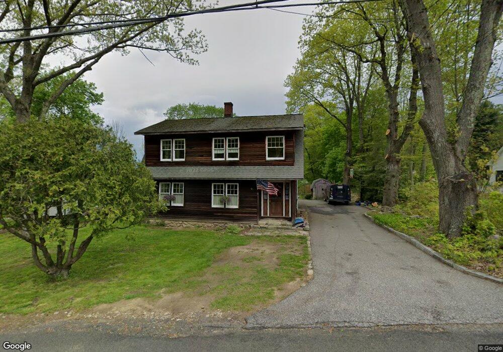
96 Upper Bogue Rd Harwinton, CT 06791
Estimated Value: $354,000 - $427,000
3
Beds
2
Baths
2,265
Sq Ft
$172/Sq Ft
Est. Value
About This Home
This home is located at 96 Upper Bogue Rd, Harwinton, CT 06791 and is currently estimated at $388,690, approximately $171 per square foot. 96 Upper Bogue Rd is a home located in Litchfield County with nearby schools including Harwinton Consolidated School, Har-Bur Middle School, and Lewis S. Mills High School.
Ownership History
Date
Name
Owned For
Owner Type
Purchase Details
Closed on
Jun 28, 1991
Sold by
Bowski Doreen and Smigel Lori
Bought by
Martinelli Joseph and Martinelli Cheryl
Current Estimated Value
Create a Home Valuation Report for This Property
The Home Valuation Report is an in-depth analysis detailing your home's value as well as a comparison with similar homes in the area
Home Values in the Area
Average Home Value in this Area
Purchase History
| Date | Buyer | Sale Price | Title Company |
|---|---|---|---|
| Martinelli Joseph | $95,000 | -- |
Source: Public Records
Mortgage History
| Date | Status | Borrower | Loan Amount |
|---|---|---|---|
| Open | Martinelli Joseph | $192,000 | |
| Closed | Martinelli Joseph | $183,000 | |
| Closed | Martinelli Joseph | $175,000 |
Source: Public Records
Tax History
| Year | Tax Paid | Tax Assessment Tax Assessment Total Assessment is a certain percentage of the fair market value that is determined by local assessors to be the total taxable value of land and additions on the property. | Land | Improvement |
|---|---|---|---|---|
| 2025 | $4,792 | $208,330 | $49,140 | $159,190 |
| 2024 | $4,771 | $208,330 | $49,140 | $159,190 |
| 2023 | $4,737 | $162,220 | $35,100 | $127,120 |
| 2022 | $4,623 | $162,220 | $35,100 | $127,120 |
| 2021 | $4,656 | $162,220 | $35,100 | $127,120 |
| 2020 | $4,542 | $162,220 | $35,100 | $127,120 |
| 2019 | $4,542 | $162,220 | $35,100 | $127,120 |
| 2018 | $4,475 | $159,830 | $34,200 | $125,630 |
| 2017 | $4,443 | $159,830 | $34,200 | $125,630 |
| 2016 | $4,443 | $159,830 | $34,200 | $125,630 |
| 2015 | $4,363 | $159,830 | $34,200 | $125,630 |
| 2014 | $4,299 | $159,830 | $34,200 | $125,630 |
Source: Public Records
Map
Nearby Homes
- 68 Thomaston Rd
- 505 Harwinton Ave Unit 20
- 0 Clearview Ave Unit 24158105
- 112 Linden St
- 364 Park Ave
- 152 Davis Rd
- 71 Arthur St Unit 1
- 14 Hannah Way
- 23 Hannah Way
- 83 Birge St
- 29 Elton St
- 264 S Main St
- 67 E Litchfield Rd S
- Lot 2 Birch Hill Rd
- 151 Highview Dr
- 21 Sunrise Dr
- 185 Oak Meadow Ln
- 68 Wilson Ave Unit 103
- 68 Wilson Ave Unit 105
- 19 Harwinton Ave
- 92 Upper Bogue Rd
- 99 Upper Bogue Rd
- 99 Bogue Rd
- 93 Upper Bogue Rd
- 103 Upper Bogue Rd
- 11 Community Rd
- 83 Upper Bogue Rd
- 89 Upper Bogue Rd
- 89 Bogue Rd
- 234 Scoville Hill Rd
- 106 Upper Bogue Rd
- 106 Bogue Rd
- 13 Community Rd
- 238 Scoville Hill Rd
- 83 Bogue Rd
- 14 Community Rd
- 79 Upper Bogue Rd
- 79 Bogue Rd
- 233 Scoville Hill Rd
- 82 Upper Bogue Rd
Your Personal Tour Guide
Ask me questions while you tour the home.