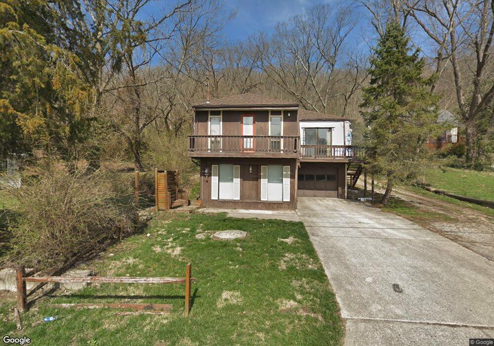
9622 Brower Rd North Bend, OH 45052
Estimated Value: $176,822 - $252,000
2
Beds
2
Baths
1,444
Sq Ft
$145/Sq Ft
Est. Value
About This Home
This home is located at 9622 Brower Rd, North Bend, OH 45052 and is currently estimated at $209,706, approximately $145 per square foot. 9622 Brower Rd is a home located in Hamilton County with nearby schools including Charles T. Young Elementary School, Taylor Middle School, and Taylor High School.
Ownership History
Date
Name
Owned For
Owner Type
Purchase Details
Closed on
Apr 14, 2017
Sold by
Mussman Rose
Bought by
Raphael Jerome T
Current Estimated Value
Purchase Details
Closed on
Apr 11, 2017
Sold by
Stowe Ann Raphael and Stowe Mark E
Bought by
Raphael Joseph D
Purchase Details
Closed on
Apr 10, 2017
Sold by
Raphael Thomas J and Raphael Linda A
Bought by
Raphael Joseph D
Purchase Details
Closed on
Jul 13, 1992
Sold by
Rountree Daniel J
Bought by
Raphael Joseph A
Create a Home Valuation Report for This Property
The Home Valuation Report is an in-depth analysis detailing your home's value as well as a comparison with similar homes in the area
Home Values in the Area
Average Home Value in this Area
Purchase History
| Date | Buyer | Sale Price | Title Company |
|---|---|---|---|
| Raphael Jerome T | -- | None Available | |
| Raphael Joseph D | -- | None Available | |
| Raphael Joseph D | -- | None Available | |
| Raphael Joseph D | -- | None Available | |
| Raphael Joseph A | $59,900 | -- |
Source: Public Records
Tax History
| Year | Tax Paid | Tax Assessment Tax Assessment Total Assessment is a certain percentage of the fair market value that is determined by local assessors to be the total taxable value of land and additions on the property. | Land | Improvement |
|---|---|---|---|---|
| 2025 | $2,331 | $43,201 | $6,125 | $37,076 |
| 2024 | $2,324 | $43,201 | $6,125 | $37,076 |
| 2023 | $2,098 | $43,201 | $6,125 | $37,076 |
| 2022 | $2,454 | $39,677 | $6,073 | $33,604 |
| 2021 | $2,625 | $39,677 | $6,073 | $33,604 |
| 2020 | $2,399 | $39,677 | $6,073 | $33,604 |
| 2019 | $2,188 | $33,341 | $5,103 | $28,238 |
| 2018 | $2,105 | $33,341 | $5,103 | $28,238 |
| 2017 | $2,005 | $33,341 | $5,103 | $28,238 |
| 2016 | $2,211 | $37,429 | $5,460 | $31,969 |
| 2015 | $2,096 | $37,429 | $5,460 | $31,969 |
| 2014 | $2,118 | $37,429 | $5,460 | $31,969 |
| 2013 | $1,938 | $34,979 | $5,103 | $29,876 |
Source: Public Records
Map
Nearby Homes
- 2545 Cliff Rd
- 9629 Mount Nebo Rd
- 9568 Mount Nebo Rd
- 239 S Miami Ave
- TBD Do Not Use
- 101 E State Rd
- 104 W Laird St
- 122 Spring St
- 1540 Autumn Ridge Dr
- 221 N Miami Ave
- 550 Aston View Ln
- 1522 Autumn Ridge Dr
- 311 N Miami Ave
- 310 Spring St
- 1759 Barons Cove
- 8783 Bridgetown Rd
- 1218 Breckenridge Ln
- 8757 Bridgetown Rd
- 633 Rivershore Dr
- 3889 Bear Ln
- 9618 Brower Rd
- 9638 Brower Rd
- 9614 Brower Rd
- 9608 Brower Rd
- 9644 Brower Rd
- 9604 Brower Rd
- 9648 Brower Rd
- 9592 Brower Rd
- 9658 Brower Rd
- 2510 Rittenhouse Rd
- 9586 Brower Rd
- 9580 Brower Rd
- 9582 Brower Rd
- 9576 Brower Rd
- 2615 Cliff Rd
- 2525 Cliff Rd
- 9554 Brower Rd
- 2521 Cliff Rd
- 2559 Cliff Rd Unit C
- 2559 Cliff Rd Unit B
Your Personal Tour Guide
Ask me questions while you tour the home.