Estimated Value: $520,000 - $1,164,000
4
Beds
1
Bath
1,902
Sq Ft
$400/Sq Ft
Est. Value
About This Home
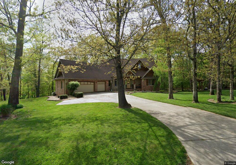
This home is located at 963 S Amber Ct, Nixa, MO 65714 and is currently estimated at $760,751, approximately $399 per square foot. 963 S Amber Ct is a home with nearby schools including Mathews Elementary School, Nicholas A. Inman Intermediate School, and Nixa Junior High School.
Ownership History
Date
Name
Owned For
Owner Type
Purchase Details
Closed on
Oct 6, 2020
Sold by
Stewart Daniel C and Stewart Linda M
Bought by
Stewart Daniel C and Stewart Linda M
Current Estimated Value
Home Financials for this Owner
Home Financials are based on the most recent Mortgage that was taken out on this home.
Original Mortgage
$186,600
Interest Rate
2.9%
Mortgage Type
New Conventional
Purchase Details
Closed on
May 20, 2015
Sold by
Stewart Daniel C and Stewart Linda M
Bought by
Stewart Daniel C and Stewart Linda M
Create a Home Valuation Report for This Property
The Home Valuation Report is an in-depth analysis detailing your home's value as well as a comparison with similar homes in the area
Purchase History
| Date | Buyer | Sale Price | Title Company |
|---|---|---|---|
| Stewart Daniel C | -- | Meridian Ttl Co All Branche | |
| Stewart Daniel C | -- | Meridian Ttl Co All Branches | |
| Stewart Daniel C | -- | None Available |
Source: Public Records
Mortgage History
| Date | Status | Borrower | Loan Amount |
|---|---|---|---|
| Closed | Stewart Daniel C | $186,600 |
Source: Public Records
Tax History
| Year | Tax Paid | Tax Assessment Tax Assessment Total Assessment is a certain percentage of the fair market value that is determined by local assessors to be the total taxable value of land and additions on the property. | Land | Improvement |
|---|---|---|---|---|
| 2025 | $3,868 | $69,500 | -- | -- |
| 2024 | $3,868 | $65,190 | -- | -- |
| 2023 | $3,868 | $65,190 | $0 | $0 |
| 2022 | $3,873 | $65,190 | $0 | $0 |
| 2021 | $3,875 | $65,190 | $0 | $0 |
| 2020 | $3,349 | $53,880 | $0 | $0 |
| 2019 | $3,349 | $53,880 | $0 | $0 |
| 2018 | $3,106 | $53,880 | $0 | $0 |
| 2017 | $3,106 | $53,880 | $0 | $0 |
| 2016 | $2,849 | $50,270 | $0 | $0 |
| 2015 | $2,853 | $50,270 | $50,270 | $0 |
| 2014 | $2,784 | $50,350 | $0 | $0 |
| 2013 | $2,789 | $50,350 | $0 | $0 |
| 2011 | -- | $104,080 | $0 | $0 |
Source: Public Records
Map
Nearby Homes
- 997 S Oak Ridge Rd
- 1642 W Inman Rd
- 145 S Blazing Star Ln
- 000 W Copper Creek Dr
- Tract 2 W Hicks Rd
- 176 Essex Rd
- 517 Stonehurst St
- 1319 Woodcastle Rd
- 2097 W Big Bend Rd
- 184 Apricot Ct
- 188 Highland Dr
- 1257 W Bridgewood Place
- 605 Glen Oaks Cir
- Lot 6 Mack Rd
- 422 Fieldstone Rd
- 1202 Glen Oaks Dr
- 1109 W Scenic Hills Dr
- 5 Ac Dewberry Rd
- Lot 3 Mack Rd
- 982 S Redwood St
- 985 S Amber Ct
- 974 Amber Ct
- 1900 W MacKenzies Way
- 1915 W MacKenzies
- 1850 W MacKenzies Way
- 997 Amber Ct
- 998 Amber Ct
- 1942 W MacKenzies Way
- 1893 W MacKenzies Way
- 1957 W MacKenzies Way
- 1955 W MacKenzies Way
- 1851 W Inman Rd
- 999 S Amber Ct
- 1945 Mackenzie Way
- 1941 W MacKenzies Way
- 1941 W MacKenzies Way
- 1949 Mackenzie Way
- 1732 W Inman Rd
- 1728 W Inman Rd
- 955 Marynell Ln
Your Personal Tour Guide
Ask me questions while you tour the home.