
Seller's Agent in 2025
Nancy King
Coldwell Banker Access Realty
(478) 747-8461
117 Total Sales
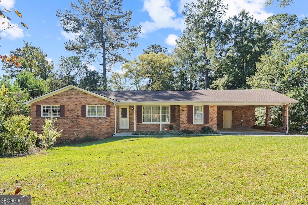
Charming Home with Flexible Living Space. This spacious home features 3 bedrooms and 2 full bathrooms on the main area, plus a private lower-level master suite with an en suite bath, cozy sitting area and kitchenette with washer/dryer hookup and a pantry, perfect for extended family, independent living or rental income. The lower level also includes a bonus room ideal for an office or hobby space with built ins for extra storage. Enjoy walk out access from the lower lever to the yard along with a screened porch and adjoining patio perfect for gatherings or quiet evenings outdoors. Whether used as an in-law quarters, private space for a young adult, guest accommodations, or even an AIRBNB for supplemental income, this home provides endless opportunities for multi-generational living or investment potential.
Last Agent to Sell the Property
Coldwell Banker Access Realty License #261409 Listed on: 10/21/2025
| Date | Type | Sale Price | Title Company |
|---|---|---|---|
| Special Warranty Deed | $255,000 | None Listed On Document | |
| Quit Claim Deed | -- | -- | |
| Executors Deed | $51,500 | None Available | |
| Executors Deed | $51,500 | None Available | |
| Deed | $94,500 | -- |
| Date | Status | Loan Amount | Loan Type |
|---|---|---|---|
| Open | $250,381 | FHA | |
| Previous Owner | $82,400 | New Conventional |
| Date | Event | Price | List to Sale | Price per Sq Ft |
|---|---|---|---|---|
| 12/02/2025 12/02/25 | Sold | $255,000 | 0.0% | $88 / Sq Ft |
| 10/30/2025 10/30/25 | Pending | -- | -- | -- |
| 10/21/2025 10/21/25 | For Sale | $255,000 | -- | $88 / Sq Ft |
| Year | Tax Paid | Tax Assessment Tax Assessment Total Assessment is a certain percentage of the fair market value that is determined by local assessors to be the total taxable value of land and additions on the property. | Land | Improvement |
|---|---|---|---|---|
| 2025 | $1,706 | $69,433 | $11,180 | $58,253 |
| 2024 | $1,650 | $64,952 | $11,180 | $53,772 |
| 2023 | $844 | $58,230 | $11,180 | $47,050 |
| 2022 | $1,955 | $63,458 | $8,272 | $55,186 |
| 2021 | $2,099 | $55,236 | $6,948 | $48,288 |
| 2020 | $1,550 | $53,784 | $6,948 | $46,836 |
| 2019 | $1,334 | $47,974 | $6,948 | $41,026 |
| 2018 | $1,966 | $43,683 | $6,287 | $37,396 |
| 2017 | $1,279 | $41,131 | $6,640 | $34,491 |
| 2016 | $1,118 | $39,316 | $6,640 | $32,676 |
| 2015 | $1,580 | $39,316 | $6,640 | $32,676 |
| 2014 | $1,995 | $41,869 | $7,378 | $34,491 |
Seller's Agent in 2025
Nancy King
Coldwell Banker Access Realty
(478) 747-8461
117 Total Sales
Buyer's Agent in 2025
Joseph Williams
Southern Classic Realtors
(478) 394-0565
85 Total Sales
Source: Georgia MLS
MLS Number: 10628814
APN: M044-0081
Disclaimer: Certain information contained herein is derived from information provided by parties other than Homes.com. All information provided is deemed reliable, but is not guaranteed to be accurate and should be independently verified.
![]() The data relating to real estate for sale on this web site comes in part from the Broker Reciprocity Program of Georgia MLS. Real estate listings held by brokerage firms other than Redfin are marked with the Broker Reciprocity logo and detailed information about them includes the name of the listing brokers. Information deemed reliable but not guaranteed. Copyright 2026 Georgia MLS. All rights reserved.
The data relating to real estate for sale on this web site comes in part from the Broker Reciprocity Program of Georgia MLS. Real estate listings held by brokerage firms other than Redfin are marked with the Broker Reciprocity logo and detailed information about them includes the name of the listing brokers. Information deemed reliable but not guaranteed. Copyright 2026 Georgia MLS. All rights reserved.
Ask me questions while you tour the home.