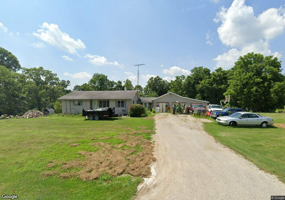
965 State Route 83 Beverly, OH 45715
Estimated Value: $161,000 - $208,000
3
Beds
2
Baths
1,084
Sq Ft
$166/Sq Ft
Est. Value
About This Home
This home is located at 965 State Route 83, Beverly, OH 45715 and is currently estimated at $180,385, approximately $166 per square foot. 965 State Route 83 is a home with nearby schools including Fort Frye High School.
Ownership History
Date
Name
Owned For
Owner Type
Purchase Details
Closed on
Jun 26, 2006
Sold by
Watts David E and Watts Bonnie
Bought by
Garvin Michael and Garvin Valarie
Current Estimated Value
Home Financials for this Owner
Home Financials are based on the most recent Mortgage that was taken out on this home.
Original Mortgage
$74,804
Outstanding Balance
$27,658
Interest Rate
6.72%
Mortgage Type
Commercial
Estimated Equity
$152,727
Purchase Details
Closed on
Jun 20, 2006
Sold by
David E David E and Watts Bonnie L
Bought by
Garvin Micharel and Garvin Valarie
Home Financials for this Owner
Home Financials are based on the most recent Mortgage that was taken out on this home.
Original Mortgage
$74,804
Outstanding Balance
$27,658
Interest Rate
6.72%
Mortgage Type
Commercial
Estimated Equity
$152,727
Create a Home Valuation Report for This Property
The Home Valuation Report is an in-depth analysis detailing your home's value as well as a comparison with similar homes in the area
Purchase History
We collect this data history from publicly available records. To have your information removed, we recommend requesting removal directly through your county’s website.
| Date | Buyer | Sale Price | Title Company |
|---|---|---|---|
| Garvin Michael | $98,500 | -- | |
| Garvin Micharel | -- | -- |
Source: Public Records
Mortgage History
We collect this data history from publicly available records. To have your information removed, we recommend requesting removal directly through your county’s website.
| Date | Status | Borrower | Loan Amount |
|---|---|---|---|
| Open | Garvin Michael | $74,804 | |
| Closed | Garvin Micharel | $74,804 |
Source: Public Records
Tax History
| Year | Tax Paid | Tax Assessment Tax Assessment Total Assessment is a certain percentage of the fair market value that is determined by local assessors to be the total taxable value of land and additions on the property. | Land | Improvement |
|---|---|---|---|---|
| 2025 | $1,185 | $39,010 | $7,980 | $31,030 |
| 2024 | $1,185 | $39,010 | $7,980 | $31,030 |
| 2023 | $1,185 | $28,430 | $6,800 | $21,630 |
| 2022 | $850 | $28,430 | $6,800 | $21,630 |
| 2021 | $854 | $28,430 | $6,800 | $21,630 |
| 2019 | $774 | $24,720 | $5,910 | $18,810 |
| 2018 | $731 | $24,720 | $5,910 | $18,810 |
| 2017 | $704 | $23,163 | $5,103 | $18,060 |
| 2016 | $702 | $23,163 | $5,103 | $18,060 |
| 2015 | $1,110 | $23,163 | $5,103 | $18,060 |
| 2014 | $745 | $23,163 | $5,103 | $18,060 |
| 2013 | $738 | $23,163 | $5,103 | $18,060 |
Source: Public Records
Map
Nearby Homes
- 911 Ohio 83
- 0 Creek Rd Unit 11695564
- 22 Spring St
- 0 Spring St Unit 5194005
- 0 Spring St Unit 5194017
- 0 Spring St Unit 5194023
- 0 Mary Ln Unit 5192391
- 1550 Swift Rd
- 717 Center St
- 500 Applegate Dr
- 0 Milner Rd
- 31 Leget St
- 2050 S State Route 266
- 0 Ohio 339
- 395 Main St
- 570 Coal Run Dr
- 0 Wilson Dr Unit 226018148
- 0 Hanson Rd Unit 5204758
- 0 Point Lookout Rd
- 0 Robert Wells Rd
- 911 State Route 83
- 877 State Route 83
- 845 State Route 83
- 8744 Mckown Ln
- 735 State Route 83
- 685 State Route 83
- 633 Ohio 83
- 8855 Mckown Ln
- 550 State Route 83
- 1405 State Route 83
- 8877 Mckown Ln
- 525 State Route 83
- 8888 Mckown Ln
- 8950 Mckown Ln
- 1495 State Route 83
- 8975 Mckown Ln
- 1500 State Route 83
- 8530 Wiley Ln
- 455 State Route 83
- 395 State Route 83
Your Personal Tour Guide
Ask me questions while you tour the home.