
Seller's Agent in 2026
Elizabeth Stricker
BF Realty
(513) 491-2561
1 in this area
8 Total Sales
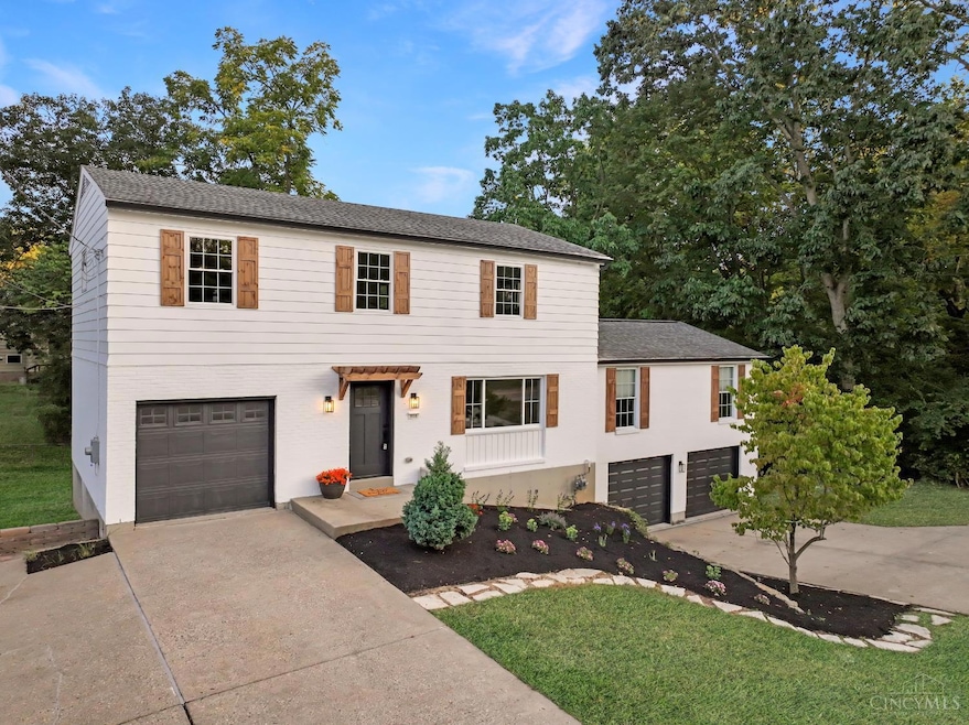


Beautifully renovated 4 bed, 2.5 bath home offering 2,147 sqft with a 3-car garage with full basement and dual extra-wide driveways for abundant parking. Updates include a stunning new kitchen with stainless steel appliances, spacious primary suite with walk-in closet featuring custom built-ins and makeup vanity, refinished hardwood floors, fresh interior/exterior paint, new windows, doors, and hardware. Designer lighting and plumbing fixtures throughout. Enjoy the large family room addition, perfect for gatherings, plus a private backyard with a huge party deck and professional landscaping. Agent related to seller. Move-in ready, priced to sell and can close quickly. Definite MUST SEE!!
Last Agent to Sell the Property
BF Realty License #2022006081 Listed on: 09/04/2025
| Date | Type | Sale Price | Title Company |
|---|---|---|---|
| Warranty Deed | $437,000 | Homestead Title | |
| Warranty Deed | $234,500 | Rapid Title | |
| Interfamily Deed Transfer | -- | None Available |
| Date | Status | Loan Amount | Loan Type |
|---|---|---|---|
| Open | $415,150 | New Conventional | |
| Previous Owner | $300,859 | Construction |
| Date | Event | Price | List to Sale | Price per Sq Ft |
|---|---|---|---|---|
| 02/06/2026 02/06/26 | Sold | $437,000 | -0.7% | $204 / Sq Ft |
| 12/07/2025 12/07/25 | Pending | -- | -- | -- |
| 11/20/2025 11/20/25 | Price Changed | $439,900 | -2.2% | $205 / Sq Ft |
| 10/31/2025 10/31/25 | For Sale | $449,900 | 0.0% | $210 / Sq Ft |
| 10/11/2025 10/11/25 | Pending | -- | -- | -- |
| 10/03/2025 10/03/25 | Price Changed | $449,900 | -9.1% | $210 / Sq Ft |
| 09/17/2025 09/17/25 | Price Changed | $495,000 | -1.0% | $231 / Sq Ft |
| 09/09/2025 09/09/25 | Price Changed | $499,900 | -4.8% | $233 / Sq Ft |
| 09/04/2025 09/04/25 | For Sale | $525,000 | -- | $245 / Sq Ft |
| Year | Tax Paid | Tax Assessment Tax Assessment Total Assessment is a certain percentage of the fair market value that is determined by local assessors to be the total taxable value of land and additions on the property. | Land | Improvement |
|---|---|---|---|---|
| 2025 | $5,514 | $98,431 | $8,887 | $89,544 |
| 2024 | $5,367 | $98,431 | $8,887 | $89,544 |
| 2023 | $5,150 | $98,431 | $8,887 | $89,544 |
| 2022 | $4,295 | $75,051 | $8,719 | $66,332 |
| 2021 | $4,183 | $75,051 | $8,719 | $66,332 |
| 2020 | $4,244 | $75,051 | $8,719 | $66,332 |
| 2019 | $4,063 | $66,416 | $7,714 | $58,702 |
| 2018 | $3,805 | $66,416 | $7,714 | $58,702 |
| 2017 | $3,582 | $66,416 | $7,714 | $58,702 |
| 2016 | $3,264 | $60,176 | $7,728 | $52,448 |
| 2015 | $3,176 | $60,176 | $7,728 | $52,448 |
| 2014 | $3,179 | $60,176 | $7,728 | $52,448 |
| 2013 | $2,937 | $58,997 | $7,578 | $51,419 |
Seller's Agent in 2026
Elizabeth Stricker
BF Realty
(513) 491-2561
1 in this area
8 Total Sales
Buyer's Agent in 2026
Brett Butler
Comey & Shepherd
(513) 218-1751
1 in this area
98 Total Sales
Source: MLS of Greater Cincinnati (CincyMLS)
MLS Number: 1854033
APN: 500-0471-0054
Disclaimer: Certain information contained herein is derived from information provided by parties other than Homes.com. All information provided is deemed reliable, but is not guaranteed to be accurate and should be independently verified.
![]() The data relating to real estate for sale on this website comes in part from the Broker Reciprocity programs of the MLS of Greater Cincinnati, Inc.. Those listings held by brokerage firms other than Ten-X are marked with the Broker Reciprocity logo and house icon. The properties displayed may not be all of the properties available through Broker Reciprocity.
The data relating to real estate for sale on this website comes in part from the Broker Reciprocity programs of the MLS of Greater Cincinnati, Inc.. Those listings held by brokerage firms other than Ten-X are marked with the Broker Reciprocity logo and house icon. The properties displayed may not be all of the properties available through Broker Reciprocity.
IDX information is provided exclusively for personal, non-commercial use, and may not be used for any purpose other than to identify prospective properties consumers may be interested in purchasing.
Information is deemed reliable but not guaranteed.
Ten-X does not display the entire Cincinnati MLS Broker Reciprocity™ database on this web site. The listings of some real estate brokerage firms have been excluded.
Copyright 2026, MLS of Greater Cincinnati, Inc. All rights reserved
Ask me questions while you tour the home.