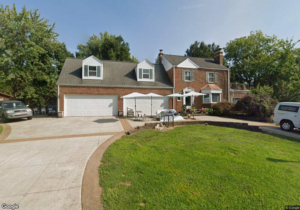
9726 Lenor Dr Saint Louis, MO 63123
Estimated Value: $319,000 - $380,445
3
Beds
1
Bath
2,915
Sq Ft
$121/Sq Ft
Est. Value
About This Home
This home is located at 9726 Lenor Dr, Saint Louis, MO 63123 and is currently estimated at $352,861, approximately $121 per square foot. 9726 Lenor Dr is a home located in St. Louis County with nearby schools including Mesnier Primary School, Gotsch Intermediate School, and Rogers Middle School.
Ownership History
Date
Name
Owned For
Owner Type
Purchase Details
Closed on
Jan 14, 2008
Sold by
Matlock Timothy Carl
Bought by
Matlock Timothy Carl
Current Estimated Value
Home Financials for this Owner
Home Financials are based on the most recent Mortgage that was taken out on this home.
Original Mortgage
$10,000
Outstanding Balance
$6,296
Interest Rate
6.11%
Mortgage Type
Credit Line Revolving
Estimated Equity
$346,565
Purchase Details
Closed on
Feb 15, 2007
Sold by
Matlock Timothy Carl and Matlock Maggie L
Bought by
Matlock Timothy Carl
Home Financials for this Owner
Home Financials are based on the most recent Mortgage that was taken out on this home.
Original Mortgage
$240,000
Interest Rate
6.17%
Mortgage Type
New Conventional
Purchase Details
Closed on
Sep 1, 2006
Sold by
Matlock Timothy Carl and Matlock Maggie L
Bought by
Matlock Timothy Carl and Matlock Maggie L
Home Financials for this Owner
Home Financials are based on the most recent Mortgage that was taken out on this home.
Original Mortgage
$240,000
Interest Rate
6.72%
Mortgage Type
New Conventional
Purchase Details
Closed on
Sep 5, 2003
Sold by
Lehmann Gilbert Amanda L
Bought by
Matlock Timothy Carl
Home Financials for this Owner
Home Financials are based on the most recent Mortgage that was taken out on this home.
Original Mortgage
$110,000
Interest Rate
5.87%
Mortgage Type
Purchase Money Mortgage
Purchase Details
Closed on
May 24, 2002
Sold by
Lehmann Gilbert Amanda L and Gilbert Dennis
Bought by
Lehmann Gilbert Amanda L
Home Financials for this Owner
Home Financials are based on the most recent Mortgage that was taken out on this home.
Original Mortgage
$120,000
Interest Rate
6.89%
Purchase Details
Closed on
Oct 19, 2001
Sold by
Kolath Joan M
Bought by
Gilbert Amanda
Home Financials for this Owner
Home Financials are based on the most recent Mortgage that was taken out on this home.
Original Mortgage
$86,367
Interest Rate
7.12%
Mortgage Type
FHA
Create a Home Valuation Report for This Property
The Home Valuation Report is an in-depth analysis detailing your home's value as well as a comparison with similar homes in the area
Home Values in the Area
Average Home Value in this Area
Purchase History
| Date | Buyer | Sale Price | Title Company |
|---|---|---|---|
| Matlock Timothy Carl | -- | Pulaski Title Company | |
| Matlock Timothy Carl | -- | Pulaski Title Company | |
| Matlock Timothy Carl | -- | Pulaski Title Company | |
| Matlock Timothy Carl | $137,500 | -- | |
| Lehmann Gilbert Amanda L | -- | -- | |
| Gilbert Amanda | $87,000 | First American Title Co |
Source: Public Records
Mortgage History
| Date | Status | Borrower | Loan Amount |
|---|---|---|---|
| Open | Matlock Timothy Carl | $10,000 | |
| Open | Matlock Timothy Carl | $262,500 | |
| Closed | Matlock Timothy Carl | $240,000 | |
| Closed | Matlock Timothy Carl | $240,000 | |
| Closed | Matlock Timothy Carl | $110,000 | |
| Previous Owner | Lehmann Gilbert Amanda L | $120,000 | |
| Previous Owner | Gilbert Amanda | $86,367 |
Source: Public Records
Tax History
| Year | Tax Paid | Tax Assessment Tax Assessment Total Assessment is a certain percentage of the fair market value that is determined by local assessors to be the total taxable value of land and additions on the property. | Land | Improvement |
|---|---|---|---|---|
| 2025 | $4,710 | $65,690 | $17,350 | $48,340 |
| 2024 | $4,710 | $55,690 | $12,540 | $43,150 |
| 2023 | $4,710 | $55,690 | $12,540 | $43,150 |
| 2022 | $4,034 | $42,470 | $13,490 | $28,980 |
| 2021 | $3,694 | $42,470 | $13,490 | $28,980 |
| 2020 | $4,032 | $43,310 | $9,600 | $33,710 |
| 2019 | $4,024 | $43,310 | $9,600 | $33,710 |
| 2018 | $4,085 | $38,840 | $9,600 | $29,240 |
| 2017 | $4,060 | $38,840 | $9,600 | $29,240 |
| 2016 | $3,381 | $34,240 | $10,550 | $23,690 |
| 2015 | $3,396 | $34,240 | $10,550 | $23,690 |
| 2014 | $3,967 | $39,920 | $5,450 | $34,470 |
Source: Public Records
Map
Nearby Homes
- 9840 Lakeford Ln
- 9835 Ridgely Ln
- 10358 Tiffany Village Circle Dr
- 9816 Lakeford Ln
- 9842 Coventry Ln
- 9838 Coventry Ln
- 10331 Jade Forest Dr
- 9831 Lindhall Ln
- 9723 Crayford Rd Unit 1D
- 9755 Newham Dr Unit 10D
- 9740 Bexley Station Dr Unit 7G
- 9740 Bexley Station Dr Unit 7J
- 8942 Eden Ave
- 10022 Killoren Dr
- 9504 Brenda Ave
- 9999 Casa Rosa Dr
- 10515 Copperfield Dr
- 9736 Wilderness Battle Cir
- 9337 Mackenzie Rd
- 10556 Crecelius Dr
- 10069 Lakeside Dr
- 9725 Lenor Dr
- 10061 Lakeside Dr
- 9718 Lenor Dr
- 9719 Lenor Dr
- 9733 Lenor Dr
- 10074 Lakeside Dr
- 9711 Lenor Dr
- 10053 Lakeside Dr
- 10050 Lakeside Dr
- 10050 Lenor Dr
- 9809 Lenor Dr
- 9816 Lenor Dr
- 10044 Lakeside Dr
- 10059 Lenor Dr
- 9815 Lenor Dr
- 10065 Lakeshire Dr
- 10041 Lakeside Dr
- 9824 Lenor Dr
- 10046 Lenor Dr
Your Personal Tour Guide
Ask me questions while you tour the home.