Estimated Value: $294,754 - $366,000
Studio
--
Bath
--
Sq Ft
457,380
Sq Ft Lot
About This Home
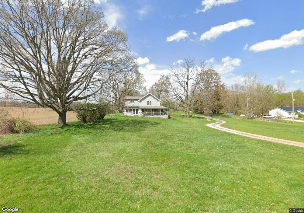
This home is located at 9763 Beard Rd, Byron, MI 48418 and is currently estimated at $321,189. 9763 Beard Rd is a home located in Shiawassee County with nearby schools including Byron Area Elementary School, Byron Area Middle School, and Byron Area High School.
Ownership History
Date
Name
Owned For
Owner Type
Purchase Details
Closed on
Dec 12, 2023
Sold by
Cool Carol A and Clissold Christine L
Bought by
Cool Carol A and Clissold Christine L
Current Estimated Value
Home Financials for this Owner
Home Financials are based on the most recent Mortgage that was taken out on this home.
Original Mortgage
$200,000
Outstanding Balance
$195,776
Interest Rate
7.44%
Mortgage Type
New Conventional
Estimated Equity
$125,413
Purchase Details
Closed on
May 12, 2015
Sold by
Cool Carol A
Bought by
Clissold Christine L M and Cool Carol A
Create a Home Valuation Report for This Property
The Home Valuation Report is an in-depth analysis detailing your home's value as well as a comparison with similar homes in the area
Purchase History
| Date | Buyer | Sale Price | Title Company |
|---|---|---|---|
| Cool Carol A | $250,000 | None Listed On Document | |
| Cool Carol A | $250,000 | None Listed On Document | |
| Clissold Christine L M | -- | None Available |
Source: Public Records
Mortgage History
| Date | Status | Borrower | Loan Amount |
|---|---|---|---|
| Open | Cool Carol A | $200,000 | |
| Closed | Cool Carol A | $200,000 |
Source: Public Records
Tax History
| Year | Tax Paid | Tax Assessment Tax Assessment Total Assessment is a certain percentage of the fair market value that is determined by local assessors to be the total taxable value of land and additions on the property. | Land | Improvement |
|---|---|---|---|---|
| 2025 | $6,327 | $154,100 | $0 | $0 |
| 2024 | $3,642 | $141,300 | $0 | $0 |
| 2023 | $926 | $135,100 | $0 | $0 |
| 2022 | $3,430 | $123,000 | $0 | $0 |
| 2021 | $3,254 | $115,000 | $0 | $0 |
| 2020 | $3,206 | $105,700 | $0 | $0 |
| 2019 | $3,152 | $88,000 | $0 | $0 |
| 2018 | $3,080 | $82,300 | $0 | $0 |
| 2017 | $2,960 | $74,200 | $0 | $0 |
| 2016 | -- | $74,200 | $0 | $0 |
| 2015 | -- | $70,300 | $0 | $0 |
| 2014 | -- | $66,600 | $0 | $0 |
Source: Public Records
Map
Nearby Homes
- 00 Lehring and Britton Roads
- Parcel E Turkey Trail
- Parcel F Turkey Trail
- Parcel D Turkey Trail
- 206 Emmett
- 215 Washington St
- 0 Lovejoy Rd Unit 20261017550
- vl Lehring Rd
- 14830 County Line Rd
- 12102 Rolston Rd
- Pine Knob Rd Lot Unit WP001
- VL W Bruff Rd
- 0 Williams Rd
- 8875 E Miller Rd
- 2555 E Cohoctah Rd
- 11036 Charles Dr
- 11035 Charles Dr
- 6632 Hanna Ct
- 6400 Sober Rd
- 4961 W Lovejoy Rd
- 9811 Beard Rd
- 9885 Beard Rd
- 9760 Beard Rd
- 9915 Beard Rd
- 12962 New Lothrop Rd
- 12974 New Lothrop Rd
- 9537 Beard Rd
- 12990 New Lothrop Rd
- 13026 New Lothrop Rd
- 12934 New Lothrop Rd
- 0000 E Beard Rd
- 10024 Beard Rd
- 13101 New Lothrop Rd
- 12722 New Lothrop Rd
- 10060 Beard Rd
- 13065 New Lothrop Rd
- 13065 New Lothrop Rd
- 13533 New Lothrop Rd
- 9404 Beard Rd
- 10100 Beard Rd
Your Personal Tour Guide
Ask me questions while you tour the home.