Estimated Value: $122,000 - $222,000
3
Beds
2
Baths
1,482
Sq Ft
$113/Sq Ft
Est. Value
About This Home
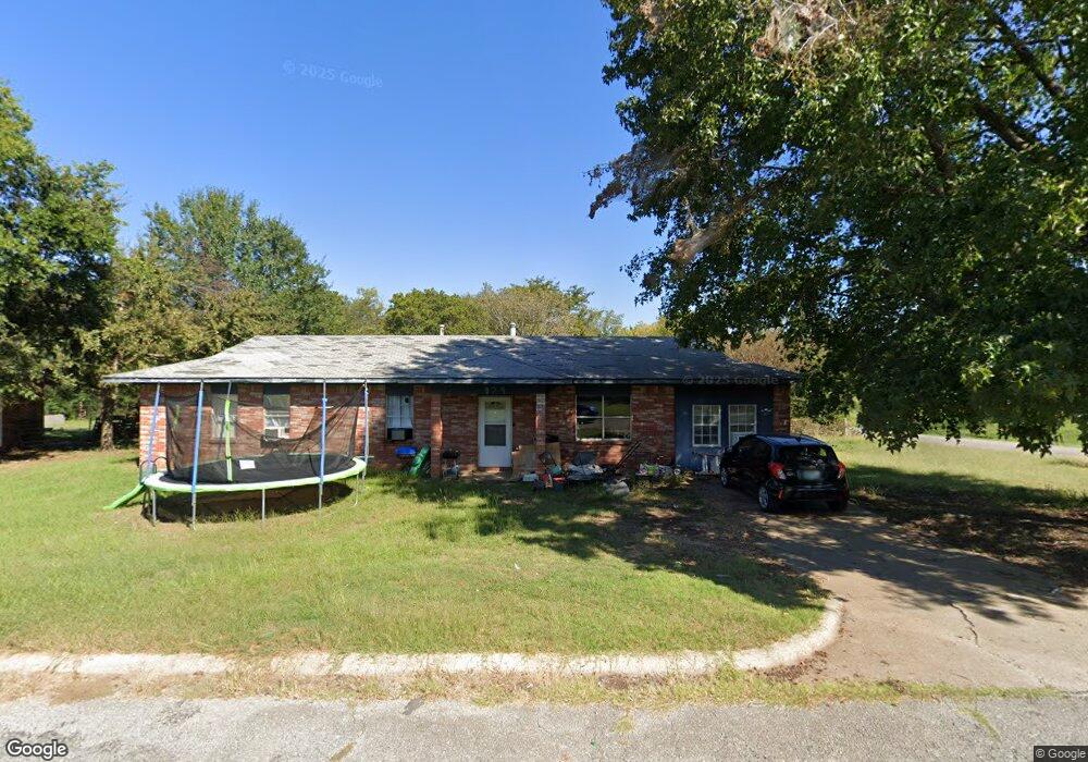
This home is located at 979 E Browne Ln, Atoka, OK 74525 and is currently estimated at $166,977, approximately $112 per square foot. 979 E Browne Ln is a home with nearby schools including Atoka Elementary School, Atoka High School, and Victory Life Academy of Atoka.
Ownership History
Date
Name
Owned For
Owner Type
Purchase Details
Closed on
Aug 18, 2017
Sold by
Workman Linda M S and Workman James R
Bought by
Kanin Jackson and Jackson Hallie
Current Estimated Value
Home Financials for this Owner
Home Financials are based on the most recent Mortgage that was taken out on this home.
Original Mortgage
$46,614
Outstanding Balance
$24,466
Interest Rate
4.03%
Mortgage Type
New Conventional
Estimated Equity
$142,511
Purchase Details
Closed on
May 28, 2013
Sold by
Heskett Henry
Bought by
Heskett Linda Mae Sander
Purchase Details
Closed on
Aug 9, 2010
Sold by
Raymond Cooper
Bought by
Heskett Henry Bryan
Purchase Details
Closed on
Apr 14, 2003
Sold by
Cha
Bought by
Cooper
Create a Home Valuation Report for This Property
The Home Valuation Report is an in-depth analysis detailing your home's value as well as a comparison with similar homes in the area
Home Values in the Area
Average Home Value in this Area
Purchase History
| Date | Buyer | Sale Price | Title Company |
|---|---|---|---|
| Kanin Jackson | $52,000 | -- | |
| Heskett Linda Mae Sander | -- | -- | |
| Heskett Henry Bryan | $10,000 | -- | |
| Cooper | -- | -- |
Source: Public Records
Mortgage History
| Date | Status | Borrower | Loan Amount |
|---|---|---|---|
| Open | Kanin Jackson | $46,614 |
Source: Public Records
Tax History
| Year | Tax Paid | Tax Assessment Tax Assessment Total Assessment is a certain percentage of the fair market value that is determined by local assessors to be the total taxable value of land and additions on the property. | Land | Improvement |
|---|---|---|---|---|
| 2025 | $349 | $3,619 | $247 | $3,372 |
| 2024 | $349 | $3,446 | $235 | $3,211 |
| 2023 | $309 | $3,282 | $232 | $3,050 |
| 2022 | $301 | $3,126 | $232 | $2,894 |
| 2021 | $292 | $2,977 | $232 | $2,745 |
| 2020 | $293 | $2,977 | $232 | $2,745 |
| 2019 | $305 | $3,079 | $232 | $2,847 |
| 2018 | $614 | $6,240 | $232 | $6,008 |
| 2017 | $158 | $1,597 | $232 | $1,365 |
| 2016 | $150 | $1,521 | $232 | $1,289 |
| 2015 | $142 | $1,449 | $232 | $1,217 |
| 2014 | $137 | $1,380 | $232 | $1,148 |
Source: Public Records
Map
Nearby Homes
- 0 E 10th St
- TBD Newman Ave
- 311 E A St
- 0 Hwy 69-75 St Unit 2532723
- 233 W 3rd St
- 565 S California Ave
- 824 S California Ave
- 215 N California Ave
- 167 N Montana Ave
- 346 W 8th St
- 0 S Gin Rd
- E E Highway 3
- 650 W 6th St
- 1260 S Oklahoma Ave
- 668 W 6th St
- 686 W 6th St
- 702 W 6th St
- 714 W 6th St
- 572 W 13th St
- 1672 S Velma Ave
- 902 E Browne Ln
- 945 E Browne Ln
- 964 E Browne Ln
- 910 Browne Ln
- 0 Browne Ln
- 791 S Dickerson Ave
- 745 S Dickerson Ave
- 834 S Dickerson Ave
- 714 E 6th St
- 774 S Mcclendon Ave
- 750 S Mcclendon Ave
- 728 S Mcclendon Ave
- 855 S Mcclendon Ave
- 886 S Dickerson Ave
- 796 S Mcclendon Ave
- 706 S Mcclendon Ave
- 13415 E Highway 3
- 873 S Mcclendon Ave
- 836 S Mcclendon Ave
- 700 E 6th St
Your Personal Tour Guide
Ask me questions while you tour the home.