
Seller's Agent in 2026
William Godwin
Godwin Realty Company
(219) 916-5507
1 in this area
60 Total Sales
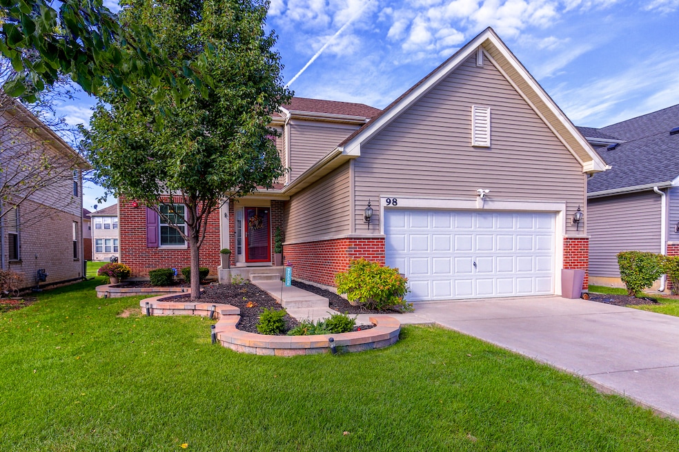
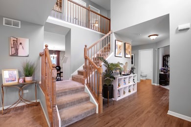
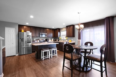
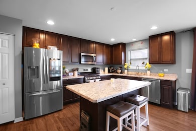
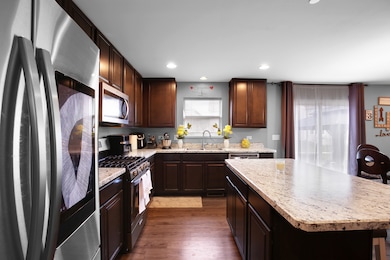


Welcome Home! a rarely available gem tucked in the highly sought-after Brookmere subdivision of Matteson, where suburban charm meets modern living. Brookmere is known for its tree-lined streets, quiet cul-de-sacs, and a true neighborhood vibe - just minutes from shopping, dining, parks, and easy access to major expressways for a quick downtown commute. Step inside and fall in love with this light-filled beauty. The moment you walk through the foyer, you're greeted by a warm living space or can retreat to the perfect home office, creative studio or bedroom. The open-concept kitchen and living room look out onto the peaceful backyard with an updated patio - ideal for weekend coffee mornings or summer gatherings. A convenient second-floor laundry steps from the bedrooms adds everyday ease. Upstairs, three spacious bedrooms await, including a primary suite that feels like your personal retreat. Downstairs, an unfinished basement offers instant equity potential - ready for your home gym, rec room, or entertainment space. Top it all off with an attached garage, well-kept landscaping, and a prime location in one of Matteson's most desirable neighborhoods. This home is move-in ready and has everything today's buyer is looking for.
Last Agent to Sell the Property
Godwin Realty Company License #471019862 Listed on: 10/20/2025
We collect this data history from publicly available records. To have your information removed, we recommend requesting removal directly through your county’s website.
We collect this data history from publicly available records. To have your information removed, we recommend requesting removal directly through your county’s website.
| Date | Type | Sale Price | Title Company |
|---|---|---|---|
| Warranty Deed | $350,000 | Chicago Title | |
| Special Warranty Deed | $235,000 | North American Title Co | |
| Special Warranty Deed | $2,800,000 | Cti |
We collect this data history from publicly available records. To have your information removed, we recommend requesting removal directly through your county’s website.
| Date | Status | Loan Amount | Loan Type |
|---|---|---|---|
| Open | $350,000 | VA | |
| Previous Owner | $227,527 | FHA |
We collect this data history from publicly available records. To have your information removed, we recommend requesting removal directly through your county’s website.
| Date | Event | Price | List to Sale | Price per Sq Ft |
|---|---|---|---|---|
| 05/18/2026 05/18/26 | Sold | $350,000 | 0.0% | $153 / Sq Ft |
| 04/14/2026 04/14/26 | Pending | -- | -- | -- |
| 04/10/2026 04/10/26 | Off Market | $350,000 | -- | -- |
| 04/06/2026 04/06/26 | Pending | -- | -- | -- |
| 03/02/2026 03/02/26 | Price Changed | $354,900 | -2.8% | $155 / Sq Ft |
| 12/03/2025 12/03/25 | Price Changed | $365,000 | -3.9% | $160 / Sq Ft |
| 10/20/2025 10/20/25 | For Sale | $379,900 | -- | $166 / Sq Ft |
We collect this data history from publicly available records. To have your information removed, we recommend requesting removal directly through your county’s website.
| Year | Tax Paid | Tax Assessment Tax Assessment Total Assessment is a certain percentage of the fair market value that is determined by local assessors to be the total taxable value of land and additions on the property. | Land | Improvement |
|---|---|---|---|---|
| 2025 | $12,719 | $34,000 | $5,675 | $28,325 |
| 2024 | $12,719 | $34,000 | $5,675 | $28,325 |
| 2023 | $10,500 | $34,000 | $5,675 | $28,325 |
| 2022 | $10,500 | $23,032 | $4,896 | $18,136 |
| 2021 | $10,647 | $23,032 | $4,896 | $18,136 |
| 2020 | $10,408 | $23,032 | $4,896 | $18,136 |
| 2019 | $11,703 | $24,849 | $1,669 | $23,180 |
| 2018 | $899 | $1,669 | $1,669 | $0 |
| 2017 | $874 | $1,669 | $1,669 | $0 |
| 2016 | $391 | $756 | $756 | $0 |
| 2015 | $384 | $756 | $756 | $0 |
| 2014 | $374 | $756 | $756 | $0 |
| 2013 | $272 | $591 | $591 | $0 |
Seller's Agent in 2026
William Godwin
Godwin Realty Company
(219) 916-5507
1 in this area
60 Total Sales
A
Buyer's Agent in 2026
Ashaunte Matthews
Real People Realty
(773) 993-5360
1 in this area
3 Total Sales
Source: Midwest Real Estate Data (MRED)
MLS Number: 12500724
APN: 31-16-207-016-0000
Disclaimer: Certain information contained herein is derived from information provided by parties other than Homes.com. All information provided is deemed reliable, but is not guaranteed to be accurate and should be independently verified.
![]() All data is obtained from various sources and may not have been verified by broker or MLS GRID. Supplied Open House Information is subject to change without notice. All information should be independently reviewed and verified for accuracy. Properties may or may not be listed by the office/agent presenting the information. Some IDX listings have been excluded from this website.
All data is obtained from various sources and may not have been verified by broker or MLS GRID. Supplied Open House Information is subject to change without notice. All information should be independently reviewed and verified for accuracy. Properties may or may not be listed by the office/agent presenting the information. Some IDX listings have been excluded from this website.
Listings courtesy of Midwest Real Estate Data (MRED) as distributed by MLS GRID.
Based on information submitted to the MLS GRID
Ask me questions while you tour the home.