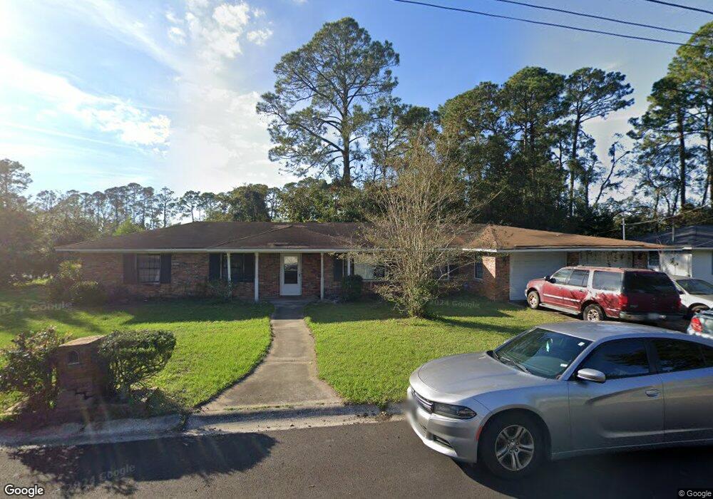
99 Camp Ln Brunswick, GA 31525
Estimated Value: $187,000 - $243,000
4
Beds
3
Baths
2,021
Sq Ft
$108/Sq Ft
Est. Value
About This Home
This home is located at 99 Camp Ln, Brunswick, GA 31525 and is currently estimated at $219,257, approximately $108 per square foot. 99 Camp Ln is a home located in Glynn County with nearby schools including Greer Elementary School, Needwood Middle School, and Brunswick High School.
Ownership History
Date
Name
Owned For
Owner Type
Purchase Details
Closed on
Aug 31, 2011
Sold by
Capital Mortgage Corporation
Bought by
Anderson W Harvey
Current Estimated Value
Purchase Details
Closed on
Sep 7, 2010
Sold by
Miller Ellis
Bought by
Capital Mortgage Corporation
Purchase Details
Closed on
Jan 29, 2010
Sold by
Capital Mortgage Corporation
Bought by
Miller Ellis
Home Financials for this Owner
Home Financials are based on the most recent Mortgage that was taken out on this home.
Original Mortgage
$91,225
Interest Rate
5.16%
Mortgage Type
New Conventional
Purchase Details
Closed on
Nov 3, 2009
Sold by
Shuman Irene K
Bought by
Capital Mortgage Corporation
Create a Home Valuation Report for This Property
The Home Valuation Report is an in-depth analysis detailing your home's value as well as a comparison with similar homes in the area
Home Values in the Area
Average Home Value in this Area
Purchase History
| Date | Buyer | Sale Price | Title Company |
|---|---|---|---|
| Anderson W Harvey | $44,081 | -- | |
| Capital Mortgage Corporation | $96,755 | -- | |
| Miller Ellis | $91,725 | -- | |
| Capital Mortgage Corporation | $100,659 | -- |
Source: Public Records
Mortgage History
| Date | Status | Borrower | Loan Amount |
|---|---|---|---|
| Previous Owner | Miller Ellis | $91,225 |
Source: Public Records
Tax History
| Year | Tax Paid | Tax Assessment Tax Assessment Total Assessment is a certain percentage of the fair market value that is determined by local assessors to be the total taxable value of land and additions on the property. | Land | Improvement |
|---|---|---|---|---|
| 2025 | $2,028 | $80,880 | $8,000 | $72,880 |
| 2024 | $1,848 | $73,680 | $5,080 | $68,600 |
| 2023 | $1,666 | $62,720 | $5,080 | $57,640 |
| 2022 | $1,483 | $54,160 | $5,080 | $49,080 |
| 2021 | $1,448 | $51,160 | $5,080 | $46,080 |
| 2020 | $1,461 | $51,160 | $5,080 | $46,080 |
| 2019 | $1,461 | $51,160 | $5,080 | $46,080 |
| 2018 | $1,199 | $41,120 | $3,400 | $37,720 |
| 2017 | $1,035 | $34,840 | $3,400 | $31,440 |
| 2016 | $860 | $30,640 | $3,400 | $27,240 |
| 2015 | $661 | $22,240 | $3,400 | $18,840 |
| 2014 | $661 | $22,240 | $3,400 | $18,840 |
Source: Public Records
Map
Nearby Homes
- 155 Mcdowell Ave
- 115 Shangri la Ave
- 135 Kensington Dr
- 100 Club Dr
- 6 Quail Run
- 137 Landover Cir
- 436 Lakespur Ln
- 1103 Fairway Rd
- 122 Chatford Dr
- 114 Landover Dr
- 342 Peppertree Crossing Ave
- 237 King Cotton Rd
- 71 E Chapel Dr
- 136 Peppertree Crossing Ave Unit 136
- 679 Shepard Dr
- 60 Powers Landing
- 555 Kell Rd
- 171 Drayton Cir
- 138 Crossbrook Dr
- 29 Lisa Ln
Your Personal Tour Guide
Ask me questions while you tour the home.