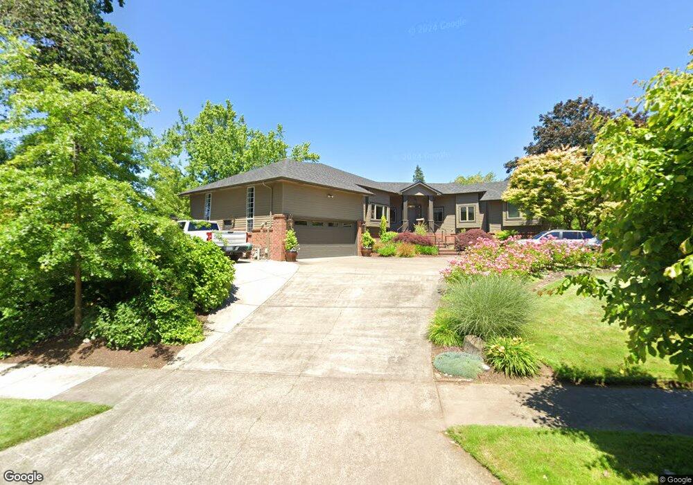
990 St Andrews Dr Eugene, OR 97401
Cal Young NeighborhoodEstimated Value: $980,000 - $1,166,000
3
Beds
3
Baths
3,463
Sq Ft
$313/Sq Ft
Est. Value
About This Home
This home is located at 990 St Andrews Dr, Eugene, OR 97401 and is currently estimated at $1,083,915, approximately $312 per square foot. 990 St Andrews Dr is a home located in Lane County with nearby schools including Willagillespie Elementary School, Monroe Middle School, and Sheldon High School.
Ownership History
Date
Name
Owned For
Owner Type
Purchase Details
Closed on
Mar 1, 2010
Sold by
Frichette Steven A and Frichette Achelle M
Bought by
Frichette Steven A and Frichette Achelle Mohr
Current Estimated Value
Home Financials for this Owner
Home Financials are based on the most recent Mortgage that was taken out on this home.
Original Mortgage
$385,000
Outstanding Balance
$253,031
Interest Rate
4.97%
Mortgage Type
New Conventional
Estimated Equity
$830,884
Purchase Details
Closed on
Jan 13, 2006
Sold by
Lubis Rossini
Bought by
Frichette Steven A and Frichette Achelle M
Home Financials for this Owner
Home Financials are based on the most recent Mortgage that was taken out on this home.
Original Mortgage
$305,120
Interest Rate
6.21%
Mortgage Type
Fannie Mae Freddie Mac
Create a Home Valuation Report for This Property
The Home Valuation Report is an in-depth analysis detailing your home's value as well as a comparison with similar homes in the area
Home Values in the Area
Average Home Value in this Area
Purchase History
| Date | Buyer | Sale Price | Title Company |
|---|---|---|---|
| Frichette Steven A | -- | Western Title & Escrow | |
| Frichette Steven A | $381,400 | Western Title & Escrow Compa |
Source: Public Records
Mortgage History
| Date | Status | Borrower | Loan Amount |
|---|---|---|---|
| Open | Frichette Steven A | $385,000 | |
| Closed | Frichette Steven A | $305,120 |
Source: Public Records
Tax History
| Year | Tax Paid | Tax Assessment Tax Assessment Total Assessment is a certain percentage of the fair market value that is determined by local assessors to be the total taxable value of land and additions on the property. | Land | Improvement |
|---|---|---|---|---|
| 2025 | $12,123 | $622,228 | -- | -- |
| 2024 | $11,973 | $604,105 | -- | -- |
| 2023 | $11,973 | $586,510 | $0 | $0 |
| 2022 | $11,216 | $569,428 | $0 | $0 |
| 2021 | $10,535 | $552,843 | $0 | $0 |
| 2020 | $10,572 | $536,741 | $0 | $0 |
| 2019 | $10,210 | $521,108 | $0 | $0 |
| 2018 | $9,611 | $491,195 | $0 | $0 |
| 2017 | $9,180 | $491,195 | $0 | $0 |
| 2016 | $8,953 | $476,888 | $0 | $0 |
| 2015 | $8,591 | $462,998 | $0 | $0 |
| 2014 | $8,369 | $449,513 | $0 | $0 |
Source: Public Records
Map
Nearby Homes
- 820 Lariat Dr
- 2250 Turnberry Ct
- 2150 Greenview St
- 1090 Corydon St
- 1521 Gilham Rd
- 0 Cal Young Rd Unit Lot 4
- 982 Shaughnessy Ln
- 950 Coburg Rd
- 1943 Monterey Ln
- 2345 Pioneer Pike
- 516 Spyglass Dr
- 600 Cherry Dr Unit 8
- 600 Cherry Dr Unit 3
- 410 Spyglass Dr
- 347 Rustic Place Unit 14
- 1328 Spyglass Dr
- 2015 Eastwood Ln
- 1625 Monterey Ln
- 2746 Harlow Rd
- 367 Rustic Place
Your Personal Tour Guide
Ask me questions while you tour the home.