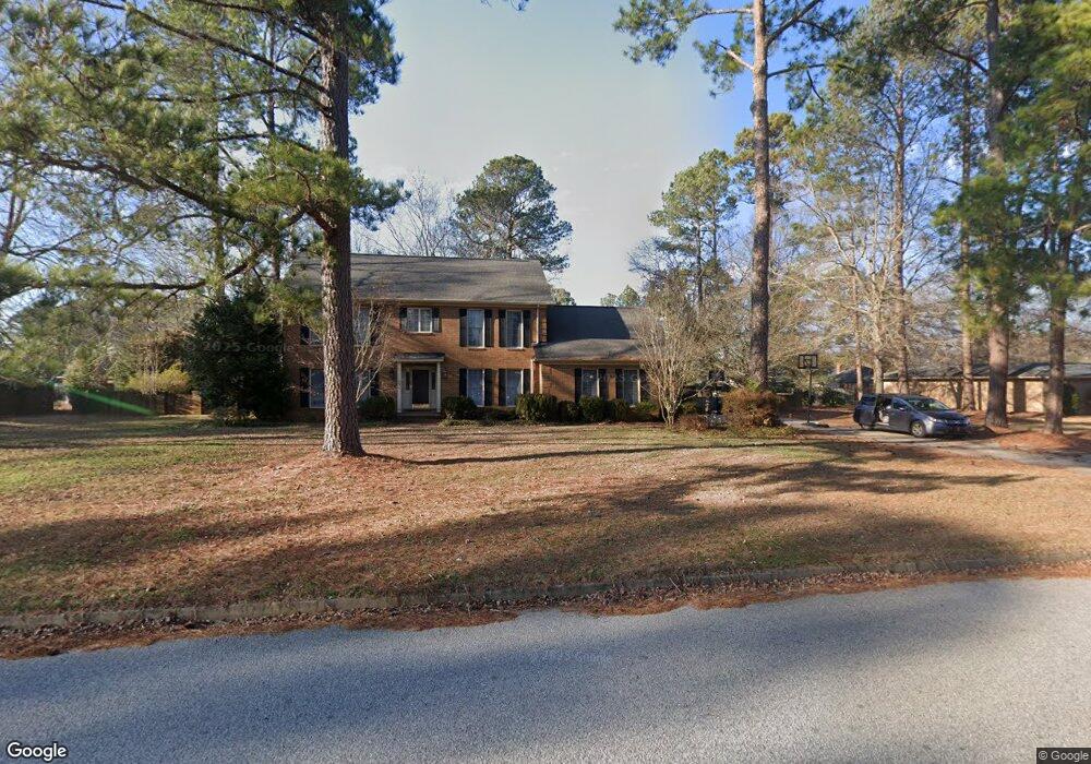
993 Antlers Dr Sumter, SC 29150
Estimated Value: $339,783 - $361,000
4
Beds
3
Baths
2,460
Sq Ft
$141/Sq Ft
Est. Value
About This Home
This home is located at 993 Antlers Dr, Sumter, SC 29150 and is currently estimated at $347,446, approximately $141 per square foot. 993 Antlers Dr is a home located in Sumter County with nearby schools including Alice Drive Elementary School, Alice Drive Middle School, and Sumter High School.
Ownership History
Date
Name
Owned For
Owner Type
Purchase Details
Closed on
Feb 29, 2024
Sold by
Forester Mark S and Forester Lori W
Bought by
Forester Taylor S and Forester Ashley N
Current Estimated Value
Home Financials for this Owner
Home Financials are based on the most recent Mortgage that was taken out on this home.
Original Mortgage
$310,000
Outstanding Balance
$303,900
Interest Rate
6.6%
Mortgage Type
VA
Estimated Equity
$43,546
Purchase Details
Closed on
Jun 12, 2007
Sold by
Fox Beverly
Bought by
Forester Mark S and Forester Lori W
Home Financials for this Owner
Home Financials are based on the most recent Mortgage that was taken out on this home.
Original Mortgage
$246,900
Interest Rate
6.37%
Mortgage Type
VA
Create a Home Valuation Report for This Property
The Home Valuation Report is an in-depth analysis detailing your home's value as well as a comparison with similar homes in the area
Purchase History
We collect this data history from publicly available records. To have your information removed, we recommend requesting removal directly through your county’s website.
| Date | Buyer | Sale Price | Title Company |
|---|---|---|---|
| Forester Taylor S | $310,000 | None Listed On Document | |
| Forester Mark S | $246,900 | None Available |
Source: Public Records
Mortgage History
We collect this data history from publicly available records. To have your information removed, we recommend requesting removal directly through your county’s website.
| Date | Status | Borrower | Loan Amount |
|---|---|---|---|
| Open | Forester Taylor S | $310,000 | |
| Previous Owner | Forester Mark S | $246,900 |
Source: Public Records
Tax History
| Year | Tax Paid | Tax Assessment Tax Assessment Total Assessment is a certain percentage of the fair market value that is determined by local assessors to be the total taxable value of land and additions on the property. | Land | Improvement |
|---|---|---|---|---|
| 2025 | $2,108 | -- | -- | -- |
| 2024 | $2,108 | -- | -- | -- |
| 2023 | $2,108 | $11,540 | $2,340 | $9,200 |
| 2022 | $2,099 | $11,540 | $2,340 | $9,200 |
| 2021 | $1,934 | $11,540 | $2,340 | $9,200 |
| 2020 | $1,934 | $9,960 | $2,340 | $7,620 |
| 2019 | $1,918 | $9,960 | $2,340 | $7,620 |
| 2018 | $1,848 | $9,960 | $2,340 | $7,620 |
| 2017 | $1,887 | $9,960 | $2,340 | $7,620 |
| 2016 | $1,917 | $9,960 | $2,340 | $7,620 |
| 2015 | $2,014 | $10,100 | $2,340 | $7,760 |
| 2014 | $2,014 | $10,100 | $2,340 | $7,760 |
| 2013 | -- | $10,100 | $2,340 | $7,760 |
Source: Public Records
Map
Nearby Homes
- 59 Pathfinder Dr
- 50 Oystercatcher Ct
- 70 Oystercatcher Ct
- 719 Fawn Cir
- 1325 Curlew Cir
- 30 Baldpate Cove
- 20 Oystercatcher Ct
- 1305 Curlew Cir
- 1235 Curlew Cir
- 1295 Curlew Cir
- 1265 Curlew Cir
- 1275 Curlew Cir
- 1245 Curlew Cir
- 1285 Curlew Cir
- 670 E Glouchester Dr
- 2525 Merganzer Dr
- 1030 Curlew Cir
- 1050 Curlew Cir
- 520 Mallard Dr
- 2820 Widgeon Way
- 997 Antlers Dr
- 991 Antlers Dr
- 910 S Wise Dr
- 914 S Wise Dr
- 1 Pathfinder Dr
- 490 Arrowhead Dr
- 918 S Wise Dr
- 1001 Antlers Dr
- 902 Antlers Dr
- 2 Pathfinder Dr
- 922 S Wise Dr
- 5 Pathfinder Dr
- 1003 Antlers Dr
- 822 Antlers Dr
- 500 Huron Dr
- 1004 Antlers Dr
- 823 Antlers Dr
- 926 S Wise Dr
- 9 Pathfinder Dr
- 834 S Wise Dr
Your Personal Tour Guide
Ask me questions while you tour the home.