$80,000
SOLD JUN 10, 2026

TBD Aes Rd Spiro, OK 74959

19 Acres
$4,211 Price per Acre
827,640 Sq Ft Lot

Sale Details

Date Sold: June 10, 2026

4 Days on Market

Highlights

  • 19 Acre Lot
  • Creek or Stream
  • Partially Fenced Property
  • Wooded Lot

About This Lot

As of June 2026

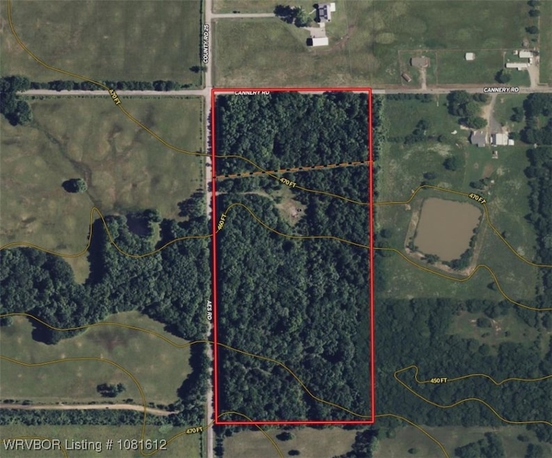
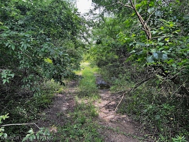
A 19m/l acre tract located just 1 mile south of US Hwy 271 at the southeast corner of AES/Cannery Road in Spiro. This wooded property features a wet-weather creek, creating a natural habitat for wildlife and offering a peaceful, secluded setting. The land offers excellent potential—clear a homesite and build your dream home, enjoy the land for recreation, or add to your investment portfolio. Located approximately 20 minutes from both Fort Smith, AR and Poteau, OK, with easy highway access and rural charm. A gas well is located on the property. Mineral rights do not convey with the sale.

Last Agent to Sell the Property

Melissa Craig

All About U Real Estate License #PB00086508 Listed on: 06/08/2025

Last Buyer's Agent

Melissa Craig

All About U Real Estate License #PB00086508 Listed on: 06/08/2025

Property Details

Property Type

  • Land

Lot Details

  • 19 Acre Lot
  • Lot Dimensions are 625x1322
  • Property fronts a county road
  • Creek or Stream
  • Rural Setting
  • Partially Fenced Property
  • Wire Fence
  • Sloped Lot
  • Wooded Lot

Home Design

  • Mixed Use

Location

  • Flood Zone Lot
  • Outside City Limits

Schools

  • Spiro Elementary School
  • Sprio Middle School
  • Spiro High School

Mobile Home

  • Mobile Home Allowed

Utilities

  • Not Connected to Water Source
  • Septic Needed

Listing and Financial Details

  • Assessor Parcel Number 0000-27-09N-25E-0-004-00

Property Details

Property Type

Land

Lot Details

19 Acres

Listing Details

  • Reso Property Sub Type: Mixed Use
  • Prop. Type: Land
  • ResoLotFeatures: Mobile Home Allowed, Outside City Limits, Rural Lot, Flood Zone, Stream/Creek, Wooded
  • Road Frontage Type: County Road
  • Road Surface Type: Paved
  • Co List Office Mls Id: O22072
  • ResoSpecialListingConditions: None
  • Subdivision Name: na
  • Directions: West of Spiro on US Hwy 271, turn south onto AES Rd. Go 1 mile property is on the southeast corner of AES/Cannery Rd.
  • Property Sub Type Additional: Mixed Use
  • Special Features: VirtualTour
  • Property Sub Type: LotsLands

Exterior Features

  • Fencing: Partial, Wire
  • Acres: 19.0
  • Topography: Sloping

Utilities

  • Utilities: Electricity Available
  • Water Source: Not Connected (nearby), Public

Condo/Co-op/Association

  • Community Features: Other, See Remarks

Schools

  • Ninth Grade High School: Spiro
  • Middle Or Junior School: Sprio

Lot Info

  • Lot Dimensions: 625x1322
  • ResoLotSizeUnits: Acres
  • Parcel #: 0000-27-09N-25E-0-004-00

Tax Info

  • Tax Annual Amount: 83.0
  • Tax Block: na
  • Tax Lot: na

MLS Schools

  • Elementary School: Spiro
Create a Home Valuation Report for This Property
The Home Valuation Report is an in-depth analysis detailing your home's value as well as a comparison with similar homes in the area

Property History

We collect this data history from publicly available records. To have your information removed, we recommend requesting removal directly through your county’s website.

Date Event Price List to Sale Price per Sq Ft Prior Sale
06/10/2026 06/10/26 Sold $80,000 +17.6% --
02/11/2026 02/11/26 Sold $68,000 0.0% -- View Prior Sale
11/25/2025 11/25/25 Pending -- -- --
11/14/2025 11/14/25 For Sale $68,000 -15.0% --
06/12/2025 06/12/25 Pending -- -- --
06/08/2025 06/08/25 For Sale $80,000 -- --
Source: Western River Valley Board of REALTORS®

Agents Affiliated with this Home

  • Section Image
  • Section Image
  • Section Image
See All Agents

Map

Source: Western River Valley Board of REALTORS®

MLS Number: 1081612

Your Personal Tour Guide

Ask me questions while you tour the home.