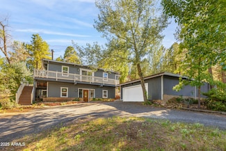
Why Live in Smokerise Valley
Smokerise Valley in Flagstaff features 1970s and early ‘80s ranch-style homes with winged roofs, shaded front doors, and two-car garages. These three-to-four-bedroom houses, ranging from 1,300 to 2,000 square feet, are set along narrow, sidewalk-lined streets with stone-edged flower beds and mature elm and pine trees. The neighborhood is bordered by Highway 89 and is about 6 miles from Downtown Flagstaff, with Interstate 40 and Historic Route 66 roughly 2 miles southwest. Despite its proximity to major roads, traffic noise is minimal due to lower speed limits and the residential streets' distance from the highway. Residents can commute via car, Mountain Line Public Transit, or Amtrak from the downtown station. Smokerise Park, located near Mount Elden, offers a half-basketball court, playground, and walking path. Outdoor enthusiasts can access the Coconino National Forest's Fatman’s Loop Trail directly from the neighborhood. Picture Canyon Natural and Cultural Preserve, about 3 miles southeast, features trails like the Tom Moody Loop. Local amenities include shops, restaurants, and a Safeway grocery store within a mile, with the Flagstaff Mall and big-box retailers a short bike ride away. Halloween is a significant event, attracting families from nearby areas.
Home Trends in Smokerise Valley, AZ
On average, homes in Smokerise Valley, Flagstaff sell after 31 days on the market compared to the national average of 52 days. The median sale price for homes in Smokerise Valley, Flagstaff over the last 12 months is $515,000, up 3% from the median home sale price over the previous 12 months.
Median Sale Price
$515,000
Median Single Family Sale Price
$524,950
Average Price Per Sq Ft
$982
Number of Homes for Sale
3
Last 12 months Home Sales
14
Median List Price
$532,450
Median Change From 1st List Price
0%
Median Home Sale Price YoY Change
3%