


0 600 N Unit 105629 Hurricane, UT 84737
Estimated payment $5,320/month
Highlights
- No HOA
- Brush Vegetation
- Level Lot
About This Lot
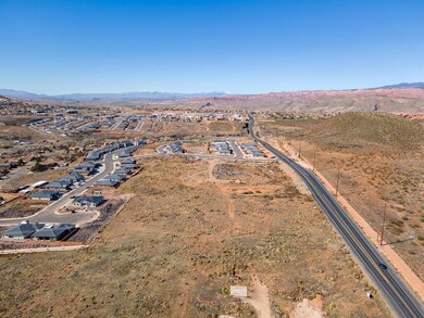
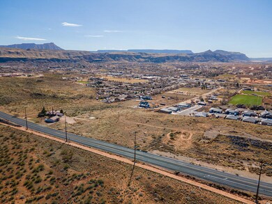
Incredible development opportunity for a mixed-use development on up to 13 acres in a prime location on Hurricane's 600 north commercial corridor. This 2.48 acre lot, zoned Neighborhood commercial, offers direct access from 600 North with approved improvements via 1380 West which is a master planned road and is conveniently situated across from a tortoise reserve, providing a tranquil and picturesque backdrop. Additionally, the proximity to two other available and adjacent parcels opens up the potential for a mixed-use development spanning nearly 13 acres. This property is key to this potential opportunity and has the potential to become a thriving commercial and residential hub in the community. Don't miss out on this rare chance to create a dynamic and sustainable development in a highly desirable area. Utilities will come from 1380 West at the 1400 West juncture. Power lines run along the eastern border of the parcel. There is also a potential for a secondary access through the parcel to the west off 1450 West. Major turn lanes have already been improved off 600 North in this area. Please call for all information related to this parcel.
Listing Agent
ERA BROKERS CONSOLIDATED (HURRICANE) License #5487745-AB00 Listed on: 02/20/2024
Property Details
Property Type
- Land
Est. Annual Taxes
- $786
Lot Details
- 2.48 Acre Lot
- Brush Vegetation
- Native Plants
- Level Lot
- Property is zoned NC
Community Details
- No Home Owners Association
Listing and Financial Details
- Assessor Parcel Number H-3-1-33-1443
Map
Home Values in the Area
Average Home Value in this Area
Property History
| Date | Event | Price | List to Sale | Price per Sq Ft |
|---|---|---|---|---|
| 02/20/2024 02/20/24 | For Sale | $999,000 | -- | -- |
Source: Iron County Board of REALTORS®
MLS Number: 105629
- 0 600 N Unit 24-248447
- 1575 W 540 N
- 1601 W 470 N Unit 60
- 1601 W 470 N
- 1589 W 470 N Unit 59
- 1502 W 460 N
- 1567 W 540 N
- 369 N Firerock Way
- 369 N Firerock Way Unit 101
- 357 N Firerock Way Unit 100
- 357 N Firerock Way
- 362 Firerock Way
- Slickrock (Slab) Plan at Fire Rock
- Sydney (Walkout) Plan at Fire Rock
- Providence (Slab) Plan at Fire Rock
- Sydney (Slab) Plan at Fire Rock
- Oasis (Slab) Plan at Fire Rock
- Oakley (Walkout) Plan at Fire Rock
- Oakley (Slab) Plan at Fire Rock
- Harmony (Walkout) Plan at Fire Rock
- 485 N 2170 W
- 508 N 2480 W
- 286 S 1930 W
- 296 S 1930 W
- 310 S 1930 W
- 489 N 530 W
- 110 Blackrock Rd
- 311 E 920 N
- 1545 S Ash Creek Dr
- 3364 W 2490 S Unit ID1250633P
- 3273 W 2530 S Unit ID1250638P
- 3020 Silver Reef Dr
- 1 Rainbow Ln
- 3212 S 4900 W
- 128 N Lone Rock Dr Unit A-303
- 128 N Lone Rock Dr Unit A105
- 3252 S 4900 W
- 1358 S Pole Creek Ln
- 190 N Red Stone Rd
- 325 N Red Stone Rd Unit 201
