
0 82 Rd E Unit 1035759 Livermore, CO 80536
Estimated payment $1,679/month
Highlights
- Horses Allowed On Property
- Mountain View
- Wooded Lot
- 42.15 Acre Lot
- Near a National Forest
- No HOA
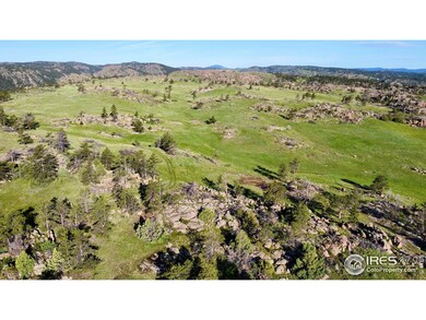
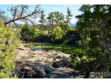
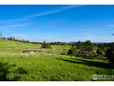
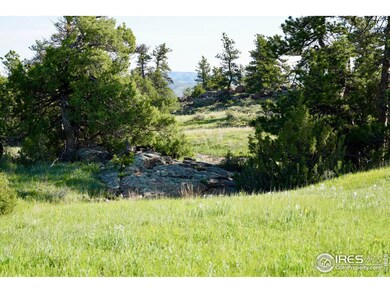
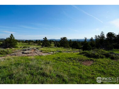
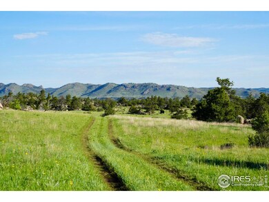
About This Lot
A beautiful 42 acre parcel that sits atop a ridge with views to the North, South and Southeast. There is a domestic well and the property is nearly all fenced. The opportunities are endless with this blank canvas awaiting the right buyer to make it their own. The property is mostly level with rolling grassland, rock outcroppings, trees and wide open meadows. The property borders State BLM land that abuts US Forest Service land in unit 191. A domestic well accompanies two natural springs on the property. With State BLM land bordering the property, the recreational opportunities are endless. A short hike and you will find the Middle Fork of Rabbit Creek.
Property Details
Property Type
- Land
Lot Details
- 42.15 Acre Lot
- Property fronts a private road
- Property fronts an easement
- Dirt Road
- Partially Fenced Property
- Wire Fence
- Rock Outcropping
- Level Lot
- Wooded Lot
- Landscaped with Trees
- Property is zoned Ag Grazing
Schools
- Livermore Elementary School
- Poudre High School
Additional Features
- Mountain Views
- Horses Allowed On Property
- Irrigation Well
Community Details
- No Home Owners Association
- Near a National Forest
Listing and Financial Details
- Assessor Parcel Number R1207245
Map
Home Values in the Area
Average Home Value in this Area
Tax History
| Year | Tax Paid | Tax Assessment Tax Assessment Total Assessment is a certain percentage of the fair market value that is determined by local assessors to be the total taxable value of land and additions on the property. | Land | Improvement |
|---|---|---|---|---|
| 2025 | $23 | $238 | $238 | -- |
| 2024 | $22 | $238 | $238 | -- |
| 2022 | $22 | $232 | $232 | $0 |
| 2021 | $23 | $255 | $255 | $0 |
| 2020 | $22 | $247 | $247 | $0 |
| 2019 | $22 | $247 | $247 | $0 |
| 2018 | $20 | $235 | $235 | $0 |
| 2017 | $20 | $235 | $235 | $0 |
| 2016 | $19 | $218 | $218 | $0 |
| 2015 | $19 | $220 | $220 | $0 |
| 2014 | $17 | $200 | $200 | $0 |
Property History
| Date | Event | Price | List to Sale | Price per Sq Ft |
|---|---|---|---|---|
| 11/19/2025 11/19/25 | Pending | -- | -- | -- |
| 08/03/2025 08/03/25 | For Sale | $319,000 | 0.0% | -- |
| 06/23/2025 06/23/25 | Pending | -- | -- | -- |
| 06/03/2025 06/03/25 | For Sale | $319,000 | -- | -- |
Purchase History
| Date | Type | Sale Price | Title Company |
|---|---|---|---|
| Warranty Deed | $143,000 | Land Title Guarantee Company | |
| Quit Claim Deed | $25,637 | -- | |
| Warranty Deed | $48,000 | -- | |
| Quit Claim Deed | -- | -- |
Mortgage History
| Date | Status | Loan Amount | Loan Type |
|---|---|---|---|
| Open | $121,500 | Purchase Money Mortgage |
Source: IRES MLS
MLS Number: 1035759
APN: 10170-00-026
Disclaimer: Certain information contained herein is derived from information provided by parties other than Homes.com. All information provided is deemed reliable, but is not guaranteed to be accurate and should be independently verified.
![]() Information source: Information and Real Estate Services, LLC. Provided for limited non-commercial use only under IRES Rules © Copyright IRES.
Information source: Information and Real Estate Services, LLC. Provided for limited non-commercial use only under IRES Rules © Copyright IRES.
Listing information is provided exclusively for consumers' personal, non-commercial use and may not be used for any purpose other than to identify prospective properties consumers may be interested in purchasing.
Information deemed reliable but not guaranteed by the MLS.
- 0 Tbd County Road 82 E
- 815 W County Road 82e
- 846 Boxer Ranch Rd
- 950 Meadow Creek Rd
- 816 Meadow Creek Rd
- 15 Sloan Rd
- 3676 Cherokee Meadows Rd
- 0 Legacy Rock Rd
- 490 Gordon Ct
- 569 Gordon Ct
- 13101 N County Road 73c Rd
- 0 Hwy 287 Unit 11116855
- 23930 N Highway 287
- 120 Joy Rd
- 241 Deadhorse Mountain Ct
- 556 Bald Mountain Dr
- 1084 Iron Mountain Dr
- 98 Deadhorse Mountain Ct
- 202 Roundtree Rd
- 238 Springmeadow Way
