$240,000
SOLD JAN 13, 2025

0 Chesapeak Rd Unit 22938 Alma, GA 31510

68 Acres
$3,513 Price per Acre
2,975,584 Sq Ft Lot

Recently Sold

9 Days on Market

About This Lot

As of January 2025

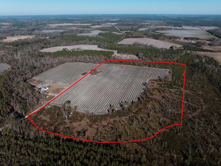
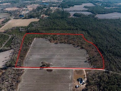
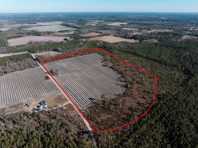
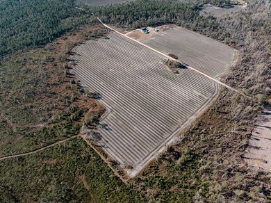
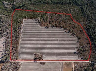
For sale: a fantastic 68+/-acre property that's perfect for you! Located in Alma, GA, this land offers plenty of space to build your dream home, making it an ideal home site. If you enjoy hunting, you'll love the abundant wildlife, with great opportunities for deer and turkey hunting. The fertile land is also perfect for farming, whether you want to grow crops or raise animals. With beautiful views and quiet spots to relax, you can enjoy the serenity of nature while still being close to Alma GA for convenience. Don't miss out on this amazing opportunity—call today to check it out!

Last Agent to Sell the Property

Joshua Landmon

Elevation Property Group LLC License #394786 Listed on: 12/11/2024

Last Buyer's Agent

Joshua Landmon

Elevation Property Group LLC License #394786 Listed on: 12/11/2024

Property Details

Property Type

  • Land

Est. Annual Taxes

  • $1,886

Lot Details

  • 68.31 Acre Lot
  • Dirt Road

Utilities

  • Water Not Available
  • Sewer Not Available

Listing and Financial Details

  • Assessor Parcel Number 011 415010

Property Details

Property Type

Land

Est. Annual Taxes

$1,886

Lot Details

0

Listing Details

  • Property Sub Type: Unimproved Land
  • Prop. Type: Land
  • Lot Size Acres: 68.31
  • Road Surface Type: Dirt
  • Subdivision Name: --
  • Directions: From Forks Gas Station at 2356 U.S. Hwy 1 N, Alma, GA, head north on U.S. Hwy 1 to US-23 S (25 seconds, 259 feet). Then, drive for about 12 minutes along Pine Level Church Rd, W 4th St Extension, and Hand Bookkeeping Rd (8.5 miles). Finally, take Biscayne Rd to Chesapeake Rd (3 minutes, 0.7 miles). Your destination is at 0 Chesapeake Rd, Alma, GA.
  • Special Features: None

Exterior Features

  • Lot Features: 26 to 99.99 Acres
  • Waterfront: No

Utilities

  • Electric: Company: Satilla Remc
  • Sewer: None
  • Water Source: None

Condo/Co-op/Association

  • Association Fee Frequency: Monthly

Lot Info

  • Current Use: Agricultural, Unimproved, Row Crops
  • Lot Size Sq Ft: 2975583.6
  • Parcel #: 011 415010
  • Zoning: None
  • ResoLotSizeUnits: Acres

Green Features

Multi Family

Tax Info

  • Tax Annual Amount: 1886

Ownership History

Date Name Owned For Owner Type

Purchase Details

Closed on
May 22, 2025
Sold by
Shane Thornton Concrete & Construction I
Bought by
Eures Nakisha

Purchase Details

Closed on
Mar 21, 2025
Sold by
Shane Thornton Concrete & Construction I
Bought by
Altman Garrett L and Altman Kelli W

Home Financials for this Owner

Home Financials are based on the most recent Mortgage that was taken out on this home.
Original Mortgage
$107,950
Interest Rate
6.85%
Mortgage Type
New Conventional

Purchase Details

Listed on
Dec 11, 2024
Closed on
Jan 13, 2025
Sold by
Fortner Karen
Bought by
Shane Thornton Concrete & Construction I
Seller's Agent
Joshua Landmon
Elevation Property Group LLC
Buyer's Agent
Joshua Landmon
Elevation Property Group LLC
List Price
$240,000
Sold Price
$240,000
Views
1

Purchase Details

Closed on
Sep 14, 2022
Sold by
Fortner Karen
Bought by
Altman Garrett Lee and Altman Kelli Wilson

Home Financials for this Owner

Home Financials are based on the most recent Mortgage that was taken out on this home.
Original Mortgage
$89,250
Interest Rate
5.13%
Mortgage Type
New Conventional

Purchase Details

Closed on
Feb 5, 2019
Sold by
Taylor Minnie Latrelle
Bought by
Fortner Karen and Kalaczynski Lisa

Purchase Details

Closed on
Dec 16, 1993
Bought by
Taylor Latrelle
Source: Public Records

Range of Values:

Collateral Analytics

Collateral Analytics Collateral Analytics AVMs (Automated Valuation Model) employ a number of statistical approaches combined with neighborhood-specific comparable selection guarantees the most up-to-date and precise valuations.

Not Available

Collateral Analytics does not have data for the current month. Please view the chart for historical values.

ICE

ICE Mortgage Technology ICE Mortgage Technology’s AVM (Automated Valuation Model) is a state-of-the-art online residential property valuation tool that provides a quick and accurate estimate of the value of almost any home in the U.S.

Not Available

ICE Mortgage Technology does not have data for the current month. Please view the chart for historical values.

First American

First American First American Data & Analytics’ next-generation AVM combines unrivaled data assets with a blended ensemble of valuation models to produce highly accurate, reliable valuations you can trust.

Not Available

First American does not have data for the current month. Please view the chart for historical values.

Quantarium

Quantarium Quantarium’s valuation service, repeatedly proven the industry’s most accurate and comprehensive, is supercharged with a self-learning and auto-tuning AI engine that continually becomes smarter and more accurate as it processes daily inputs from the industry’s leading RE data lake.

Not Available

Quantarium does not have data for the current month. Please view the chart for historical values.

Average Value
Not Available
List Price
Sold Price
Create a Home Valuation Report for This Property
The Home Valuation Report is an in-depth analysis detailing your home's value as well as a comparison with similar homes in the area

Home Values in the Area

Source: Public Records

Average Home Value in this Area


Source: Public Records

Purchase History

Date Type Sale Price Title Company
Warranty Deed $49,000 --
Warranty Deed $127,000 --
Warranty Deed $240,000 --
Warranty Deed $96,839 --
Warranty Deed -- --
Deed -- --
Source: Public Records

Mortgage History

Date Status Loan Amount Loan Type
Previous Owner $107,950 New Conventional
Previous Owner $89,250 New Conventional
Source: Public Records

Property History

Date Event Price Change Sq Ft Price
01/13/2025 01/13/25 Sold $240,000 0.0% --
12/20/2024 12/20/24 Pending -- -- --
12/11/2024 12/11/24 For Sale $240,000 -- --
Source: Altamaha Basin Board of REALTORS®

Tax History Compared to Growth

Source: Public Records

Tax History

Year Tax Paid Tax Assessment Tax Assessment Total Assessment is a certain percentage of the fair market value that is determined by local assessors to be the total taxable value of land and additions on the property. Land Improvement
2024 $484 $69,200 $69,200 $0
2023 $491 $69,200 $69,200 $0
2022 $660 $92,520 $92,520 $0
2021 $588 $92,520 $92,520 $0
2020 $617 $69,610 $69,610 $0
2019 $637 $69,610 $69,610 $0
2018 $620 $69,610 $69,610 $0
2017 $2,000 $69,610 $69,610 $0
2016 $586 $69,610 $69,610 $0
2015 $568 $69,610 $69,610 $0
2014 $832 $69,610 $69,610 $0
2013 $832 $28,951 $28,951 $0
Source: Public Records

Agents Affiliated with this Home

  • Section Image
See All Agents

Map

Source: Altamaha Basin Board of REALTORS®

MLS Number: 22938

APN: 011-415010