$740,000
SOLD OCT 3, 2025

0 E 480 Rd Unit 2521502 Pryor, OK 74361

160 Acres
$4,625 Price per Acre
6,969,600 Sq Ft Lot

Recently Sold

34% Below List Price

103 Days on Market

Highlights

  • 160 Acre Lot
  • Hilly Lot
  • 27 Acres of Pasture
  • Fruit Trees
  • Pond
  • Creek or Stream

About This Lot

As of October 2025

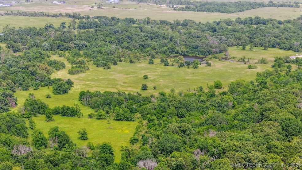
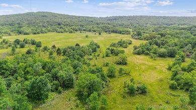
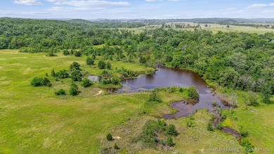
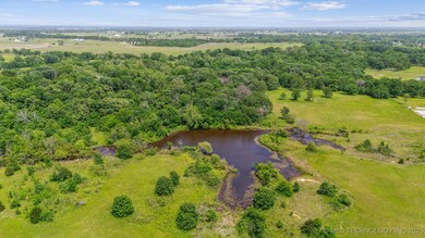
Are you ready to get out of the city?
Looking for a fresh start in an amazing area of Green Country?
Then look no further.

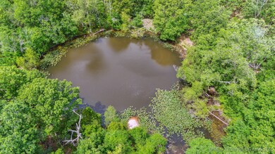
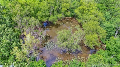
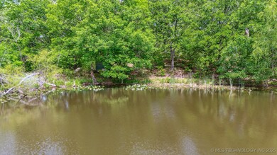
Check out this amazing 160 acres that includes 3 ponds. Featuring an estimated 27 acres of pasture land and roughly 133 acres of timber, this is an outdoorsman's paradise.

Whether you're looking for a private retreat, a recreational haven, or a future homestead, this land delivers endless possibilities for outdoor living and adventure.

Seller's are willing to possibly consider dividing the property.

Last Agent to Sell the Property

Robert Rhoads

Coldwell Banker Select License #207847 Listed on: 05/19/2025

Coldwell Banker Select

Last Buyer's Agent

Robert Rhoads

Coldwell Banker Select License #207847 Listed on: 05/19/2025

Coldwell Banker Select

Property Details

Property Type

  • Land

Est. Annual Taxes

  • $618

Lot Details

  • 160 Acre Lot
  • Property fronts a county road
  • Creek or Stream
  • Barbed Wire
  • Lot Has A Rolling Slope
  • Hilly Lot
  • Fruit Trees
  • Heavily Wooded Lot
  • Possible uses of the property include Farm, Ranch
  • Zoning described as AGR

Farming

  • 27 Acres of Pasture

Utilities

  • Water Not Available
  • Sewer Not Available

Community Details

Overview

  • Mayes Co Unplatted Subdivision

Recreation

  • Pond
  • Spring on Lot

Property Details

Property Type

Land

Est. Annual Taxes

$618

Lot Details

160 Acres

Listing Details

  • Directions: POB: INTERSECTION OF HWY 20 AND HWY 69 IN PRYOR. GO WEST ON HWY 20 APPROXIMATELY 5.5 MILES AND TURN RIGHT ONTO N426 ROAD. GO NORTH 0.9 MILES AND TURN RIGHT ONTO W480 RD. THIS IS THE SOUTHWEST CORNER OF THE PROPERTY. TURN LEFT IN 0.1 MILES (FIRST TURN TO THE LEFT) ONTO GRAVEL ROAD. IN 0.2 MILES THE WHITE HOUSE TO THE LEFT IS VISIBLE. THE HOME IS UNINHABITABLE. BUT IT IS ON THE PROPERTY. PROPERTY IS ON BOTH SIDES OF THE GRAVEL ROAD. PROPERTY'S SE SIDE ENDS AT N4265 RD AT DOUBLE GATE.
  • Prop. Type: Land
  • Lot Size Acres: 160.0
  • Road Frontage Type: County Road
  • Road Surface Type: Paved
  • Water Body Name: Hudson Lake
  • Subdivision Name: Mayes Co Unplatted
  • Special Features: None
  • Property Sub Type: LotsLands

Interior Features

  • Possible Use: Farm, Ranch

Exterior Features

  • Fencing: Barbed Wire
  • Lot Features: Fruit Trees, Pond on Lot, Rolling Slope, Stream/Creek, Spring, Acreage
  • Topography: Hill
  • Waterfront: No
  • Other Structures: Other

Utilities

  • Sewer: None
  • Utilities: Sewer Not Available, Water Not Available
  • Water Source: None

Schools

  • Junior High Dist: Osage - Grades K-8 (M7)

Lot Info

  • Current Use: Farm, Hunting, Ranch
  • Lot Size Sq Ft: 6969600.0
  • Pasture Area: 27.0
  • Wooded Area: 133.0
  • Additional Parcels: No
  • Zoning Description: AGR

Tax Info

  • Tax Year: 2024
  • Tax Annual Amount: 618.0
Create a Home Valuation Report for This Property
The Home Valuation Report is an in-depth analysis detailing your home's value as well as a comparison with similar homes in the area

Property History

Date Event Price List to Sale Price per Sq Ft
10/03/2025 10/03/25 Sold $740,000 -33.9% --
08/30/2025 08/30/25 Pending -- -- --
05/19/2025 05/19/25 For Sale $1,120,000 -- --
Source: MLS Technology

Agents Affiliated with this Home

  • Section Image
See All Agents

Map

Source: MLS Technology

MLS Number: 2521502

MLS Technology
Your Personal Tour Guide

Ask me questions while you tour the home.