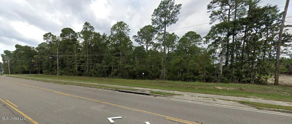
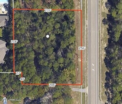
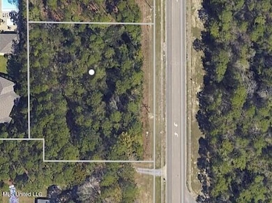
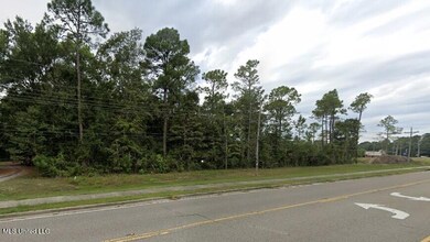
0 Jam Ln Biloxi, MS 39532
Estimated payment $2,914/month
Highlights
- 1.35 Acre Lot
- North Bay Elementary School Rated A
- Wooded Lot
About This Lot
Approximately 1.3 acres on Jam Lane in North Biloxi. Great opportunity to build your own building(s). Zoned Neighborhood Business. Close to Biloxi Junior High and Biloxi High School. Owner/Agent

Property Details
Property Type
- Land
Est. Annual Taxes
- $1,075
Lot Details
- 1.35 Acre Lot
- Wooded Lot
- Zoning described as Neighborhood Business
Community Details
- Property has a Home Owners Association
- Metes And Bounds Subdivision
Listing and Financial Details
- Assessor Parcel Number 1209c-02-003.005
Map
Home Values in the Area
Average Home Value in this Area
Tax History
| Year | Tax Paid | Tax Assessment Tax Assessment Total Assessment is a certain percentage of the fair market value that is determined by local assessors to be the total taxable value of land and additions on the property. | Land | Improvement |
|---|---|---|---|---|
| 2025 | $1,090 | $9,750 | $0 | $0 |
| 2024 | $1,080 | $9,750 | $0 | $0 |
| 2023 | $1,070 | $9,750 | $0 | $0 |
| 2022 | $1,070 | $9,750 | $0 | $0 |
| 2021 | $1,070 | $9,750 | $0 | $0 |
| 2020 | $1,071 | $9,750 | $0 | $0 |
| 2019 | $1,071 | $9,750 | $0 | $0 |
| 2018 | $1,071 | $9,750 | $0 | $0 |
| 2017 | $495 | $4,500 | $0 | $0 |
| 2015 | $495 | $4,500 | $0 | $0 |
Property History
| Date | Event | Price | List to Sale | Price per Sq Ft |
|---|---|---|---|---|
| 01/07/2026 01/07/26 | For Sale | $529,000 | 0.0% | -- |
| 12/31/2025 12/31/25 | Off Market | -- | -- | -- |
| 01/09/2025 01/09/25 | For Sale | $529,000 | -- | -- |
Purchase History
| Date | Type | Sale Price | Title Company |
|---|---|---|---|
| Warranty Deed | -- | -- |
Source: MLS United
MLS Number: 4100529
APN: 1209C-02-003.005
Disclaimer: Certain information contained herein is derived from information provided by parties other than Homes.com. All information provided is deemed reliable, but is not guaranteed to be accurate and should be independently verified.
![]() Information is deemed to be reliable but not guaranteed. Copyright 2026 MLS United, LLC.
Information is deemed to be reliable but not guaranteed. Copyright 2026 MLS United, LLC.
- 0 Popps Ferry Rd Unit 4138386
- 0 Popps Ferry Rd Unit 4108141
- 0 Popps Ferry Rd Unit 4108136
- 1985 Kornman Dr
- 712 Champagne Dr
- 694 Water's View Dr
- 2071 Stone Bridge Dr
- 2070 Camp Wilkes Rd
- 796 Sharon Hills Dr
- 856 Rustwood Dr
- 1884 Courtney Ln
- 0 Campbell Road Dr Unit 4027188
- 1910 Marsh Cove
- 2033 S Hill Dr
- 2106 Lauren Dr
- 5438 Leeds Ln
- 5505 Leeds Ln
- 5416 Leeds Ln
- 774 Sharon Hills Dr
- 757 Canterbury Dr
- 1955 Popps Ferry Rd
- 1850 Popps Ferry Rd
- 2110 Popps Ferry Rd
- 831 Cedar Lake Rd
- 1735 Tribe Dr
- 913 Motsie Rd
- 917 Motsie Rd
- 919 Motsie Rd
- 933 Motsie Rd
- 935 Motsie Rd
- 907 Motsie Rd
- 945 Motsie Rd
- 947 Motsie Rd
- 949 Motsie Rd
- 909 Motsie Rd
- 923 Motsie Rd
- 925 Motsie Rd
- 927 Motsie Rd
- 941 Motsie Rd
- 880 Motsie Rd Unit 880 Motsie Rd Biloxi MS 39532
Ask me questions while you tour the home.