NOT LISTED FOR SALE

0 Jefferson Hwy Unit VALA2000001 Mineral, VA 23117

82 Acres
-- Price per Acre
3,588,037 Sq Ft Lot

Last Sold November 06, 2023

Last sale price $465,000

735 Days on Market

Highlights

  • 962 Feet of Waterfront
  • Horses Allowed On Property
  • View of Trees or Woods
  • Thomas Jefferson Elementary School Rated A-
  • Fishing Allowed
  • 82.37 Acre Lot

About This Lot

As of November 2023

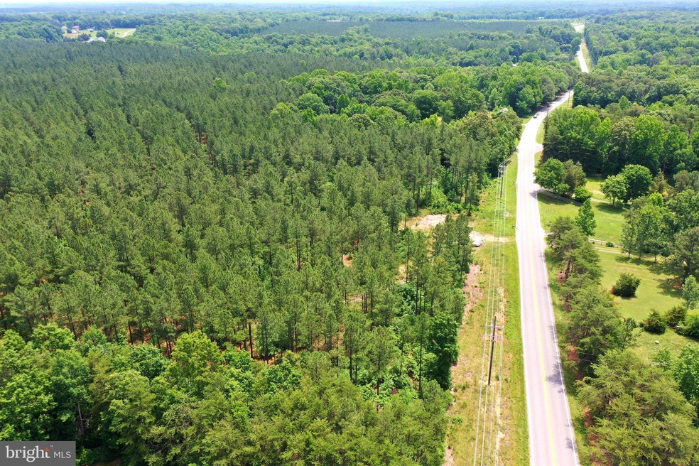
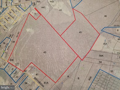
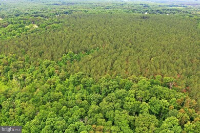
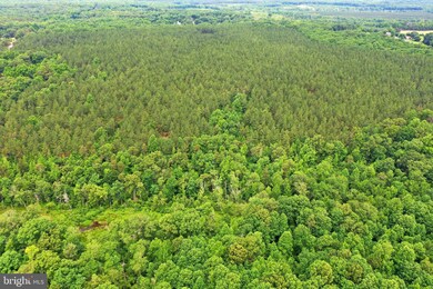
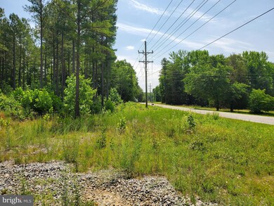
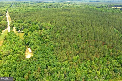
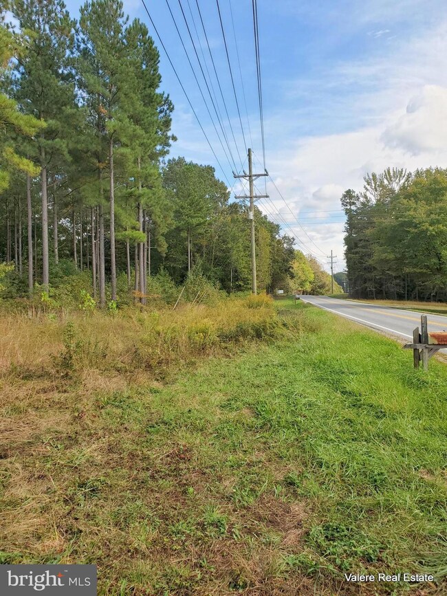
Prime central location! Two separate parcels totaling approximately 109.472 acres with 641 +/- feet of road frontage along Jefferson Highway (Route 33). Indian Creek weaves along the eastern boundary line of tax map parcel 59-45 (the 27.386-acre tract). Tax map parcel 59-43 totaling 82.086 +/- acres fronts Jefferson Highway. Zoned A2 with a timber crop in place consisting of planted pines on the 82.086 parcel with a recent 2021 estimate of clear-cutting value. Mixture of pine and some mature hardwoods are on the 27.386 parcel. Per Planning & Zoning, each parcel has 7 "By Right" divisions for a total of 14 division rights. There is a current survey of record of both parcels & a timber appraisal. Boundary lines have been recently marked/flagged. Aerial photos now available. Existing logging trail exists. An annual hunting lease in effect so show "By Appointment Only" during hunting season. Conveniently located to Towns of Mineral, Louisa, Montpelier & Lake Anna. Interstate 64 access is via either SR 605 (Shannon Hill Road - Exit 148) or SR 522 (Cross County Road - Exit 159 - Gum Springs). Multiple uses & possibilities. Within quarter mile of power sub-station. Call for plat prior to showing!

Last Agent to Sell the Property

Crystal Norbeck

Valere Real Estate License #0225036656 Listed on: 10/08/2021

Last Buyer's Agent

George Rosario

AKARION REALTY License #0225059350[611]

Property Details

Property Type

  • Land

Est. Annual Taxes

  • $1,876

Lot Details

  • 82.37 Acre Lot
  • 962 Feet of Waterfront
  • Creek or Stream
  • Partially Fenced Property
  • Wire Fence
  • Sloped Lot
  • Partially Wooded Lot
  • Additional Land
  • 59-45 (27.386 acres) for a total of 109.472 acres. New Survey 2021-22.
  • Property is zoned A2, Agricultural - Division Potential - 2 Parcels convey (59-43 and 59-45) for a total of 109.472 +/- acres.

Schools

  • Thomas Jefferson Elementary School
  • Louisa County Middle School
  • Louisa County High School

Utilities

  • Above Ground Utilities
  • Sewer Not Available

Additional Features

  • Views of Woods
  • Property is near a creek
  • Horses Allowed On Property

Listing and Financial Details

  • Tax Lot 43
  • Assessor Parcel Number 59 43

Community Details

Overview

  • No Home Owners Association

Recreation

  • Fishing Allowed
  • Water Access

Property Details

Property Type

Land

Est. Annual Taxes

$1,876

Lot Details

0

Listing Details

  • Property Type: Land
  • Property Sub Type: Land
  • Ownership: Fee Simple
  • Current Use: Timber, Hunting
  • Automatically Close On Close Date: No
  • Special Features: None
  • Stories: 0

Interior Features

  • Price Per Sq Ft: 0.14

Exterior Features

  • Construction Completed: No
  • Road Surface Type: Access - On Grade, Us Highway/Interstate
  • View: Trees/Woods
  • Water Access Features: Fishing Allowed
  • Water Access: Yes
  • Water Body Name: Indian Creek
  • Water Body Type: Creek/Stream
  • Waterfront: Yes
  • Water Oriented: Yes
  • Water View: No
  • Water Frontage In Feet: 962

Garage/Parking

  • Garage: No

Utilities

  • Central Air Conditioning: No
  • Sewer/Septic System: No Sewer System
  • Utilities: Above Ground
  • Internet Services: Other

Condo/Co-op/Association

  • HOA: No

Schools

  • School District: LOUISA COUNTY PUBLIC SCHOOLS
  • Elementary School: THOMAS JEFFERSON
  • Middle School: LOUISA COUNTY
  • High School: LOUISA COUNTY
  • Elementary School Source: Listing Agent
  • High School Source: Listing Agent
  • Middle School Source: Listing Agent
  • School District Key: 121139403138
  • School District Source: Listing Agent
  • Elementary School: THOMAS JEFFERSON
  • High School: LOUISA COUNTY
  • Middle Or Junior School: LOUISA COUNTY

Lot Info

  • Horses: Yes
  • Additional Parcels: Yes
  • Additional Parcels Description: 59-45 (27.386 acres) for a total of 109.472 acres. New Survey 2021-22.
  • Agricultural District: A2
  • Fencing: Wire, Partially
  • Horse Amenities: Horses Allowed
  • Land Use Code: 5
  • Lot Features: Additional Lot(s), Partly Wooded, Road Frontage, Sloping, Trees/Wooded
  • Lot Size Acres: 82.37
  • Lot Size Units: Square Feet
  • Lot Sq Ft: 3588037.20
  • Topography Description: Sloping terrain varies throughout the 2 parcels (gentle to moderate). Planted pine trees dominate on 82.373 acres and mixture of pines and some hardwoods on the 27.386 acre parcel.
  • Year Assessed: 2022
  • Zoning: A2
  • Zoning Description: Agricultural - Division Potential - 2 Parcels convey (59-43 and 59-45) for a total of 109.472 +/- acres.
  • Farmland Preservation: No
  • In City Limits: No

Rental Info

  • Lease In Effect: Yes
  • Vacation Rental: No

Tax Info

  • Tax Annual Amount: 1876.00
  • Assessor Parcel Number: 59 43
  • Tax Lot: 43
  • County Tax Payment Frequency: Annually
  • Tax Data Updated: No
  • Tax Year: 2022
  • Close Date: 11/06/2023

MLS Schools

  • School District Name: LOUISA COUNTY PUBLIC SCHOOLS

Range of Values:

Collateral Analytics

Collateral Analytics Collateral Analytics AVMs (Automated Valuation Model) employ a number of statistical approaches combined with neighborhood-specific comparable selection guarantees the most up-to-date and precise valuations.

Not Available

Collateral Analytics does not have data for the current month. Please view the chart for historical values.

ICE

ICE Mortgage Technology ICE Mortgage Technology’s AVM (Automated Valuation Model) is a state-of-the-art online residential property valuation tool that provides a quick and accurate estimate of the value of almost any home in the U.S.

Not Available

ICE Mortgage Technology does not have data for the current month. Please view the chart for historical values.

First American

First American First American Data & Analytics’ next-generation AVM combines unrivaled data assets with a blended ensemble of valuation models to produce highly accurate, reliable valuations you can trust.

Not Available

First American does not have data for the current month. Please view the chart for historical values.

Quantarium

Quantarium Quantarium’s valuation service, repeatedly proven the industry’s most accurate and comprehensive, is supercharged with a self-learning and auto-tuning AI engine that continually becomes smarter and more accurate as it processes daily inputs from the industry’s leading RE data lake.

Not Available

Quantarium does not have data for the current month. Please view the chart for historical values.

Average Value
Not Available
List Price
Sold Price
Create a Home Valuation Report for This Property
The Home Valuation Report is an in-depth analysis detailing your home's value as well as a comparison with similar homes in the area

Home Values in the Area

Source: Public Records

Average Home Value in this Area


Source: Public Records

Property History

Date Event Price Change Sq Ft Price
11/06/2023 11/06/23 Sold $465,000 -4.1% --
10/13/2023 10/13/23 Pending -- -- --
09/09/2022 09/09/22 Price Changed $485,000 -17.1% --
05/26/2022 05/26/22 Price Changed $585,000 -6.4% --
03/31/2022 03/31/22 Price Changed $625,000 -9.2% --
10/08/2021 10/08/21 For Sale $688,500 -- --
Source: Bright MLS

Tax History Compared to Growth

Source: Public Records

Agents Affiliated with this Home

  • Section Image
  • Section Image
See All Agents

Map

Source: Bright MLS

MLS Number: VALA2000001

Bright MLS