
Estimated payment $868/month
About This Lot
Classified as Lots and Land Area. Uses of adjacent areas Row Crops, Residential, church. Easements. Public Water, Electricity, Natural Gas.
Property Details
Property Type
- Land
Lot Details
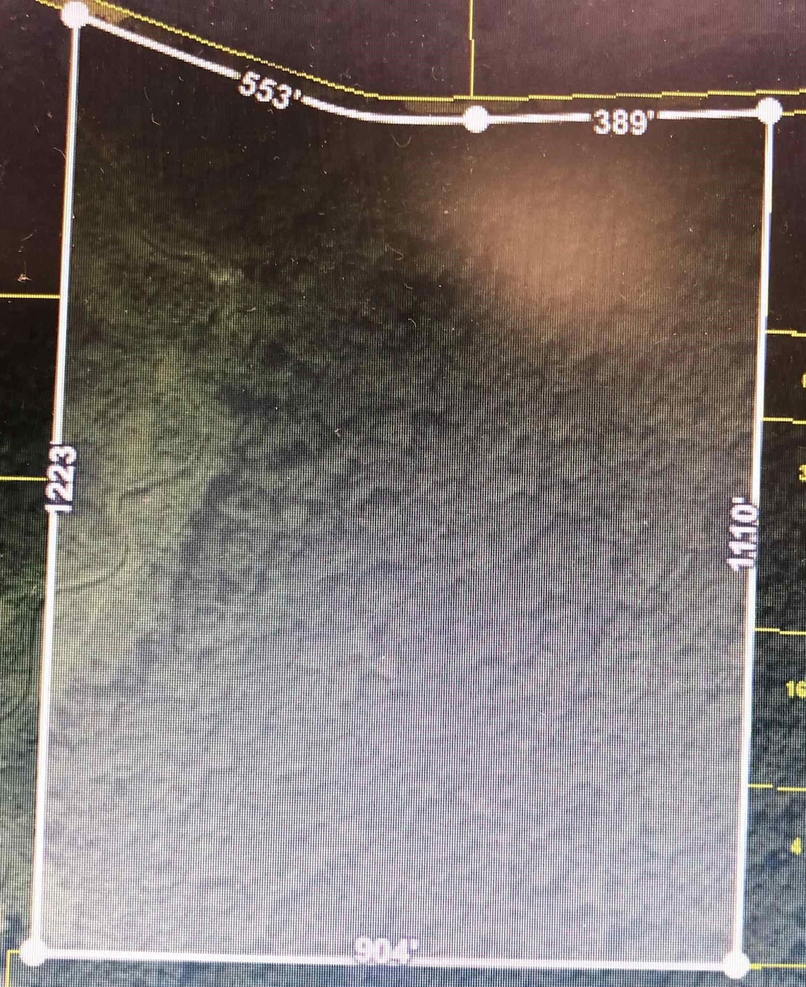
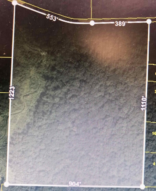
- 23.5 Acre Lot
- Rural Setting
- Lot Has A Rolling Slope
- Wooded Lot
- Property is zoned Rural
Basement
- Drainage System
Community Details
- Mason Malone Subdivision
Listing and Financial Details
- Assessor Parcel Number 106 017.00 000 23.5 Acres Off Hwy 59 on Mason Malone Rd
Map
Home Values in the Area
Average Home Value in this Area
Property History
| Date | Event | Price | List to Sale | Price per Sq Ft |
|---|---|---|---|---|
| 06/24/2025 06/24/25 | Price Changed | $139,000 | -6.7% | -- |
| 05/28/2025 05/28/25 | Price Changed | $149,000 | -11.8% | -- |
| 04/07/2025 04/07/25 | For Sale | $169,000 | -- | -- |
Source: Memphis Area Association of REALTORS®
MLS Number: 10193787
Disclaimer: Certain information contained herein is derived from information provided by parties other than Homes.com. All information provided is deemed reliable, but is not guaranteed to be accurate and should be independently verified.
![]() Listing content and images Copyright 2025 Memphis Area Association of REALTORS®. Information provided is for the consumer’s personal, non-commercial use and may not be used for any purpose other than to identify prospective properties consumers may be interested in purchasing. Do not rely upon listing data without independently verifying it.
Listing content and images Copyright 2025 Memphis Area Association of REALTORS®. Information provided is for the consumer’s personal, non-commercial use and may not be used for any purpose other than to identify prospective properties consumers may be interested in purchasing. Do not rely upon listing data without independently verifying it.
Some or all of the listings displayed may not belong to the firm whose website is being visited.
- 0 Hwy 59 Hwy Unit 10189659
- 0 Hwy 59 Hwy Unit 10189658
- 0 Route 59
- 18257 Route 59
- 4374 Gainsville Rd
- 375 Emmitt Culberth Ln
- 835 Robertson Rd
- 0 Pickens Store Rd
- LOT 1 Brammer Rd
- LOT 8 Brammer Rd
- 112 Taylor Ln
- 0 Route 59
- 15225 U S 70
- 30 Highway 70 E
- 428 Hogan Rd
- TRact #1 Hwy 79 N
- 12112 Main St
- 5500 Charleston Mason Rd
- 39 Washington Ave
- 0 Gainsville Rd
- 111 Templeton Rd
- 12 Villa Ln
- 47 Sean Cove
- 1150 Simonton St
- 148 Nugget Ln
- 443 Beverly Dr
- 12214 Mary Alice Dr
- 8217 Penny Ln
- 12435 Garrett Valley Place
- 6029 Marley St
- 5707 Chester St
- 90 Webster Cove
- 129 Boardwalk St
- 5767 Lillian Bend Dr
- 5452 Belle Ridge Dr
- 11635 Dempsey Dr
- 5396 Mahogany Ridge Dr
- 11603 Dempsey Dr
- 61 Franklin Square Dr
- 11215 Ram Hill Cove
