L
Seller's Agent in 2020
Linda Johnston
Alpine Real Estate


Estimated Value: $195,000 - $395,000
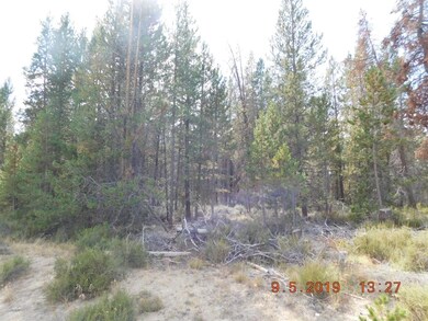
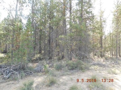
Beautiful 3.96 acre lot in North Klamath County. This would be a great home site, horse property, lots of room for most anything. Area of good wells and standard septic's. Call your Realtor today for more information.
Last Agent to Sell the Property
Linda Johnston
Alpine Real Estate License #940500122 Listed on: 09/06/2019
Co-Listed By
Dianne Willis
High Lakes Realty & Property M License #990600089
Last Buyer's Agent
Christina Tsutsui-Tharp
Bend Dreams Realty LLC License #201225630
| Date | Buyer | Sale Price | Title Company |
|---|---|---|---|
| Skinner Robert B | $60,000 | None Available |
| Date | Event | Price | List to Sale | Price per Sq Ft |
|---|---|---|---|---|
| 09/25/2020 09/25/20 | Sold | $85,000 | -14.1% | -- |
| 08/11/2020 08/11/20 | Pending | -- | -- | -- |
| 09/05/2019 09/05/19 | For Sale | $98,900 | -- | -- |
| Year | Tax Paid | Tax Assessment Tax Assessment Total Assessment is a certain percentage of the fair market value that is determined by local assessors to be the total taxable value of land and additions on the property. | Land | Improvement |
|---|---|---|---|---|
| 2025 | $734 | $58,640 | -- | -- |
| 2024 | $705 | $56,940 | -- | -- |
| 2023 | $681 | $56,940 | $0 | $0 |
| 2022 | $617 | $53,680 | $0 | $0 |
| 2021 | $181 | $16,420 | $0 | $0 |
| 2020 | $176 | $15,950 | $0 | $0 |
| 2019 | $172 | $15,490 | $0 | $0 |
| 2018 | $172 | $15,490 | $0 | $0 |
| 2017 | $172 | $15,400 | $0 | $0 |
| 2016 | $168 | $14,960 | $0 | $0 |
| 2015 | $164 | $14,530 | $0 | $0 |
| 2014 | $157 | $14,110 | $0 | $0 |
| 2013 | -- | $13,700 | $0 | $0 |
L
Seller's Agent in 2020
Linda Johnston
Alpine Real Estate
D
Seller Co-Listing Agent in 2020
Dianne Willis
High Lakes Realty & Property M
C
Buyer's Agent in 2020
Christina Tsutsui-Tharp
Bend Dreams Realty LLC
Source: Oregon Datashare
MLS Number: 201908641
APN: R136409
Disclaimer: Certain information contained herein is derived from information provided by parties other than Homes.com. All information provided is deemed reliable, but is not guaranteed to be accurate and should be independently verified.
![]() © 2026 Oregon Datashare (KCAR | MLSCO | SOMLS). All rights reserved. The data relating to real estate for sale on this web site comes in part from the Internet Data Exchange Program of the Oregon Datashare. Real estate listings held by IDX Brokerage firms other than Ten-X are marked with the Internet Data Exchange logo or the Internet Data Exchange thumbnail logo and detailed information about them includes the name of the listing Brokers. Information provided is for consumers' personal, non-commercial use and may not be used for any purpose other than to identify prospective properties the viewer may be interested in purchasing. The consumer will not copy, retransmit nor redistribute any of the content from this website. Information provided is deemed reliable, but not guaranteed.
© 2026 Oregon Datashare (KCAR | MLSCO | SOMLS). All rights reserved. The data relating to real estate for sale on this web site comes in part from the Internet Data Exchange Program of the Oregon Datashare. Real estate listings held by IDX Brokerage firms other than Ten-X are marked with the Internet Data Exchange logo or the Internet Data Exchange thumbnail logo and detailed information about them includes the name of the listing Brokers. Information provided is for consumers' personal, non-commercial use and may not be used for any purpose other than to identify prospective properties the viewer may be interested in purchasing. The consumer will not copy, retransmit nor redistribute any of the content from this website. Information provided is deemed reliable, but not guaranteed.
Ask me questions while you tour the home.
