
0 Middle Creek Rd Unit 35 Acres Land Sandy Hook, KY 41171
Estimated payment $637/month
Highlights
- 35 Acre Lot
- Wooded Lot
- Level Lot
- Hilly Lot
- Agricultural
About This Lot
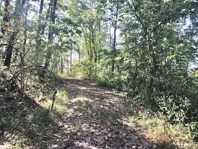
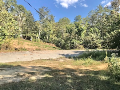
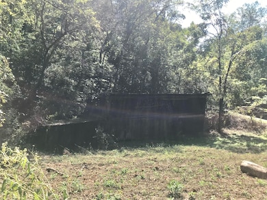
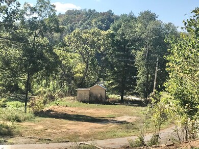
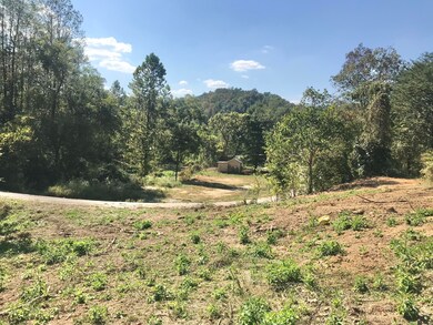
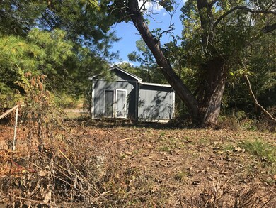
This 35-acre unrestricted property is located in Sandy Hook, KY, with convenient road frontage on both Highway 32 and Middle Fork Road. The land features varied elevations ranging from 700 to 1,040 feet, offering diverse terrain and scenic views. Utilities include electric access on-site (not currently connected) and an existing water meter. The property also includes several structures: a storage shed, an open shed barn, and the site of an old home that is no longer livable. A small cemetery is located on the land as well. With old roads and trails winding through the property, it's an excellent location for a homesite, recreational use, or hunting. The land was partially logged less than two years ago, making it more accessible while retaining its natural character.
Property Details
Property Type
- Land
Est. Annual Taxes
- $72
Lot Details
- 35 Acre Lot
- Level Lot
- Irregular Lot
- Hilly Lot
- Wooded Lot
- Property is zoned AR
Farming
- Agricultural
Community Details
- Rural Subdivision
Listing and Financial Details
- Assessor Parcel Number 039-00-00-014.00
Map
Home Values in the Area
Average Home Value in this Area
Tax History
| Year | Tax Paid | Tax Assessment Tax Assessment Total Assessment is a certain percentage of the fair market value that is determined by local assessors to be the total taxable value of land and additions on the property. | Land | Improvement |
|---|---|---|---|---|
| 2024 | $72 | $7,287 | $0 | $0 |
| 2023 | $67 | $6,905 | $6,905 | $0 |
| 2022 | $67 | $6,905 | $0 | $0 |
| 2021 | $66 | $6,905 | $0 | $0 |
| 2020 | $50 | $5,200 | $0 | $0 |
| 2019 | $50 | $5,200 | $0 | $0 |
| 2018 | $53 | $5,200 | $0 | $0 |
| 2017 | $52 | $5,200 | $0 | $0 |
| 2016 | $0 | $5,200 | $0 | $0 |
| 2015 | -- | $5,200 | $0 | $0 |
| 2014 | -- | $5,200 | $0 | $0 |
Property History
| Date | Event | Price | List to Sale | Price per Sq Ft |
|---|---|---|---|---|
| 09/21/2025 09/21/25 | For Sale | $119,900 | -- | -- |
Purchase History
| Date | Type | Sale Price | Title Company |
|---|---|---|---|
| Deed | $1,500 | None Listed On Document | |
| Warranty Deed | $92,000 | None Listed On Document |
Source: ImagineMLS (Bluegrass REALTORS®)
MLS Number: 25501880
APN: 039-00-00-014.00
Disclaimer: Certain information contained herein is derived from information provided by parties other than Homes.com. All information provided is deemed reliable, but is not guaranteed to be accurate and should be independently verified.
![]() The information is being provided by LBAR Multiple Listing Service. Information deemed reliable but not guaranteed. Information is provided for consumers' personal, non-commercial use, and may not be used for any purpose other than the identification of potential properties for purchase. Copyright 2025 LBAR Multiple Listing Service. All Rights Reserved.
The information is being provided by LBAR Multiple Listing Service. Information deemed reliable but not guaranteed. Information is provided for consumers' personal, non-commercial use, and may not be used for any purpose other than the identification of potential properties for purchase. Copyright 2025 LBAR Multiple Listing Service. All Rights Reserved.
- 0 Middle Fork Rd
- 0 Greene Unit 58004
- 3076 Sheepskin Rd
- 7515 S Kentucky 32
- 566 Kentucky 7 Unit 13,14,15 &16
- 7000 Kentucky 7
- 45 Mobley Spur Rd
- 2274 S Ky 7
- 263 Mays Rd
- 2639 Kentucky 7
- 227 Lewis Rd
- 0000 Beech Grove Rd
- 81 Beech Grove Rd
- 5800 Ky 719
- 142 Rd
- 293 Ora Stevens
- 950 Green Branch Rd
- 3320 Wells Creek Rd
- 1502 Turkey Branch Rd
- 91 Acres Land Cains Creek Rd
