
0 N 3083 Rd Unit 50791453 Conroe, TX 77303
Estimated payment $15,358/month
About This Lot
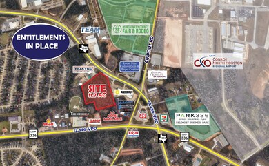
Located in the booming Conroe market across the street from Conroe Park North Industrial Park, which is a 1,656 acre development owned by the City of Conroe EDC that is home to international, national, and regional users including AirGas, Bauer Pileco, FedEx Freight, Five Below, NOV, and McKesson. The Landing at 3083 is an 11.7 acre tract of land that has had entitlements performed which include survey, topo, TXdot driveway permit, full civil construction drawings, and pre-liminary plat approval for a 100,000 sqft industrial park. Located on FM 3083 which was recently expanded to four-lane road and only 3 miles to I-45 and 1/4 mile to Loop 336.
Property Details
Property Type
- Land
Est. Annual Taxes
- $23,298
Lot Details
- 11.7 Acre Lot
- Heavily Wooded Lot
- Additional Parcels
Schools
- Anderson Elementary School
- Stockton Junior High School
- Conroe High School
Community Details
- Allen W S Subdivision
Map
Home Values in the Area
Average Home Value in this Area
Tax History
| Year | Tax Paid | Tax Assessment Tax Assessment Total Assessment is a certain percentage of the fair market value that is determined by local assessors to be the total taxable value of land and additions on the property. | Land | Improvement |
|---|---|---|---|---|
| 2025 | $21,491 | $1,123,336 | $1,123,336 | -- |
| 2024 | $21,527 | $1,123,340 | $1,123,340 | -- |
| 2023 | $21,527 | $1,123,340 | $1,123,340 | $0 |
| 2022 | $23,298 | $1,123,340 | $1,123,340 | $0 |
| 2021 | $24,560 | $1,123,340 | $1,123,340 | $0 |
| 2020 | $4,707 | $206,310 | $206,310 | $0 |
| 2019 | $7,818 | $335,250 | $335,250 | $0 |
| 2018 | $7,818 | $335,250 | $335,250 | $0 |
| 2017 | $7,848 | $335,250 | $335,250 | $0 |
| 2016 | $7,848 | $335,250 | $335,250 | $0 |
| 2015 | $5,413 | $229,630 | $229,630 | $0 |
| 2014 | $5,413 | $229,630 | $229,630 | $0 |
Property History
| Date | Event | Price | List to Sale | Price per Sq Ft |
|---|---|---|---|---|
| 08/15/2023 08/15/23 | For Sale | $2,550,438 | -- | -- |
Purchase History
| Date | Type | Sale Price | Title Company |
|---|---|---|---|
| Warranty Deed | -- | Old Republic Title | |
| Deed | -- | -- |
Source: Houston Association of REALTORS®
MLS Number: 50791453
APN: 0002-01-00330
Disclaimer: Certain information contained herein is derived from information provided by parties other than Homes.com. All information provided is deemed reliable, but is not guaranteed to be accurate and should be independently verified.
![]() Copyright 2025, Houston REALTORS® Information Service, Inc.
Copyright 2025, Houston REALTORS® Information Service, Inc.
The information provided is exclusively for consumers’ personal, non-commercial use, and may not be used for any purpose other than to identify prospective properties consumers may be interested in purchasing.
Information is deemed reliable but not guaranteed.
- 12242 N Chestnut Hills Dr
- 4005 Hunnington Dr
- 7 Ollerton Dr
- 229 Oxford Dr
- 2947 N Loop 336 E
- 206 Doncaster St
- 1908 Northampton Dr
- 235 Doncaster St
- 200 Canterbury Dr
- 1039 Blue Moon Ct
- 3212 Bushy Hawthorne Dr
- 3215 Bushy Hawthorne Dr
- 3219 Bushy Hawthorne Dr
- 3211 Bushy Hawthorne Dr
- 3207 Bushy Hawthorne Dr
- 3231 Bushy Hawthorne Dr
- 3208 Bushy Hawthorne Dr
- 3203 Bushy Hawthorne Dr
- 1317 Mount Bassie Trail
- 2259 Middle Ridge Dr
- 1110 Shadow Glenn Dr
- 2075 Briar Grove Dr
- 208 Canterbury Dr
- 1929 Briar Grove Dr
- 851 Arbor Pines Ct
- 1937 Briar Grove Dr
- 2022 Midlane Dr
- 1053 Shadow Glenn Dr
- 2035 Emmons Cliff Trail
- 1112 Copal Trail
- 1208 Narrow Heights Dr
- 1317 Mount Bassie Trail
- 1329 Mount Blanc Path
- 1409 Mount Bassie Trail
- 1401 Mount Blanc Path
- 504 N Magnolia Dr
- 13310 Rayhill Dr
- 1435 Cecilia Vines Dr
- 522 Belle Springs Ln
- 15531 Caramel Springs Dr
