
0 Old Us 52 Rd Unit 202511913 Laurel, IN 47024
Estimated payment $1,863/month
About This Lot
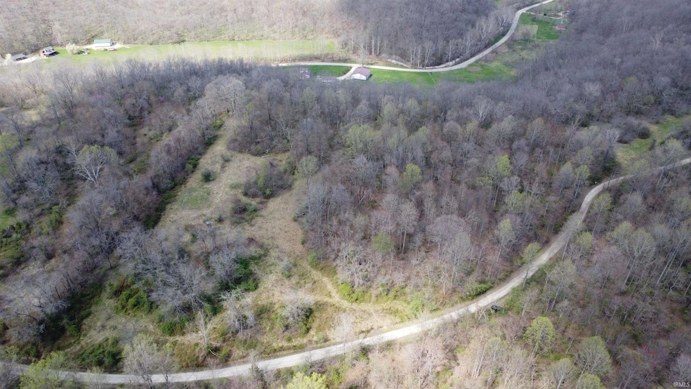
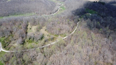
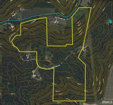
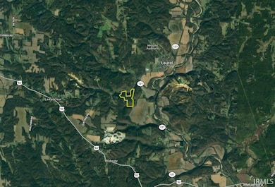
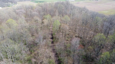
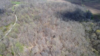
Are you looking for peace and quiet in rural Indiana? This property is it! Located just south of Laurel, the core of this property sits high on a ridge top with great access throughout. There is frontage off of old 52 with access to electric and Red Oak Lane goes through the property's center allowing easy driving to the top of the property. There are a couple of nice homesteads along red oak lane so electric access is not far off on top too. There are a couple of big openings that were used as wildlife food plots in the past on the north side of the lane. This section is where the current owner did a lot of hunting. There is an existing trail system and with a little bit of clearing work more could easily be made. The south portion is all wooded but has a great road/trail that takes you to the eastern border. From here the views to the south are amazing. Along the south side it is sloped to the bottom but there are a couple of nice benches that create funnels for deer movement or easy walking access as well as a ravine from top to bottom, offering another pinch point. If you are interested in less land, confirm with the listing agent as there may be an opportunity for that.
Listing Agent
Whitetail Properties Real Estate Brokerage Phone: 219-242-2701 Listed on: 04/09/2025

Property Details
Property Type
- Land
Est. Annual Taxes
- $216
Lot Details
- 59 Acre Lot
- Lot Dimensions are 1728' x 2400'
- Property fronts a state road
- Finished Lot(s)
- Subdivision Possible
Parking
- Driveway
Schools
- Laurel Elementary And Middle School
- Franklin High School
Additional Features
- Agricultural
- Well Required
Listing and Financial Details
- Assessor Parcel Number 24-02-17-400-001.006-010
Map
Home Values in the Area
Average Home Value in this Area
Property History
| Date | Event | Price | List to Sale | Price per Sq Ft |
|---|---|---|---|---|
| 08/21/2025 08/21/25 | Price Changed | $350,000 | -6.7% | -- |
| 05/12/2025 05/12/25 | Price Changed | $375,000 | -6.0% | -- |
| 04/09/2025 04/09/25 | For Sale | $399,000 | -- | -- |
Source: Indiana Regional MLS
MLS Number: 202511913
Disclaimer: Certain information contained herein is derived from information provided by parties other than Homes.com. All information provided is deemed reliable, but is not guaranteed to be accurate and should be independently verified.
![]() IDX information is provided exclusively for personal, non-commercial use, and may not be used for any purpose other than to identify prospective properties consumers may be interested in purchasing. Information is deemed reliable but not guaranteed.
IDX information is provided exclusively for personal, non-commercial use, and may not be used for any purpose other than to identify prospective properties consumers may be interested in purchasing. Information is deemed reliable but not guaranteed.
- 0 Old Us 52 Rd Unit LotWP001 23171557
- 0 Old Us 52 Rd Unit 202518802
- 0 Old Us 52 Rd Unit LotWP001 23615955
- 0 Red Oak Ln
- 0 Red Oak Ln Unit LotWP001 23615956
- 225 Marshall St
- 131 Charles St
- 259 W Main St
- 182 Cass St
- 121 W Main St
- 211 Basin St
- 174 Commerce St
- 154 Pearl St
- 23041 U S 52
- 127 E Baltimore St
- 122 Baltimore St
- 244 Baltimore St
- 1139 Tekulve Rd
- 315 E Pearl St
- 23 Oakmont Place
- 3600 Western Ave
- 1461 W Daniel Dr Unit 1506
- 136 Bryan St
- 100 W Main St Unit Apartment 3
- 5201 College Corner Pike
- 6101 Contreras Rd Unit 2
- 610 Oxford Commons
- 615 Ogden Ct
- 15 N Locust St Unit C
- 271 Reagan Place
- 98 W Central Ave
- 98 W Central Ave
- 98 W Central Ave
- 98 W Central Ave
- 5262 Brown Rd
- 518 S Main St
- 3 E Central Ave Unit 2B By MU Health Science