


0 Westwood Rd NW Liberty Township, OH 43105
Estimated payment $1,861/month
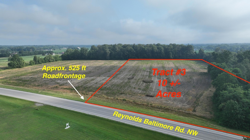
About This Lot
This 10-acre tract offers incredible potential with its current B-1 (Small Scale Commercial) zoning, making it ideal for a variety of permitted business uses or continued agricultural production. Conveniently located along Route 256 between Pickerington and Baltimore, this property features approximately 525 feet of road frontage on State Route 256 ( Reynoldsburg - Baltimore Rd ) and includes a dedicated access easement for added accessibility.
Currently used as premium tillable farmland, this parcel provides opportunities for business income, investment, or future development. Buyers are encouraged to review the Violet Township B-1 Zoning Resolution—available in the listing documents—for a full list of permitted uses.
Please note, public water and sewer are not available; the property will require private well and septic systems.
Whether you're looking for commercial potential, agricultural income, or a strategic investment, this property stands out with its flexible zoning and prime location.
Property Details
Property Type
- Land
Est. Annual Taxes
- $1,577
Lot Details
- 10 Acre Lot
Home Design
- Mixed Use
Listing and Financial Details
- Assessor Parcel Number 02-10054-300
Map
Home Values in the Area
Average Home Value in this Area
Tax History
| Year | Tax Paid | Tax Assessment Tax Assessment Total Assessment is a certain percentage of the fair market value that is determined by local assessors to be the total taxable value of land and additions on the property. | Land | Improvement |
|---|---|---|---|---|
| 2024 | $2,679 | $35,830 | $35,830 | -- |
| 2023 | $1,399 | $123,460 | $123,460 | -- |
| 2022 | $1,388 | $123,460 | $123,460 | $0 |
| 2021 | $1,391 | $112,230 | $112,230 | $0 |
| 2020 | $1,518 | $123,150 | $123,150 | $0 |
| 2019 | $1,568 | $122,500 | $122,500 | $0 |
| 2018 | $2,603 | $113,970 | $113,970 | $0 |
| 2017 | $2,616 | $113,970 | $113,970 | $0 |
| 2016 | $2,613 | $115,930 | $115,930 | $0 |
| 2015 | $2,110 | $115,930 | $115,930 | $0 |
| 2014 | $4,442 | $183,540 | $145,750 | $37,790 |
| 2013 | $4,442 | $183,540 | $145,750 | $37,790 |
Property History
| Date | Event | Price | Change | Sq Ft Price |
|---|---|---|---|---|
| 07/21/2025 07/21/25 | For Sale | $320,000 | -46.7% | -- |
| 07/21/2025 07/21/25 | For Sale | $600,000 | -54.7% | -- |
| 07/21/2025 07/21/25 | For Sale | $1,325,000 | +65.9% | -- |
| 07/21/2025 07/21/25 | For Sale | $798,750 | -- | -- |
Purchase History
| Date | Type | Sale Price | Title Company |
|---|---|---|---|
| Special Warranty Deed | -- | None Listed On Document | |
| Warranty Deed | $58,000 | Northwest Title | |
| Survivorship Deed | $58,000 | None Available | |
| Warranty Deed | -- | Vandervoort Jeffrey K | |
| Quit Claim Deed | -- | Attorney | |
| Deed | -- | Attorney | |
| Interfamily Deed Transfer | -- | -- | |
| Interfamily Deed Transfer | -- | -- |
Mortgage History
| Date | Status | Loan Amount | Loan Type |
|---|---|---|---|
| Open | $610,000 | New Conventional | |
| Previous Owner | $436,168 | Construction |
Source: Columbus and Central Ohio Regional MLS
MLS Number: 225027043
APN: 02-10054-300
Disclaimer: Certain information contained herein is derived from information provided by parties other than Homes.com. All information provided is deemed reliable, but is not guaranteed to be accurate and should be independently verified.
![]() IDX information is provided exclusively for personal, non-commercial use, and may not be used for any purpose other than to identify prospective properties consumers may be interested in purchasing.
IDX information is provided exclusively for personal, non-commercial use, and may not be used for any purpose other than to identify prospective properties consumers may be interested in purchasing.
Information is deemed reliable but not guaranteed.
- 9480 Heimberger Rd NW
- 5635 Reynoldsburg Baltimore Rd NW
- 5675 Bickel Church Rd NW
- 10415 Stoudertown Rd NW
- 5810 Bickel Church Rd NW
- 9585 Snyder Church Rd NW
- 9941 Doty Rd NW
- 0 Doty Rd NW Unit 224043718
- 0 Doty Rd NW Unit 224043669
- 10959 Heimberger Rd NW
- 11290 Stoudertown Rd NW
- 0 Heimberger Rd NW Unit 224007682
- 6940 Reynoldsburg Baltimore Rd NW
- 0 Heimberger Ln NW
- 10492 Allen Rd
- 11099 Keswick Dr NW
- 5640 Refugee Rd NW
- 5952 Refugee Rd NW
- 145 Shawnee Dr
- 11774 Kennington Square E
- 7271 Refugee
- 228 N Yencer St Unit C
- 224 N Yencer St
- 351 W Fairview Ave
- 55 W Columbus St
- 614 N Main St
- 73 W Columbus St Unit 73 W Columbus Street
- 516 Longview St
- 512 Longview St
- 280 Autumn Ridge Cir
- 8044 Rapala Ln
- 8608 Ashford Ln NW
- 150 Lakepoint Ct
- 662 Cherry Hill Dr
- 235 Evergreen Ct
- 90 Knights Bridge Dr N
- 602 Redbud Rd
- 206 Pioneer Cir Unit 206
- 136 Leasure Dr
- 12338 Woodsfield Place
