P
Seller's Agent in 2015
Philip Rotondo
Coldwell Banker Res. R.E.
Estimated Value: $350,000 - $376,000
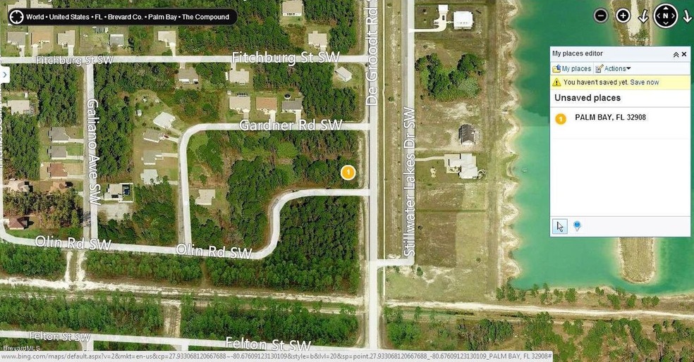
1 of 4 contiguous lots that form a square (2 corner lots, 2 adjacent lots) available in Port Malabar Unit #31 of SW Palm Bay. 206 Garnder, DeGroodt & Gardner, DeGroodt & Olin, and 215 Olin. Great Location in the SW Section of Palm Bay with city water availability. 2.9 miles -6 minutes- to Publix Shopping, 1.2 miles -2 minutes- to Bayside High and Westside Elementary Schools, 18 miles -30 minutes- to the Indialantic Beach, and just 70.2 miles -65 minutes- to Orlando Int'l Airport. Lots zoned SRE for minimum 1800 sq.ft. home. From Exit #176 of I-95, go west on Palm Bay Road NE. Turn left on Minton Road and proceed south for 3.4 miles. Turn right on Jupiter Boulevard SW and left on Degroodt Road SW. Proceed south for 3.8 miles to Gardner. The next block south is Olin
Last Agent to Sell the Property
Philip Rotondo
Coldwell Banker Res. R.E. Listed on: 11/26/2014
Last Buyer's Agent
Philip Rotondo
Coldwell Banker Res. R.E. Listed on: 11/26/2014
| Date | Buyer | Sale Price | Title Company |
|---|---|---|---|
| Dor Mirville | $371,200 | None Listed On Document | |
| Dor Mirville | $371,200 | None Listed On Document | |
| Cui Long | $161,100 | None Available |
| Date | Status | Borrower | Loan Amount |
|---|---|---|---|
| Open | Dor Mirville | $321,150 | |
| Closed | Dor Mirville | $321,150 |
| Date | Event | Price | Change | Sq Ft Price |
|---|---|---|---|---|
| 03/31/2015 03/31/15 | Sold | $4,625 | -7.5% | -- |
| 02/12/2015 02/12/15 | Pending | -- | -- | -- |
| 11/26/2014 11/26/14 | For Sale | $5,000 | -- | -- |
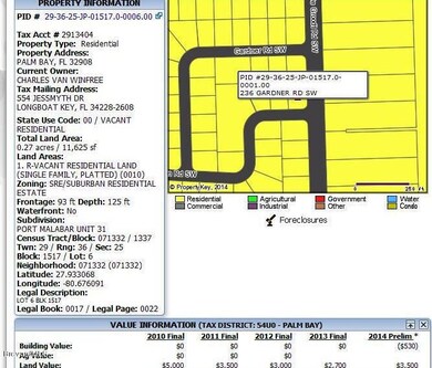
| Year | Tax Paid | Tax Assessment Tax Assessment Total Assessment is a certain percentage of the fair market value that is determined by local assessors to be the total taxable value of land and additions on the property. | Land | Improvement |
|---|---|---|---|---|
| 2024 | $369 | $264,670 | -- | -- |
| 2023 | $369 | $35,000 | $0 | $0 |
| 2022 | $249 | $19,000 | $0 | $0 |
| 2021 | $199 | $10,000 | $10,000 | $0 |
| 2020 | $173 | $7,500 | $7,500 | $0 |
| 2019 | $228 | $7,500 | $7,500 | $0 |
| 2018 | $213 | $6,400 | $6,400 | $0 |
| 2017 | $193 | $1,250 | $0 | $0 |
| 2016 | $118 | $4,500 | $4,500 | $0 |
| 2015 | $108 | $4,000 | $4,000 | $0 |
| 2014 | $90 | $3,500 | $3,500 | $0 |
P
Seller's Agent in 2015
Philip Rotondo
Coldwell Banker Res. R.E.
Source: Space Coast MLS (Space Coast Association of REALTORS®)
MLS Number: 712085
APN: 29-36-25-JP-01517.0-0006.00
Disclaimer: Certain information contained herein is derived from information provided by parties other than Homes.com. All information provided is deemed reliable, but is not guaranteed to be accurate and should be independently verified.
![]() IDX information is provided exclusively for personal, non-commercial use, and may not be used for any purpose other than to identify prospective properties consumers may be interested in purchasing.
IDX information is provided exclusively for personal, non-commercial use, and may not be used for any purpose other than to identify prospective properties consumers may be interested in purchasing.
Information is deemed reliable but not guaranteed.