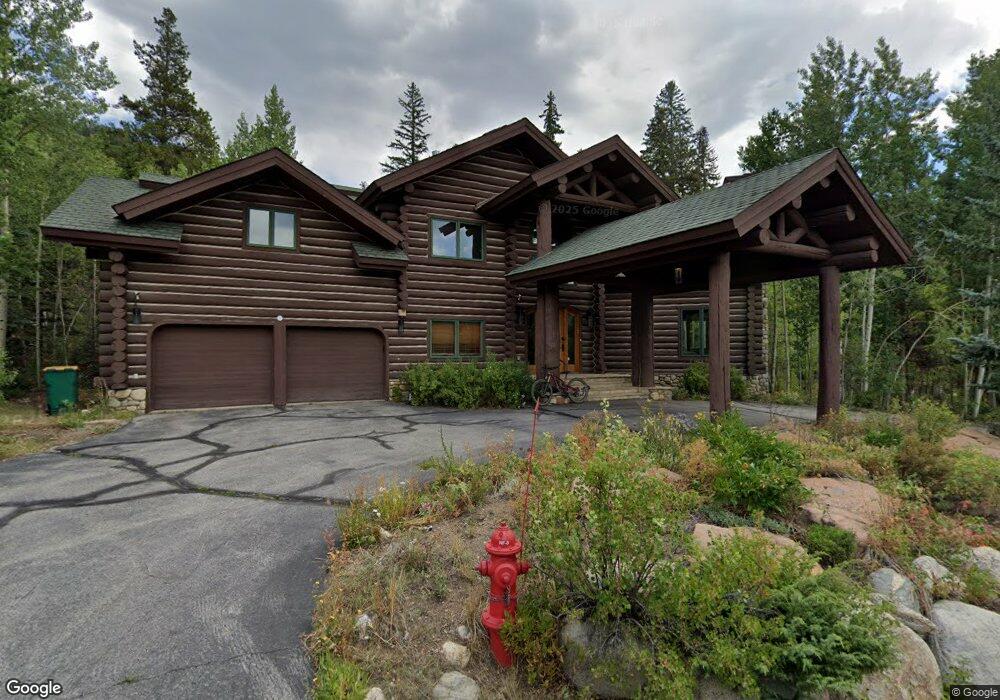
044 Arapahoe Trail Dillon, CO 80435
Keystone NeighborhoodEstimated Value: $3,730,448 - $4,592,000
4
Beds
4
Baths
5,469
Sq Ft
$748/Sq Ft
Est. Value
About This Home
This home is located at 044 Arapahoe Trail, Dillon, CO 80435 and is currently estimated at $4,088,362, approximately $747 per square foot. 044 Arapahoe Trail is a home located in Summit County with nearby schools including Summit Cove Elementary School, Summit Middle School, and Summit High School.
Ownership History
Date
Name
Owned For
Owner Type
Purchase Details
Closed on
Feb 10, 2022
Sold by
Ben Baer Iii
Bought by
Baer Investments Lp
Current Estimated Value
Home Financials for this Owner
Home Financials are based on the most recent Mortgage that was taken out on this home.
Original Mortgage
$215,000
Outstanding Balance
$199,644
Interest Rate
3.55%
Mortgage Type
New Conventional
Estimated Equity
$3,888,718
Purchase Details
Closed on
Dec 28, 2020
Sold by
Baer Ben and Baer Larisa
Bought by
Baer Investments Lp
Purchase Details
Closed on
May 26, 2017
Sold by
Clary Michael R and Clary Joyce Louise
Bought by
Baer Ben and Baer Larisa
Home Financials for this Owner
Home Financials are based on the most recent Mortgage that was taken out on this home.
Original Mortgage
$1,000,000
Interest Rate
3.02%
Mortgage Type
Adjustable Rate Mortgage/ARM
Create a Home Valuation Report for This Property
The Home Valuation Report is an in-depth analysis detailing your home's value as well as a comparison with similar homes in the area
Home Values in the Area
Average Home Value in this Area
Purchase History
| Date | Buyer | Sale Price | Title Company |
|---|---|---|---|
| Baer Investments Lp | -- | None Listed On Document | |
| Baer Ben | -- | None Listed On Document | |
| Baer Investments Lp | -- | None Available | |
| Baer Ben | $2,150,000 | Land Title Guarantee Company |
Source: Public Records
Mortgage History
| Date | Status | Borrower | Loan Amount |
|---|---|---|---|
| Open | Baer Ben | $215,000 | |
| Previous Owner | Baer Ben | $1,000,000 |
Source: Public Records
Tax History Compared to Growth
Tax History
| Year | Tax Paid | Tax Assessment Tax Assessment Total Assessment is a certain percentage of the fair market value that is determined by local assessors to be the total taxable value of land and additions on the property. | Land | Improvement |
|---|---|---|---|---|
| 2024 | $12,286 | $231,103 | -- | -- |
| 2023 | $12,286 | $227,418 | $0 | $0 |
| 2022 | $9,729 | $170,275 | $0 | $0 |
| 2021 | $9,814 | $175,175 | $0 | $0 |
| 2020 | $7,728 | $147,366 | $0 | $0 |
| 2019 | $7,622 | $147,366 | $0 | $0 |
| 2018 | $5,784 | $108,368 | $0 | $0 |
| 2017 | $4,939 | $101,168 | $0 | $0 |
| 2016 | $4,796 | $96,763 | $0 | $0 |
| 2015 | $4,646 | $96,763 | $0 | $0 |
| 2014 | $4,720 | $97,049 | $0 | $0 |
| 2013 | -- | $97,049 | $0 | $0 |
Source: Public Records
Map
Nearby Homes
- 140 Ida Belle Dr Unit 8161
- 140 Ida Belle Dr Unit 8192
- 140 Ida Belle Dr Unit 8310
- 140 Ida Belle Dr Unit 8283
- 140 Ida Belle Dr Unit 8153
- 140 Ida Belle Dr Unit 8214
- 140 Ida Belle Dr Unit 8294
- 140 Ida Belle Dr Unit 8178
- 53 Hunki Dori Ct Unit 8881
- 53 Hunki Dori Ct Unit 8802
- 53 Hunki Dori Ct Unit 8886
- 53 Hunki Dori Ct Unit 8905
- 53 Hunki Dori Ct Unit 8863
- 20 Hunki Dori Ct Unit 2262
- 20 Hunki Dori Ct Unit 2241
- 20 Hunki Dori Ct Unit 2225
- 20 Hunki Dori Ct Unit 2215
- 100 Dercum Square Unit 8361
- 58 Hawk Cir Unit 2342
- 75 Hunki Dori Ct Unit E107
- 44 Arapahoe Trail
- 66 Arapahoe Trail
- 31 Arapahoe Trail
- 16 Arapahoe Trail
- 57 Stoney Trail
- 29 Stoney Trail
- 110 N Fork Rd
- 225 N Fork Rd
- 263 N Fork Rd
- 28 N Fork Rd
- 227 N Fork Rd
- 26 N Fork Rd
- 491 Montezuma Rd
- 38 N Fork Rd
- 483 Montezuma Rd
- 48 Winter Ridge Rd
- 505 Montezuma Rd
- 535 Montezuma Rd
- 0 Ida Belle Dr Unit 7493474
- 0 Ida Belle Dr Unit 703214